Saint-Julien-lès-Montbéliard
| Saint-Julien-lès-Montbéliard | ||
|---|---|---|
|
|
||
| region | Bourgogne-Franche-Comté | |
| Department | Doubs | |
| Arrondissement | Montbeliard | |
| Canton | Bavans | |
| Community association | Pays de Montbéliard agglomeration | |
| Coordinates | 47 ° 31 ' N , 6 ° 43' E | |
| height | 344-447 m | |
| surface | 3.81 km 2 | |
| Residents | 165 (January 1, 2017) | |
| Population density | 43 inhabitants / km 2 | |
| Post Code | 25550 | |
| INSEE code | 25521 | |
| Website | www.saint-julien-les-montbeliard.fr | |
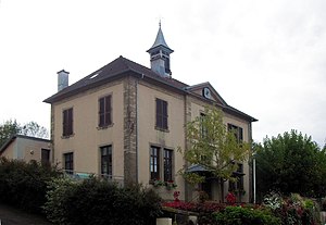
 Mairie of Saint-Julien-lès-Montbéliard |
||
Saint-Julien-lès-Montbéliard is a French municipality with 165 inhabitants (as of January 1 2017) in Doubs in the region Bourgogne Franche-Comté .
geography
Saint-Julien-lès-Montbéliard is located at 370 m , about seven kilometers west of the city of Montbéliard (as the crow flies). The village extends on the eastern edge of a plateau, which is embedded in the undulating landscape between the river valleys of Doubs in the south and Ognon in the north-west, south of the valley of the Rupt.
The area of the 3.81 km² municipal area covers a section of the gently undulating landscape north of the Doube valley. The northern border runs along the Rupt , which is dammed up here to form the Étangs des Princes (fish pond). From the brook, the community area extends southwards over the plateau of Saint-Julien-lès-Montbéliard to the adjacent, densely wooded height of the Grand Bois , where the highest point in the community is reached at 446 m. With a narrow strip of the community soil extends west to the plateau of Arcey, which is on average 360 m. It is mostly made up of arable and meadow land.
Neighboring municipalities of Saint-Julien-lès-Montbéliard are Échenans and Raynans in the north, Issans in the east, Dung , Présentevillers and Sainte-Marie in the south and Arcey in the west.
history
Saint-Julien is first mentioned in a document in 1150 under the name of Sanctus Julianus . Over time, the spelling changed from Sainct Gellin (1378), Sainct Gelin (1554), Sainct Gelien (1566) to Sainct Julien (1649). Since the Middle Ages, Saint-Julien belonged to the domain of the Counts of Mömpelgard (Montbéliard) . They introduced the Reformation in 1540 . During the Burgundian Wars (1474) and the Thirty Years War , the village was affected. With the annexation of the county of Württemberg-Mömpelgard (Montbéliard) , Saint-Julien finally came into French hands in 1793. To avoid confusion with other municipalities of the same name, Saint-Julien was officially renamed Saint-Julien-lès-Montbéliard in 1962. Today the village is part of the Pays de Montbéliard Agglomération municipal association .
Attractions
The Protestant Lutheran Church ( Temple luthérien ) of Saint-Julien stands outside the village on the edge of the forest of the Grand Bois. It was built in 1744 as one of the twenty churches that were rebuilt or renovated on behalf of Duke Karl Eugen during his long reign. It was extensively restored in 1848 and 1902. Other attractions in the village include the old rectory (built in 1675), another house from 1624, the lavoir (wash house) from the 18th century and various farmhouses in the traditional Franche-Comté style from the 18th and 19th centuries.
population
| Population development | |
|---|---|
| year | Residents |
| 1962 | 89 |
| 1968 | 102 |
| 1975 | 122 |
| 1982 | 153 |
| 1990 | 174 |
| 1999 | 173 |
| 2016 | 166 |
With 165 inhabitants (as of January 1, 2017), Saint-Julien-lès-Montbéliard is one of the small communities in the Doubs department. After the population in the first half of the 20th century had always been in the range between 97 and 116 people, there has been a significant increase in population since the beginning of the 1960s. Since then the number of inhabitants has doubled.
Economy and Infrastructure
Until well into the 20th century, Saint-Julien-lès-Montbéliard was primarily a village characterized by agriculture (arable farming, fruit growing and cattle breeding) and fish farming. In addition, there are now some local small businesses. In the meantime, the village has also turned into a residential community. Many workers are therefore commuters who do their work in the Montbéliard agglomeration.
The village is off the major thoroughfares on a departmental road that leads from Sainte-Marie to Raynans. The closest connection to the A36 motorway is around 13 kilometers away. Another road connection is with Échenans.
literature
- Le Patrimoine des Communes du Doubs. Volume 2, Flohic Editions, Paris 2001, ISBN 2-84234-087-6 , pp. 726-727.
Remarks
- ↑ See "Saint Julien les Montbéliard: le temple luthérien", on: Les temples ou églises luthériennes de France - [Recherche alphabétique: S], accessed on January 21, 2016.
- ↑ Georges-Frédéric Goguel, Précis historique de la Réformation et des églises protestantes dans l'ancien comté de Montbéliard et ses dépendances , Paris: Marc-Aurel frères, 1841, p. 148.

