Fournet Blancheroche
| Fournet Blancheroche | ||
|---|---|---|
|
|
||
| region | Bourgogne-Franche-Comté | |
| Department | Doubs | |
| Arrondissement | Montbeliard | |
| Canton | Maîche | |
| Community association | Pays de Maîche | |
| Coordinates | 47 ° 10 ′ N , 6 ° 50 ′ E | |
| height | 574-1,031 m | |
| surface | 13.08 km 2 | |
| Residents | 357 (January 1, 2017) | |
| Population density | 27 inhabitants / km 2 | |
| Post Code | 25140 | |
| INSEE code | 25255 | |
 Mairie (local government) |
||
Fournet-Blancheroche is a French municipality with 357 inhabitants (as of January 1 2017) in Doubs in the region Bourgogne Franche-Comté .
geography
Fournet-Blancheroche is located at 958 m , ten kilometers south of Maîche and about seven kilometers north of the Swiss city of La Chaux-de-Fonds (as the crow flies). The village extends in the Jura , on a slope inclined slightly to the southeast on a ridge on the southern edge of the Maîche plateau high above the Doubs valley , near the border with Switzerland .
The area of the 13.08 km² municipal area covers a section of the French Jura. The main part of the area is taken up by the wide ridges that accompany the Doubstal on its north side. At 1031 m, the highest point of Fournet-Blancheroche is reached near the Grand Mont . The heights are mainly made up of meadow and pasture land, but also show some larger forest areas. To the north, the municipal area extends to the high plateau of Maîche, which averages 880 m. The plateau has no above-ground watercourses because the rainwater seeps into the karstified subsoil.
Towards the south the terrain slopes steeply to the canyon-like valley of the Doubs, which is cut into the Jura plateau. To the east of Fournet-Blancheroche, the river forms a large loop. It is dammed up to a lake by the weir of Refrain. The predominantly wooded valley slopes are criss-crossed by various striking limestone walls. In the south and east the border always runs along the Doubs.
Fournet-Blancheroche consists of different districts, hamlets and individual farms, namely:
- Fournet ( 958 m ) on the northeastern foothills of the Grand Mont
- Blancheroche ( 921 m ) on the plateau above the bend of the Doubs
- Le Mont Pré ( 985 m ) on the northeastern foothills of the Grand Mont
- Le Refrain ( 816 m ) on the northern slope of the Doubs
Neighboring municipalities of Fournet-Blancheroche are Bonnétage in the west, Frambouhans , Les Écorces and Charquemont in the north and the Swiss municipalities of Les Bois in the east and La Chaux-de-Fonds in the south.
history
The towns of Fournet and Blancheroche were united with Charquemont after the French Revolution . Since 1874, however, Fournet-Blancheroche has again formed an independent municipality.
Attractions
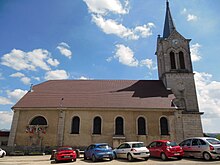
The village church Notre-Dame-des-Victoires in Fournet was built in 1720 and enlarged in 1807. The Belvédère de La Cendrée offers a view of the deeply cut Doubstal.
population
| Population development | |
|---|---|
| year | Residents |
| 1962 | 290 |
| 1968 | 232 |
| 1975 | 223 |
| 1982 | 215 |
| 1990 | 224 |
| 1999 | 256 |
| 2016 | 366 |
With 357 inhabitants (as of January 1, 2017) Fournet-Blancheroche is one of the small communities in the Doubs department. After the population had decreased markedly in the first half of the 20th century (669 people were still counted in 1891), only slight fluctuations have been recorded since the early 1970s.
Economy and Infrastructure
Until well into the 20th century, Fournet-Blancheroche was primarily a village characterized by agriculture (cattle breeding and dairy farming) and forestry. In addition, there are now some local small businesses. Many workers are also commuters who work in the surrounding larger towns or commute to Switzerland as cross-border commuters.
The village is located off the major thoroughfares on a departmental road that leads from Maîche via Biaufond to La Chaux-de-Fonds. Other road connections exist with Le Russey and Grand'Combe-des-Bois.

