
Mancenans
| Mancenans | ||
|---|---|---|

|
|
|
| region | Bourgogne-Franche-Comté | |
| Department | Doubs | |
| Arrondissement | Montbeliard | |
| Canton | Bavans | |
| Community association | Deux Vallées Vertes | |
| Coordinates | 47 ° 27 ' N , 6 ° 33' E | |
| height | 283-501 m | |
| surface | 11.94 km 2 | |
| Residents | 308 (January 1, 2017) | |
| Population density | 26 inhabitants / km 2 | |
| Post Code | 25250 | |
| INSEE code | 25365 | |

Mancenans is a French municipality with 308 inhabitants (as of January 1 2017) in Doubs in the region Bourgogne Franche-Comté .
geography
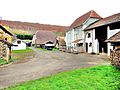
Mancenans is 300 m , three kilometers west of L'Isle-sur-le-Doubs and about 20 kilometers west-southwest of the city of Montbéliard (as the crow flies). The village extends in a valley north of the Doube valley between the hills of Châtel and Replain, at the foot of the limestone plateaus that adjoin the Doube valley to the north.
The area of the 11.94 km² municipal area includes a section of the Doubstal. The southern border runs along the Doubs, which flows here with large loops in an approximately one kilometer wide flat valley and at the same time forms the waterway of the Rhine-Rhône Canal . From the course of the river, the municipal area extends northward over the floodplain into the Mancenans basin, which is flanked by the wooded hills of Châtel ( 426 m ; in the west) and Replain ( 428 m ; in the east). To the north of these hills the terrain rises gently to the limestone plateau between the Doubs and Ognon . Here the highest elevation of Mancenans is reached with 501 m. The high plateau shows a loose structure of arable and meadow land as well as forest areas. The eastern border of the municipality runs in the dry valley of the Combe Ainé .
Neighboring municipalities of Mancenans are Accolans in the north, Geney , Étrappe and Appenans in the east, Rang and Pompierre-sur-Doubs in the south and Soye in the west.
history
Mancenans developed next to the Cistercian monastery Lieucroissant , founded in the 12th century and called Les Trois Rois since the 16th century. In the Middle Ages, the village belonged to the lordship of L'Isle-sur-le-Doubs. Together with Franche-Comté , it came to France with the Peace of Nijmegen in 1678. Today Mancenans is part of the Deux Vallées Vertes municipal association .
Attractions
The Church de la Protection de Notre-Dame was built around 1860 and consecrated in 1877. Compared to this hall church, the free-standing bell tower is relatively small. Only a few remains of the former monastery have survived.

Protection de Notre-Dame church
Remains of the former monastery
._2014-()3-14._copie.jpg)
.JPG)

population
| Population development | |
|---|---|
| year | Residents |
| 1962 | 281 |
| 1968 | 255 |
| 1975 | 322 |
| 1982 | 350 |
| 1990 | 322 |
| 1999 | 284 |
| 2006 | 346 |
| 2016 | 312 |
With 308 inhabitants (as of January 1, 2017) Mancenans is one of the small communities in the Doubs department. After the population had decreased significantly in the first half of the 20th century (443 people were still counted in 1886), population growth has been recorded again, especially in recent years.
Economy and Infrastructure
Until well into the 20th century, Mancenans was a village dominated by agriculture (arable farming, fruit growing and cattle breeding) and forestry. In addition, there are now some local small businesses. In the meantime, the village has also turned into a residential community. Many workers are therefore commuters who work in the larger towns in the area.
The village is off the major thoroughfares on a departmental road that leads from L'Isle-sur-le-Doubs to Rougemont . The closest connection to the A36 motorway is around ten kilometers away.