Bavans
| Bavans | ||
|---|---|---|

|
|
|
| region | Bourgogne-Franche-Comté | |
| Department | Doubs | |
| Arrondissement | Montbeliard | |
| Canton | Bavans (main town) | |
| Community association | Pays de Montbéliard agglomeration | |
| Coordinates | 47 ° 29 ′ N , 6 ° 44 ′ E | |
| height | 300-487 m | |
| surface | 8.83 km 2 | |
| Residents | 3,640 (January 1, 2017) | |
| Population density | 412 inhabitants / km 2 | |
| Post Code | 25550 | |
| INSEE code | 25048 | |
| Website | http://www.bavans.fr/ | |
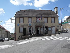
 Mairie Bavans |
||
Bavans is a French commune with 3,640 inhabitants (as of January 1 2017) in Doubs in the region Bourgogne Franche-Comté .
geography
Bavans is located at 330 m , about six kilometers southwest of the city of Montbéliard (as the crow flies). The village extends on a terrace north of the Doubstal opposite Dampierre-sur-le-Doubs, southwest of Mont Bart and on the northern edge of the extreme ridges of the Jura .
The area of the 8.83 km² municipal area includes a section of the Doubstal. The southern border runs along the Doubs, which flows here with several turns in a flat valley low about one kilometer wide and is accompanied by the waterway of the Rhine-Rhône Canal . To the east, the municipality extends to the mouth of the Allaine in the Doubs. From the course of the river, the community area extends northward over the valley floodplain and a 10 to 20 m high step onto the terrace of Bavans (320 to 340 m). To the north, the terrace rises slightly before a wooded slope leads over to the long ridge of Mont Bart. At 487 m, the highest point in Bavans is reached in the area of Fort du Mont Bart. This wooded ridge forms the northern boundary of the municipality. Only in a narrow strip does the area extend down to the Présentevillers basin to the north.
Neighboring municipalities of Bavans are Sainte-Marie and Présentevillers in the north, Bart in the east, Voujeaucourt , Berche , Dampierre-sur-le-Doubs and Étouvans in the south and Lougres in the west.
history
The municipality of Bavans was already settled in prehistoric times, which has been proven by various finds, including a burial ground from the Bronze Age . The place was probably founded by the Burgundians in the 6th or 7th century. Bavans has belonged to the Mömpelgard (Montbéliard) county since the Middle Ages . Largely depopulated by the plague epidemics and the Guisen attack at the end of the 16th century, Protestant emigrants from Switzerland settled in Bavans. With the occupation of the county of Württemberg-Mömpelgard (Montbéliard) , the village finally came into French hands in 1793. There was an economic boom in the middle of the 19th century with the construction of the national road N463 from Montbéliard to Besançon. After the Franco-Prussian War , the fort of the same name was built on Mont Bart from 1873 to 1877 as part of the Belfort-Montbéliard fortress system. Bavans has been part of the Pays de Montbéliard Agglomération community association since 2017 .
population
With 3,640 inhabitants (as of January 1, 2017) Bavans is one of the medium-sized municipalities in the Doubs department. After the population in the first half of the 20th century had always been in the range between 970 and 1090 people, a striking population growth was recorded from 1950 to 1980. During this time, the population has quadrupled. In the mid-1980s, the highest level was reached with around 4200 inhabitants. Since then a decrease of a little more than 10% has been registered. Today the settlement area of Bavans has grown together with that of Bart and Voujeaucourt.
| Population development | ||||||||
|---|---|---|---|---|---|---|---|---|
| year | 1962 | 1968 | 1975 | 1982 | 1990 | 1999 | 2008 | 2016 |
| Residents | 1.914 | 2,594 | 3,754 | 4.148 | 4.144 | 3,917 | 3,573 | 3,661 |
Attractions
The Lutheran Church of Bavans (Temple luthérien) was rebuilt in the 18th century in the classical style and restored in 1843/44 and 1920. Its predecessor was built around 1050. The Fort du Mont Bart is located on Mont Bart, which has been preserved in its original state (1873-77) and offers a beautiful view of the Montbéliard region.
Economy and Infrastructure
Until the beginning of the 20th century, Bavans was mainly a village characterized by agriculture (arable farming, fruit growing and cattle breeding) and forestry. Since the 1970s, several industrial and commercial zones have been created in the Doubstal along the main road. Companies from the logistics, research and development, transport and construction industries have settled here. There are also numerous retail stores. In the meantime, the village has also turned into a residential community. Many workers are therefore commuters who do their work in the Montbéliard agglomeration.
The village is well developed in terms of traffic. It is located on the RN 463 , which leads from Montbéliard to L'Isle-sur-le-Doubs and on to Besançon . The closest connection to the A36 motorway is around six kilometers away. Another road connection is with Présentevillers.
literature
- Le Patrimoine des Communes du Doubs. Volume 2, Flohic Editions, Paris 2001, ISBN 2-84234-087-6 , pp. 694-695.
Web links
Individual evidence
- ↑ See "Bavans: le temple luthérien" , on: Les temples ou églises luthériennes de France , accessed on January 23, 2016.


