Bournois
| Bournois | ||
|---|---|---|
|
|
||
| region | Bourgogne-Franche-Comté | |
| Department | Doubs | |
| Arrondissement | Montbeliard | |
| Canton | Bavans | |
| Community association | Deux Vallées Vertes | |
| Coordinates | 47 ° 30 ′ N , 6 ° 30 ′ E | |
| height | 330-521 m | |
| surface | 10.48 km 2 | |
| Residents | 192 (January 1, 2017) | |
| Population density | 18 inhabitants / km 2 | |
| Post Code | 25250 | |
| INSEE code | 25083 | |
Bournois is a French municipality with 192 inhabitants (as of January 1 2017) in Doubs in the region Bourgogne Franche-Comté .
geography
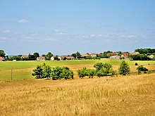
Bournois is located at an altitude of 405 m above sea level, nine kilometers northwest of L'Isle-sur-le-Doubs and about 23 kilometers west of the city of Montbéliard (as the crow flies). The village extends on a plateau in the hilly landscape between the lowlands of Doubs in the south and Ognon in the north, at the source of the Ruisseau de Fallon.
The area of the 10.48 km² municipal area includes a section of the hilly landscape north of the Doube valley. The main part of the area is occupied by a gently undulating limestone plateau, which extends at an altitude of 400 to 500 m. It shows a loose structure and arable and meadow land as well as forest areas. To the south is the Bois du Chanois forest . There are no surface rivers here because the rainwater seeps into the karstified subsoil of the limestone plateaus. Karst phenomena occur in various places, including the Grotte de la Baume (stalactite cave) and the Gouffre de la Malatière . At 521 m, the highest point of Bournois is reached on the plateau. To the north, the plateau ends in several projections (including the Grammont , 512 m), which descend to the lowlands of the Ognon with a 100 m high steep step. The municipal boundary mostly runs above the steep edge, only at Fallon does the area extend down into a wide hollow.
Neighboring communities of Bournois are Fallon and Grammont in the north, Accolans in the east, Soye , Gondenans-Montby and Uzelle in the south and Abbenans in the west.
history
Traces from the Gallo-Roman period indicate that the municipal area of Bournois was settled early on. In the Middle Ages, Bournois was part of the Granges rule, which came under the suzerainty of the Counts of Montbéliard in the 14th century. Together with Franche-Comté, the village came to France with the Peace of Nijmegen in 1678. Today Bournois is a member of the Deux Vallées Vertes municipal association .
Attractions
The Saint-Nicolas church, which originally dates back to a Romanesque building, was rebuilt in the mid-19th century. Various houses in the traditional Franche-Comté style from the 17th to 19th centuries have been preserved in the town center.
population
| Population development | |
|---|---|
| year | Residents |
| 1962 | 162 |
| 1968 | 177 |
| 1975 | 177 |
| 1982 | 208 |
| 1990 | 212 |
| 1999 | 209 |
| 2006 | 177 |
| 2016 | 191 |
With 192 inhabitants (as of January 1, 2017) Bournois is one of the small communities in the Doubs department. After the population had decreased significantly in the first half of the 20th century (455 people were still counted in 1886), the population grew at the end of the 1970s, but has fallen again in recent years.
Economy and Infrastructure
Until well into the 20th century, Bournois was primarily a village characterized by agriculture (arable farming, fruit growing and cattle breeding) and forestry. In addition, there are now some local small businesses. In the meantime the village has turned into a residential community. Many workers are therefore commuters who work in the larger towns in the area.
The village is off the main thoroughfares on a departmental road that leads from Fallon to Accolans. Other road links exist with Soye and Gondenans-Montby.

