Solemont
| Solemont | ||
|---|---|---|
|
|
||
| region | Bourgogne-Franche-Comté | |
| Department | Doubs | |
| Arrondissement | Montbeliard | |
| Canton | Valentigney | |
| Community association | Pays de Montbéliard agglomeration | |
| Coordinates | 47 ° 21 ' N , 6 ° 42' E | |
| height | 394-831 m | |
| surface | 8.09 km 2 | |
| Residents | 150 (January 1, 2017) | |
| Population density | 19 inhabitants / km 2 | |
| Post Code | 25190 | |
| INSEE code | 25548 | |
 Mairie Solemont |
||
Solemont is a French commune of 150 inhabitants (as of January 1, 2017) in the Doubs department in the region of Bourgogne Franche-Comté .
geography
Solemont is located at 520 m , seven kilometers southwest of Pont-de-Roide-Vermondans and about 20 kilometers south-southwest of the city of Montbéliard (air line). The village extends in the Jura , at the southern foot of the Lomont range , on a plateau above the Barbèche valley.
The area of the 8.09 km² large municipality covers a section of the French Jura. The main part of the area is occupied by the Solemont plateau, which is on average 520 m. This area is mostly made up of arable and meadow land. It is bordered in the west by the village stream Bief de Veau , in the south and east by the valley of the Barbèche (left tributary of the Doubs ). The steep valley slopes are criss-crossed by ledges in various places. To the north, the community area extends over a relatively steep, wooded slope, which is subdivided by the erosion basin of the village stream, up to the ridge of the Lomont chain in the area of Mont Solemont. From a geological and tectonic point of view, this ridge forms an anticline of the Jura folds and is oriented in a west-east direction. At 831 m, the highest point in Solemont is reached on Mont Solemont.
The neighboring municipalities of Solemont are Dambelin , Rémondans-Vaivre and Neuchâtel-Urtière in the north, Feule in the east, Les Terres-de-Chaux and Péseux in the south and Valonne in the west.
history
In the Middle Ages, Solemont was part of the domain of Châtillons-sous-Maîche. Together with Franche-Comté , the village came to France with the Peace of Nijmegen in 1678.
Attractions
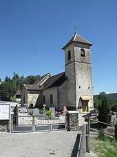
The village church of Saint-Michel was built in 1717; the choir and the sacristy date from 1822.
population
| Population development | |
|---|---|
| year | Residents |
| 1962 | 116 |
| 1968 | 99 |
| 1975 | 68 |
| 1982 | 178 |
| 1990 | 207 |
| 1999 | 185 |
| 2016 | 158 |
With 150 inhabitants (as of January 1, 2017) Solemont is one of the small communities in the Doubs department. After the population in the first half of the 20th century had always been in the range between 110 and 140 people, after a temporary decrease since the mid-1970s, a significant population growth was recorded again.
Economy and Infrastructure
Until well into the 20th century, Solemont was mainly a village characterized by agriculture (arable farming, fruit growing and cattle breeding). The hydropower of the Bief de Veau was used early on to operate a mill. In addition, there are now some local small businesses. Many workers are also commuters who work in the larger towns in the area.
The village is located away from the larger thoroughfares. The main access is from the departmental road that leads from Noirefontaine through the Barbèche valley to Sancey-le-Grand . Another road connection exists with Feule.
literature
- Le Patrimoine des Communes du Doubs. Volume 2, Flohic Editions, Paris 2001, ISBN 2-84234-087-6 , pp. 942-943.

