Mathay
| Mathay | ||
|---|---|---|

|
|
|
| region | Bourgogne-Franche-Comté | |
| Department | Doubs | |
| Arrondissement | Montbeliard | |
| Canton | Valentigney | |
| Community association | Pays de Montbéliard agglomeration | |
| Coordinates | 47 ° 26 ' N , 6 ° 47' E | |
| height | 330-551 m | |
| surface | 14.85 km 2 | |
| Residents | 2,158 (January 1, 2017) | |
| Population density | 145 inhabitants / km 2 | |
| Post Code | 25700 | |
| INSEE code | 25370 | |
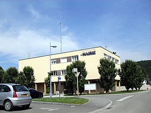
 Mairie Mathay |
||
Mathay is a French commune with 2,158 inhabitants (as of January 1 2017) in Doubs in the region Bourgogne Franche-Comté .
geography
Mathay is located at 341 m , about eight kilometers south of the city of Montbéliard (as the crow flies). The street village extends in the valley of the Doubs on the left bank of the river, in the northern French Jura between the heights of Bois de Mathay in the west and the high plateau of Blamont in the east.
The area of the 14.85 km² municipality covers a section of the French Jura. The central part of the area is taken up by the valley level of the Doubs, which flows here with several windings through a flat valley about 1.5 kilometers wide to the north and below the village draws a sharp curve to the east. The eastern border always runs along the Doubs. Former gravel and sand pits were filled with water in the valley floor, creating a large quarry pond south of the village. From the course of the river, the community area extends westward over the valley floor and a relatively steep slope, which is divided by various short erosion valleys, up to the adjacent heights. These are mostly forested: Bois de Saint-Symphorien ( 408 m ) and Bois de Bambe ( 412 m ) in the north, Bois de Mathay ( 427 m ) in the north-west and the heights of Lucelans in the west, which rise slowly to the Grands Bois . At 551 m, the highest elevation of Mathay is reached near Lucelans. In the far west, the communal soil extends into the Combes valley .
The hamlet of Lucelans ( 530 m ) on the Tafeljura plateau west of the Doube valley belongs to Mathay . Neighboring communities of Mathay are Voujeaucourt and Valentigney in the north, Mandeure in the east, Bourguignon in the south and Écot , Dampierre-sur-le-Doubs and Berche in the west.
history
Some remains indicate that the Mathay parish was already inhabited during the Bronze Age . As it is in direct proximity to the Roman city of Epomanduodurum ( Mandeure ), numerous traces (wall foundations, hypocausts, fountains, ceramic fragments, coins) bear witness to the Gallo-Roman settlement. At that time the traffic route from Vesontio ( Besançon ) to Augusta Raurica led through Mathay .
In the 12th century, the Mathay area belonged to the monastery of Baume-les-Dames . Later, the Lords of Neuchâtel held suzerainty over the village. Together with Franche-Comté , it came to France with the Peace of Nijmegen in 1678. The area changed in 1867 when the previously independent Lucelans was incorporated into Mathay. Today Mathay belongs to the municipality association Pays de Montbéliard Agglomération .
Attractions
The Saint-Pierre-et-Saint-Paul church was built in the 18th century. She owns a statue of Notre-Dame Blanche, which was sunk in the Doubs at the time of the Reformation and was probably part of the furnishings of the Saint-Maimbœuf church in Montbéliard. Outside the village at the foot of the height of the same name is the Saint-Symphorien chapel, which originally dates back to the 12th century, but has since been extensively restored several times. Only a few remains of a medieval castle have survived.
- Saint-Pierre-et-Saint-Paul church
population
| Population development | |
|---|---|
| year | Residents |
| 1962 | 1,172 |
| 1968 | 1,360 |
| 1975 | 1,482 |
| 1982 | 1,634 |
| 1990 | 1,960 |
| 1999 | 1,988 |
| 2007 | 2.138 |
| 2016 | 2,166 |
With 2158 inhabitants (as of January 1, 2017) Mathay is one of the medium-sized communities in the Doubs department. After the population in the first half of the 20th century had always been in the range between 600 and 700 people, there has been a significant increase in population since the early 1960s. Since then the number of inhabitants has doubled. The settlement area of Mathay expanded along the main roads and is now almost seamlessly merged with those of Mandeure and Bourguignon.
Economy and Infrastructure
For a long time Mathay was predominantly a village characterized by agriculture (arable farming, fruit growing and cattle breeding) and forestry. In the course of the 20th century, more and more trade and industry settled here in the wake of the Montbéliard agglomeration. The textile industry, precision mechanics and wood processing are among the important branches of industry. In the meantime, the village has also turned into a residential community. Many workers are therefore commuters who do their work in the Montbéliard agglomeration.
The village is well developed in terms of traffic. It is on the main road that leads from Montbéliard via Pont-de-Roide-Vermondans to Morteau . The nearest connection to the A36 motorway , which crosses the municipality, is around four kilometers away. Another important road connection is with Audincourt . The railway line from Montbéliard to Pont-de-Roide, which was inaugurated in 1886 and has a station near Mathay, is now only used for freight traffic. A bus line that runs from Montbéliard to Maîche connects Mathay to the public transport network.
literature
- Le Patrimoine des Communes du Doubs. Volume 2, Flohic Editions, Paris 2001, ISBN 2-84234-087-6 , pp. 929-931.


