Valoreille
| Valoreille | ||
|---|---|---|
|
|
||
| region | Bourgogne-Franche-Comté | |
| Department | Doubs | |
| Arrondissement | Montbeliard | |
| Canton | Maîche | |
| Community association | Pays de Maîche | |
| Coordinates | 47 ° 18 ' N , 6 ° 45' E | |
| height | 387-860 m | |
| surface | 7.58 km 2 | |
| Residents | 127 (January 1, 2017) | |
| Population density | 17 inhabitants / km 2 | |
| Post Code | 25190 | |
| INSEE code | 25584 | |
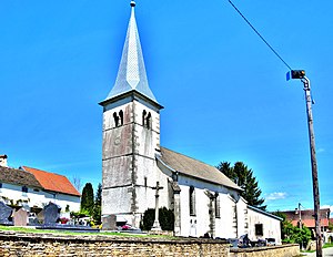
 Saint-François-Xavier church |
||
Valoreille is a French municipality with 127 inhabitants (as of January 1 2017) in Doubs in the region Bourgogne Franche-Comté .
geography
Valoreille is located at 720 m , six kilometers southwest of Saint-Hippolyte and about 24 kilometers south of the city of Montbéliard (as the crow flies). The village extends in the Jura , in a panoramic position on a slope of the Montaigu ridge that slopes slightly to the south, high above the Dessoubre valley , opposite Maîche .
The area of the 7.58 km² municipality covers a section of the French Jura. The northern part of the area is occupied by the wide ridge of the Montaigu , which separates the Dessoubre valley in the south from the plateau of Les Terres-de-Chaux in the north. At 865 m, the highest point of Valoreille is reached on this ridge. A front terrace runs parallel to the ridge on its southern slope, which slopes steeply towards the Dessoubre valley. To the south, the community area extends over the catchment area of a short left side valley down to the deeply incised course of the Dessoubre, which forms the southern border with its winding course.
Neighboring municipalities of Valoreille are Les Terres-de-Chaux in the north, Fleurey in the east, Orgeans-Blanchefontaine and Vauclusotte in the south and Belleherbe in the west.
history
In the Middle Ages, Valoreille belonged to the domain of Châtillon-sous-Maîche, which was under the sovereignty of the Counts of Burgundy . Together with Franche-Comté , the village came to France with the Peace of Nijmegen in 1678.
Attractions
The village church of Valoreille was built in the 17th century. The Maison des Seigneurs mansion next to the church dates from the 16th century. In the center there are numerous farmhouses in the traditional Franche-Comté style from the 16th to 19th centuries.
population
| Population development | |
|---|---|
| year | Residents |
| 1962 | 127 |
| 1968 | 107 |
| 1975 | 99 |
| 1982 | 110 |
| 1990 | 104 |
| 1999 | 90 |
| 2016 | 129 |
With 127 inhabitants (as of January 1, 2017) Valoreille is one of the smallest communities in the Doubs department. After the population had decreased significantly in the first half of the 20th century (232 people were still counted in 1881), only minor fluctuations have been recorded since the beginning of the 1970s.
Economy and Infrastructure
Until well into the 20th century, Valoreille was a village dominated by agriculture (cattle breeding and dairy farming, some arable and fruit growing). Even today, the residents live mainly from their work in the first sector. Outside the primary sector there are few jobs in the village. Some workers are also commuters who work in the surrounding larger towns.
The village is located away from the major thoroughfares on the D255 department road, which leads from Saint-Hippolyte to Belleherbe. There are other road connections with Vauclusotte and Les Terres-de-Chaux.
literature
- Le Patrimoine des Communes du Doubs. Volume 2, Flohic Editions, Paris 2001, ISBN 2-84234-087-6 , p. 1270.
