
Dampjoux
| Dampjoux | ||
|---|---|---|

|
|
|
| region | Bourgogne-Franche-Comté | |
| Department | Doubs | |
| Arrondissement | Montbeliard | |
| Canton | Maîche | |
| Community association | Pays de Maîche | |
| Coordinates | 47 ° 21 ' N , 6 ° 45' E | |
| height | 356-680 m | |
| surface | 2.31 km 2 | |
| Residents | 172 (January 1, 2017) | |
| Population density | 74 inhabitants / km 2 | |
| Post Code | 25190 | |
| INSEE code | 25192 | |
 Mairie Dampjoux |
||

Dampjoux is a French municipality with 172 inhabitants (as of January 1 2017) in Doubs in the region Bourgogne Franche-Comté .
geography
Dampjoux is located at 360 m , five kilometers south of Pont-de-Roide-Vermondans and about 19 kilometers south of the city of Montbéliard (beeline). The village extends in the Jura , in a valley widening of the Doubs on the left bank of the river, before its gorgeously breakthrough through the Lomont range , at the northeast foot of the heights of Les Terres-de-Chaux.
The area of the 2.31 km² municipal area covers a section of the French Jura. The area is bounded in the east by the Doubs and in the north by its left tributary Barbèche , which flows parallel to the Lomont chain. The Doubs has formed a deep valley here with a flat valley floor up to a kilometer wide. The hill Montoille ( 405 m ), which today is a characteristic circular mountain , testifies to a former bend in the river . From the course of the river, the municipality stretches westward over the valley and the adjacent steep, predominantly wooded slope up to the edge of the heights of Les Terres-de-Chaux. Here, at 680 m, the highest point in Dampjoux is reached.
Neighboring municipalities of Dampjoux are Feule and Villars-sous-Dampjoux in the north, Noirefontaine in the east, Bief in the south and Les Terres-de-Chaux in the west.
history
Dampjoux was first mentioned in writing in 1136 in a deed of ownership from the Lucelle monastery . From the 13th to the 15th century, Dampjoux belonged to the Mathay rule under the sovereignty of the Neuchâtel family . Since around 1500, one part of the village belonged to the lordship of Châtillon (under the suzerainty of the Counts of Burgundy), the other part to the lordship of Clémont, which was under the suzerainty of the principality of Württemberg-Mömpelgard (Montbéliard) . In 1748 Dampjoux finally came under French administration.
Attractions
The village church of St. George in Dampjoux was rebuilt in 1728.
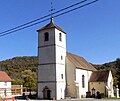
St. George Church

Interior of the church


population
| Population development | |
|---|---|
| year | Residents |
| 1962 | 115 |
| 1968 | 116 |
| 1975 | 125 |
| 1982 | 128 |
| 1990 | 113 |
| 1999 | 153 |
| 2016 | 176 |
With 172 inhabitants (as of January 1, 2017) Dampjoux is one of the smallest communities in the Doubs department. After the population in the first half of the 20th century was always in the range between 80 and 110 people, a slight population growth has been recorded since the beginning of the 1970s.
Economy and Infrastructure
Until well into the 20th century, Dampjoux was a village dominated by agriculture (cattle and dairy farming, arable and fruit growing). In addition, there are now some local small businesses. There is a hydroelectric power station on the Doubs. Many workers are also commuters who work in the larger towns in the area.
The community has good transport connections. It is located near the D437 departmental road that leads from Montbéliard through the Doubstal to Maîche . Another road connection is with Bief.
literature
- Le Patrimoine des Communes du Doubs. Volume 2, Flohic Editions, Paris 2001, ISBN 2-84234-087-6 , pp. 1241-1242.