Longevelle-sur-Doubs
| Longevelle-sur-Doubs | ||
|---|---|---|

|
|
|
| region | Bourgogne-Franche-Comté | |
| Department | Doubs | |
| Arrondissement | Montbeliard | |
| Canton | Bavans | |
| Community association | Pays de Montbéliard agglomeration | |
| Coordinates | 47 ° 27 ' N , 6 ° 39' E | |
| height | 295-432 m | |
| surface | 8.31 km 2 | |
| Residents | 682 (January 1, 2017) | |
| Population density | 82 inhabitants / km 2 | |
| Post Code | 25260 | |
| INSEE code | 25345 | |
Longevelle-sur-Doubs is a French municipality with 682 inhabitants (as of January 1 2017) in Doubs in the region Bourgogne Franche-Comté .
geography
Longevelle-sur-Doubs is located at 302 m , five kilometers east of L'Isle-sur-le-Doubs and about 13 kilometers west-southwest of the city of Montbéliard (beeline). The street village extends on the right (northern) bank of the Doubs , on the northern edge of the extreme ridges of the Jura .
The area of the 8.31 km² municipal area covers a section of the Doubstal. The southern border runs along the Doubs, which flows westwards in a flat valley about one kilometer wide and is accompanied by the waterway of the Rhine-Rhône Canal . From the course of the river, the community area extends northward over the valley floodplain and a 40 m high steep slope to the adjacent, predominantly wooded heights of a limestone plateau. From west to east these are the Bois de Cugnot ( 406 m ), the height of Longevelle ( 405 m ) and the Bois de Cujot , on which the highest point of Longevelle-sur-Doubs is reached at 432 m. The plateau is subdivided by various valleys (mostly without surface running water, because the rainwater seeps into the karstified subsoil).
Longevelle-sur-Doubs includes the hamlet of Les Beussières ( 310 m ), slightly elevated on the northern edge of the Doubs valley at the entrance to the Beutal basin. Neighboring communities of Longevelle-sur-Doubs are Beutal in the north, Lougres in the east, Colombier-Fontaine , Saint-Maurice-Colombier and Blussangeaux in the south and La Prétière in the west.
history
The municipality of Longevelle was settled very early, which was proven by excavation finds (tools) from the Paleolithic and the Bronze Age in the Abri La Roche-aux-Gours. During the Roman times there was an estate here.
Longevelle is mentioned for the first time in 1134 under the name Longavilla; from 1513 the name Longeveule has been handed down. The place name means something like long village in French . In the Middle Ages, Longevelle belonged to the Châtelot rule, which in 1561 came under the suzerainty of the Counts of Württemberg-Mömpelgard (Montbéliard) through purchase . They enforced the Reformation in Longevelle in 1565 and the church with the patronage of Assomption (Assumption of Mary) became Lutheran.
The French occupying power withdrew the Lutheran church for the Catholic rite in 1735. With the Versailles Treaty of 1748, the village came to France. With the recognition of the Lutherans as citizens, these Longevelles church regained in 1790. To avoid confusion with other communities of the same name, Longevelle was officially renamed Longevelle-sur-Doubs in 1923. Today Longevelle-sur-Doubs is part of the Pays de Montbéliard Agglomération .
Attractions
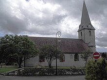
The Lutheran church of Longevelle-sur-Doubs (Temple luthérien) is essentially a pre-Reformation building. The choir, which was added in 1742, was removed again in 1822. The church tower was built in 1780, but did not get its current top until 1866. At the same time the Schiuff's small windows were replaced by large ones.
population
| Population development | |
|---|---|
| year | Residents |
| 1962 | 412 |
| 1968 | 448 |
| 1975 | 493 |
| 1982 | 493 |
| 1990 | 657 |
| 1999 | 604 |
| 2016 | 690 |
With 682 inhabitants (as of January 1, 2017) Longevelle-sur-Doubs is one of the small communities in the Doubs department. After the population in the first half of the 20th century had always been in the range between 290 and 360 people, population growth has been recorded since the early 1960s.
Economy and Infrastructure
Until well into the 20th century, Longevelle-sur-Doubs was a village dominated by agriculture (arable farming, fruit growing and cattle breeding) and forestry. In addition, there are now various local small businesses. In the meantime, the village has also turned into a residential community. Many workers are therefore commuters who work in the larger towns in the area and in the Montbéliard agglomeration.
The village is well developed in terms of traffic. It is on the main road N463, which leads from Montbéliard to L'Isle-sur-le-Doubs. The closest connection to the A36 motorway is around 14 kilometers away. Further road connections exist with Blussangeaux, Beutal and Saint-Maurice-Colombier.
Web links
Individual evidence
- ↑ a b c d e f g Cf. "Longevelle: le temple luthérien" , on: Les temples ou églises luthériennes de France , accessed on January 24, 2016.

