Huongolf
| Huongolf | ||
|---|---|---|
|
The Huongolf viewed from space (false color representation) |
||
| Waters | Solomon Lake | |
| Land mass | New Guinea | |
| Geographical location | 7 ° 19 ′ S , 147 ° 37 ′ E | |
|
|
||
| width | approx. 150 km | |
| depth | approx. 100 km | |
| Tributaries | Markham | |
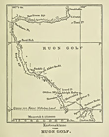
The Huongolf ( English Huon Gulf ) is a large sea inlet on the east coast of New Guinea in Papua New Guinea , in the former Kaiser Wilhelms-Land of German New Guinea . It is bounded in the north by the Huon Peninsula . Its northern entrance marks Cape Cretin , the southern Cape Longerue . The coast, which runs fairly evenly and rises rapidly from the beach, is limited to the North by the Rawlinson chain , to the west by the Kuper chain and others, which rise to about 600 m. It is named after the French explorer Jean-Michel Huon de Kermadec . The Huongolf is part of the Solomon Sea . Lae , the capital of the Morobe Province is located on the northern coast of the Gulf. In the depths of the gulf, therefore in its northwest corner, the Markham River flows into Markham Bay . The coastal islands are all small and insignificant.
The westernmost part of the Huongolf was called Preußenreede during German colonial times .

Individual evidence
- ↑ Preußenreede , in: Heinrich Schnee (Ed.): German Colonial Lexicon . Volume III, p. 101, Leipzig 1920.

