Markham (river)
| Markham | ||
|
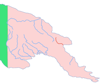
Location of the Markham in Papua New Guinea |
||
| Data | ||
| location | Papua New Guinea | |
| River system | Markham (river) | |
| Drain over | Markham → Pacific Ocean | |
| source | in the Finisterre Mountains 6 ° 6 ′ 30 ″ S , 146 ° 11 ′ 30 ″ E |
|
| Source height | 475 m | |
| muzzle |
Huongolf coordinates: 6 ° 44 ′ 20 " S , 146 ° 58 ′ 5" E 6 ° 44 ′ 20 " S , 146 ° 58 ′ 5" E |
|
| Mouth height | 0 m | |
| Height difference | 475 m | |
| Bottom slope | about 2.6 ‰ | |
| length | about 180 km | |
| Right tributaries | Watuf / Watuf | |
| Big cities | Lae | |
| Navigable | on 70 km | |
|
NASA World Wind full length satellite image of Markham, Lae to the left, looking west |
||
The Markham is a river in eastern Papua New Guinea , which has its source in the Finisterre Mountains , flows through the Markham Valley and after a little more than 180 km flows into the Huongolf at Lae .
The river was named after Clements Markham by Captain John Moresby in 1873 in honor of the then Secretary of the Royal Geographical Society . R. Neubaus first entered the river in its lower reaches in 1909 over a length of 70 km. The right-hand tributary Watuf was discovered in 1912 and 1913. Today this tributary is called the Watut .
swell
- ^ Gavin Souter: New Guinea: The Last Unknown . Angus & Robertson, 1963, ISBN 0207946272 , p. 77. (Eng.)
- ↑ The Markham River in the German Colonial Lexicon (1920), Volume 2, p. 508, on uni-frankfurt.de, accessed November 11, 2007
- ↑ tributary of Markham in the German Colonial Lexicon (1920), on uni-frankfurt.de accessed 11 November, 2007.

