
Canal de la Haute-Saône
| Canal de la Haute-Saône | |
|---|---|
 The Frahier harbor basin |
|
| Water code | FR : undefined |
| location | France, Franche-Comte region |
| length | 23 km |
| Built | 1882-1926 |
| class | <I. |
| Beginning | Branch from the Rhine-Rhône Canal at Fesches-le-Châtel |
| The End | at Ronchamp |
| Descent structures | 14th |
| Kilometrage | Towards botans |
| currently navigable over a length of 12.5 kilometers to the port of Botans | |
 |
|
The Canal de la Haute-Saône (German: Haute-Saône Canal ) is a French shipping canal that begins in the north of the Doubs department , crosses the southwest of the Territoire de Belfort and whose unfinished section was planned as a connection to the Haute-Saône department . The aim was to connect the Canal du Rhône au Rhin (German: Rhine-Rhône Canal ) with the upper Saône .
Alternative names:
- Canal de Montbéliard à la Haute-Saône
- Canal de Belfort
The length of the at least partially realized section is 23 kilometers and includes:
- a reservoir for dewatering
- a trough bridge
- a tunnel of 640 meters in length
- a tunnel 1330 meters long
- 9 canal bridges
- 14 locks
history
After the loss of Alsace in the Franco-Prussian War in 1871 , the government of the Third Republic decided to build canals in eastern France to allow goods to flow between the areas of Nancy , Burgundy and Franche-Comté . First the Canal de l'Est (today: Canal des Vosges ) was built, which was completed around 1887. At the same time, the construction of the Canal de la Haute-Saône began, which was to include the part that had remained French between the Canal du Rhône au Rhin and the Canal de l'Est. The aim was also to build an efficient connection to the Ronchamp coal mines .
In 1881 the project was largely defined and approved by the government. Construction began in 1882, but the difficulties encountered in digging through the tunnels and negotiating the deep trenches soon showed that the budget originally planned was underestimated. As additional loans were only approved very slowly, the construction project dragged on and could not be completed before the First World War . Since Alsace fell back to France after the end of the war, the canal project no longer made sense and it was therefore discontinued. The already completed section between Botans and the confluence with the Rhine-Rhône Canal (12.5 kilometers) was put into operation in 1926.
This port served as a coal port for Belfort until the 1970s . Since May 2018 this part of the canal from Dambenois has also been closed to shipping. The reasons for this are the increasing leaks and high maintenance costs. However, the banks of the canal have become a popular recreational area for the residents of Belfort and Montbéliard . The Champagney Basin was built as a water reservoir (13 million cubic meters) to regulate the water level in the canal. It currently forms a lake that is very popular with fishermen and local bathers.
course
One can distinguish three parts:
- the section between Fesches-le-Châtel and Dambenois that is actually in operation
- the section between Botans and Ronchamp, which has only been partially built
- the section between Ronchamp and the Saône, which never got beyond the planning stage
From Fesches-le-Châtel to Botans
the canal runs through the following places:
- Fesches-le-Châtel (confluence with the Rhine-Rhône Canal )
- Allenjoie (canal bridge over the Allaine )
- Brognard
- Dambenois
- Trévenans
- Bermont (canal bridge over the Savoureuse )
- Botans (port)
From Botans to Ronchamp
the built canal elements run through the following places:
- Botans
- Andelnans
- Bavilliers
- Eats
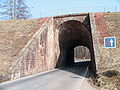
- Châlonvillars ( La Forêt tunnel )
- Frahier-et-Chatebier
- Champagney (Basin of Champagney, Tunnel of Chérimont )
- Ronchamp (planned coal port)
From Ronchamp to the Saône
the canal should run through the following places:
- Ronchamp
- La Cote
- Roye
- Lure
- Magny-Vernois
- Amblans
- Mollans
- Pomoy
- Creveney
- Colombier
- Coulevon
- Vesoul
- Montoille
- Montigny-lès-Vesoul
- Pontcey
- Chemilly (confluence with the Saône)
Coordinates
- Starting point of the canal: 47 ° 31 ′ 27 ″ N , 6 ° 53 ′ 39 ″ E
- End point of the navigable canal section: 47 ° 35 ′ 51 ″ N , 6 ° 51 ′ 23 ″ E
Photos

A water supply canal near Champagney

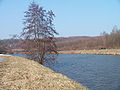
The Champagney water reservoir

The Haute-Saône Canal near Frahier
A canal bridge at Frahier
The Frahier harbor basin


Web links
- Information about the channel (French)
- The Beluga on the Haute-Saône Canal (German)
- Peter Greuter's page about the Canal (French)
- Free time on the canal (French)
See also
Individual evidence
- ↑ Le tronçon du canal définitivement fermé. Retrieved June 5, 2019 (FR-FR).