
Bermont
| Bermont | ||
|---|---|---|
.svg)
|
|
|
| region | Bourgogne-Franche-Comté | |
| Department | Territoire de Belfort | |
| Arrondissement | Belfort | |
| Canton | Châtenois-les-Forges | |
| Community association | Grand Belfort | |
| Coordinates | 47 ° 35 ' N , 6 ° 51' E | |
| height | 331-430 m | |
| surface | 2.74 km 2 | |
| Residents | 391 (January 1, 2017) | |
| Population density | 143 inhabitants / km 2 | |
| Post Code | 90400 | |
| INSEE code | 90011 | |
 Mairie Bermont |
||

Bermont (German obsolete Schoenberg ) is a French commune in the department Territoire de Belfort in the region Bourgogne Franche-Comté .
geography
Bermont is 362 m above sea level, about seven kilometers south of the city of Belfort (as the crow flies). The village extends in the area of the Burgundian Gate , slightly elevated on a plateau west of the wide valley plain of the Savoureuse opposite Sevenans, at the northeast foot of the Bois d'Oye.
The area of the 2.74 km² municipality covers a section of the gently undulating landscape in the area of the Burgundian Gate (Trouée de Belfort). The eastern border runs in the middle of the approximately one kilometer wide valley plain of the Savoureuse, which flows south and provides drainage to the Allan . The waterway of the Canal de la Haute-Saône , a branch of the Rhine-Rhône Canal, is also located in the valley floor .
From the valley level, which is an average of 340 m, the community area extends westward to the Bermont plateau. This is flanked in the north by the Bois des Camouchots and in the southwest by the Bois d'Oye . At the height of the Fort du Bois d'Oye , the highest point of Bermont is reached at 433 m. With a narrow tip, the community soil extends further west into the extensive forest of the Bois de Châtenois . The area around the Fort du Bois d'Oye is part of a military area.
The neighboring municipalities of Bermont are Dorans and Sevenans in the north, Trévenans in the east, Châtenois-les-Forges in the south and Brevilliers in the west.
history
Bermont is first mentioned in writing in 1147 under the name Bellemonte in a document of the Lanthenans Priory . Initially under the influence of the lords of Montbéliard, Bermont came under the sovereignty of the Habsburgs in the mid-14th century. At the height of the Bois d'Oye was the village of Oye , which had been destroyed by Swedish troops during the Thirty Years War in 1633 and was therefore abandoned. Together with the Sundgau , Bermont came to the French crown with the Peace of Westphalia in 1648. Since 1793 the village has belonged to the Haut-Rhin department , but in 1871 it remained as part of the Territoire de Belfort, unlike the rest of Alsace, in France. From the mid-1870s the Fort du Bois d'Oye was built, which is part of the fortification ring of Belfort. Since 1998, Bermont was initially part of the Communauté d'agglomération Belfortaine , which was merged into the Communauté d'agglomération Grand Belfort in 2017 .
Attractions
The church of St. Laurentius ( Saint-Laurent ) stands on a hill above the valley of the Savoureuse. Parts of the choir and the polygonal apse of the Romanesque church have been preserved. The Notre-Dame du Chêne chapel dates from 1841. Other sights include houses from the Renaissance period and the bridge of the Canal de la Haute-Saône over the Savoureuse.
See also: List of Monuments historiques in Bermont

- St. Laurentius Church

West side

inside view
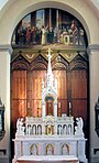
altar

organ


population
| year | Residents |
|---|---|
| 1962 | 110 |
| 1968 | 123 |
| 1975 | 174 |
| 1982 | 226 |
| 1990 | 234 |
| 1999 | 280 |
With 391 inhabitants (January 1, 2017), Bermont is one of the small communities in the Territoire de Belfort department. After the population in the first half of the 20th century was mostly in the range between 90 and 130 people, there has been a strong population growth since the beginning of the 1970s. Since then the number of inhabitants has almost tripled.
Economy and Infrastructure
Bermont was a village dominated by agriculture (arable farming, fruit growing and cattle breeding) well into the 20th century. In addition, there are now various local small businesses. In the meantime the village has turned into a residential community. Many workers are therefore commuters who do their work in the agglomerations of Belfort and Montbéliard .
The village is well developed in terms of traffic. It is close to the main road that leads from Belfort to Montbéliard. The nearest connection to the A36 motorway , which crosses the municipality, is around one kilometer away. Bermont is connected to Belfort by a bus line.
literature
- Le Patrimoine des Communes du Territoire de Belfort. Flohic Editions, Paris 1999, ISBN 2-84234-037-X , pp. 97-99.
Web links
Individual evidence
- ^ Topographical dictionary of Upper Alsace: containing the old and new place names on behalf of the industrial society of Mulhouse, published by Georg Stoffel; 1876