
Évette-Salbert
| Évette-Salbert | ||
|---|---|---|
.svg)
|
|
|
| region | Bourgogne-Franche-Comté | |
| Department | Territoire de Belfort | |
| Arrondissement | Belfort | |
| Canton | Valdoie | |
| Community association | Grand Belfort | |
| Coordinates | 47 ° 41 ′ N , 6 ° 48 ′ E | |
| height | 382-474 m | |
| surface | 9.16 km 2 | |
| Residents | 2,055 (January 1, 2017) | |
| Population density | 224 inhabitants / km 2 | |
| Post Code | 90350 | |
| INSEE code | 90042 | |
| Website | http://www.evettesalbert.fr/ | |
 Mairie Évette-Salbert |
||

Évette-Salbert is a French commune in the department Territoire de Belfort in the region Bourgogne Franche-Comté .
geography
Évette-Salbert is 397 m above sea level, about six kilometers north-northwest of the city of Belfort (as the crow flies). The village extends in the foothills of the Vosges , on the southwestern edge of the Giromagny basin, which extends between the Vosges, the hills of the Forêt de Roppe and the Montagne de Salbert, south of the Étang de Malsaucy. It is located in the Ballons des Vosges Regional Nature Park .
The area of the 9.16 km² municipal area includes a section in the area of the Vosges foothills. The main part of the area is occupied by the plain of the Giromagny basin, which lies at an average of 400 m. It consists mainly of arable and meadow land, but also shows some forest areas. The area is drained by the Verboté to the east to the Savoureuse . Along the rivers and in hollows there are numerous ponds that were once created for fish farming. The most important of these is the Étang de Malsaucy with an area of around 66 hectares. To the south, the terrain gradually rises to the Montagne de Salbert, but the municipal soil only extends to the edge of the forest. Here, at 474 m, the highest elevation of Évette-Salbert is reached.
The municipality of Évette-Salbert consists of different districts:
- Bas-Évette (395 m) south of the Étang de Malsaucy
- Le Haut-d'Évette (397 m) in the valley of the Verboté
- Salbert (420 m) at the northern foot of the Montagne de Salbert
- Thiamont (410 m) on the plateau on the northwest edge of the Montagne de Salbert
- La Forêt (398 m) at the western foot of the Montagne de Salbert
Neighboring municipalities of Évette-Salbert are Lachapelle-sous-Chaux and Sermamagny in the north, Valdoie in the east, Belfort , Essert and Châlonvillars in the south and Frahier-et-Chatebier and Errevet in the west.
history
Traces of a Neolithic settlement have been found in the municipality . Évette, which used to be called Weide in German, was first mentioned in a document in 1304. Salbert was first mentioned in 1347 as Saleberg . Initially under the influence of the Counts of Montbéliard , both villages belonged to the dominion of Rosemont. This came under the sovereignty of the Habsburgs in the middle of the 14th century. Together with the Sundgau , Évette and Salbert came to the French crown with the Peace of Westphalia in 1648. Since 1793 the villages belonged to the Haut-Rhin department , but in 1871 they remained as part of the Territoire de Belfort, unlike the rest of Alsace, in France.
In 1880, Évette was connected to the French rail network when the station was built on the Belfort-Vesoul line. The branch line from Évette to Giromagny was opened in 1883. Since 1938, however, this line has only been used to transport goods. Effective December 1, 1972, Évette and Salbert merged to form the twin municipality of Évette-Salbert. Since 1998, Évette-Salbert was initially a member of the Communauté d'Agglomération Belfortaine , which was merged into the Communauté d'agglomération Grand Belfort in 2017 .
Attractions
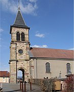
The Saint-Claude church was built between 1779 and 1781. At the same time the rectory next to it was built. The region around the Étang de Malsaucy is one of the natural sights and recreational areas with various recreational sports.
See also: List of Monuments historiques in Évette-Salbert
- Saint-Claude church in Évette-Salbert


population
| Population development | |
|---|---|
| year | Residents |
| 1962 | 841 |
| 1968 | 883 |
| 1975 | 1389 |
| 1982 | 1781 |
| 1990 | 2093 |
| 1999 | 2155 |
With 2055 inhabitants (January 1, 2017), Évette-Salbert is one of the medium-sized municipalities in the Territoire de Belfort. After the population in the first half of the 20th century had always been in the range between 750 and 850 people, there was strong population growth from the beginning of the 1970s to around 1990. During this time the number of inhabitants has almost tripled. Since 1990 only relatively small fluctuations have been observed.
Economy and Infrastructure
Until well into the 20th century, Évette-Salbert was mainly characterized by agriculture (arable farming, fruit growing and cattle breeding), fish farming and forestry. Today there are some small and medium-sized businesses. In the meantime, the village has also turned into a residential community. Many workers are therefore commuters who go to work in the Belfort agglomeration.
The village is located away from the major thoroughfares, but can be easily reached from the D465, which leads from Belfort to Giromagny. The closest connection to the A36 motorway is around nine kilometers away. Further road connections exist with Sermamagny, Valdoie, Frahier-et-Chatebier and Errevet.
literature
- Le Patrimoine des Communes du Territoire de Belfort. Flohic Editions, Paris 1999, ISBN 2-84234-037-X , p. 168.