Petite-Chaux
| Petite-Chaux | ||
|---|---|---|
|
|
||
| region | Bourgogne-Franche-Comté | |
| Department | Doubs | |
| Arrondissement | Pontarlier | |
| Canton | Frasne | |
| Community association | Lacs et Montagnes du Haut-Doubs | |
| Coordinates | 46 ° 42 ′ N , 6 ° 10 ′ E | |
| height | 955-1,286 m | |
| surface | 9.81 km 2 | |
| Residents | 143 (January 1, 2017) | |
| Population density | 15 inhabitants / km 2 | |
| Post Code | 25240 | |
| INSEE code | 25451 | |
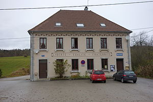
 Mairie Petite-Chaux |
||
Petite-Chaux is a French municipality with 143 inhabitants (as of January 1 2017) in Doubs in the region Bourgogne Franche-Comté .
geography
Petite-Chaux is located at 985 m above sea level, about 28 kilometers southwest of the city of Pontarlier (as the crow flies). The street line village extends in the Jura , in the longitudinal basin of the Val de Mouthe on the northern slope of the valley, between the heights of the Bois de Ban in the north and the Risoux in the south, near the border with Switzerland .
The area of the 9.81 km² municipal area covers a section of the French Jura. The landscape is characterized by parallel ridges and longitudinal hollows, which are oriented in the southwest-northeast direction according to the direction of the fold of the Jura in this region. The central part of the area is occupied by an approximately 1 km wide longitudinal basin that forms a syncline in geological and tectonic terms . The area is drained by the Cébriot to the northeast to the Doubs .
On its northwest side, the longitudinal basin of the Val de Mouthe is flanked by the wooded height of the Bois de Ban ( 1095 m ). With a narrow strip, the community area extends south into the partly wooded, partly pastureland area of the Risoux, on which the highest point of Petite-Chaux is reached at 1280 m. There are no surface rivers here because the rainwater seeps into the karstified subsoil. The municipality is part of the Upper Jura Regional Nature Park (French: Parc naturel régional du Haut-Jura ).
Petite-Chaux includes the hamlet of Vuillet ( 992 m ) in the Val de Mouthe north of the Cébriot and numerous individual farms. Neighboring municipalities to Petite-Chaux are Le Crouzet and Reculfoz in the north, Mouthe in the east and Chaux-Neuve in the south and west.
history
The area around Petite-Chaux was cleared and made arable in the 12th century. However, the actual settlement did not take place until the 14th century. In the Middle Ages, Petite-Chaux was part of the Mouthe domain. Together with Franche-Comté , the village came to France with the Peace of Nijmegen in 1678. A devastating fire in 1976 destroyed six houses, including the Musée de la Maison de Pleine Air. Today, Petite-Chaux is a member of the Lacs et Montagnes du Haut-Doubs municipal association .
Attractions
The village chapel Saint-Antide was built in 1681 and extensively restored at the end of the 20th century.
population
| Population development | |
|---|---|
| year | Residents |
| 1962 | 120 |
| 1968 | 114 |
| 1975 | 64 |
| 1982 | 77 |
| 1990 | 128 |
| 1999 | 129 |
| 2006 | 129 |
| 2016 | 145 |
With 143 inhabitants (January 1, 2017), Petite-Chaux is one of the smallest municipalities in the Doubs department. After the population had declined markedly in the first half of the 20th century (214 people were still counted in 1891), population growth has been recorded again since the beginning of the 1980s.
Economy and Infrastructure
Until well into the 20th century, Petite-Chaux was predominantly a village characterized by agriculture, in particular dairy and cattle breeding, as well as forestry. In addition, there are now some local small businesses, including a watchmaking company. Some workers are also commuters who work in the larger towns in the area.
The village is located off the major thoroughfares on the D437 departmental road, which leads from Saint-Laurent-en-Grandvaux to Pontarlier.
literature
- Le Patrimoine des Communes du Doubs. Volume 2, Flohic Editions, Paris 2001, ISBN 2-84234-087-6 , pp. 817-819.

