Jougne
| Jougne | ||
|---|---|---|

|
|
|
| region | Bourgogne-Franche-Comté | |
| Department | Doubs | |
| Arrondissement | Pontarlier | |
| Canton | Frasne | |
| Community association | Lacs et Montagnes du Haut-Doubs | |
| Coordinates | 46 ° 46 ' N , 6 ° 23' E | |
| height | 809-1,463 m | |
| surface | 29.03 km 2 | |
| Residents | 1,858 (January 1, 2017) | |
| Population density | 64 inhabitants / km 2 | |
| Post Code | 25370 | |
| INSEE code | 25318 | |
| Website | Jougne | |
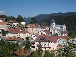
 View of Jougne |
||
Jougne is a French commune with 1,858 inhabitants (as of January 1, 2017) in the Doubs department in the Bourgogne-Franche-Comté region not far from the Swiss border.
geography
The place is on the road connection from Lausanne or Vallorbe to Besançon ( Route nationale 57 ). Above the town over the Col de Jougne pass , the watershed runs between the catchment areas of the Rhine and Rhone . The municipality is part of the Upper Jura Regional Nature Park (French: Parc naturel régional du Haut-Jura ).
history
Between the years 1875 and 1939 the village was on the railway line from Vallorbe to Pontarlier, built by the Chemin de fer de Jougne à Eclépens (JE) . In 1942 the route was canceled.
| Population development | ||||||||
| year | 1962 | 1968 | 1975 | 1982 | 1990 | 1999 | 2005 | 2016 |
| Residents | 744 | 815 | 858 | 866 | 1162 | 1298 | 1328 | 1839 |
Community partnerships
Jougne has a partnership with the Italian municipality of Buttigliera Alta in Piedmont .
literature
- Le Patrimoine des Communes du Doubs. Volume 2, Flohic Editions, Paris 2001, ISBN 2-84234-087-6 , pp. 805-808.
