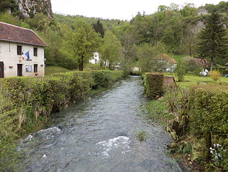
Cusancin
| Cusancin | ||
|
|
||
| Data | ||
| Water code | FR : U2420520 | |
| location | France , Bourgogne-Franche-Comte region | |
| River system | Rhône | |
| Drain over | Doubs → Saône → Rhône → Mediterranean | |
| source | in the parish of Cusance, 47 ° 19 ′ 19 ″ N , 6 ° 26 ′ 14 ″ E |
|
| Source height | approx. 375 m | |
| muzzle | opposite Baume-les-Dames in the Doubs Coordinates: 47 ° 20 ′ 29 ″ N , 6 ° 22 ′ 22 ″ E 47 ° 20 ′ 29 ″ N , 6 ° 22 ′ 22 ″ E |
|
| Mouth height | approx. 260 m | |
| Height difference | approx. 115 m | |
| Bottom slope | approx. 8.8 ‰ | |
| length | 13 km | |
| Left tributaries | Sesserant | |
| Right tributaries | Torrent des Alloz | |
|
left source river Cuse |
||
|
right source river Ance |
||
The Cusancin is a river in France that runs in the Doubs department in the Bourgogne-Franche-Comté region . It rises in the northwestern foothills of the Jura , in the municipality of Cusance and flows into the Doubs as a left tributary opposite Baume-les-Dames .
geography
The Cusancin rises near Cusance from the two large karst springs Source Noire (German “Black Source”) (location) and Source Bleue (German “Blue Source”) (location) . The two source rivers that arise there are named Cuse and Ance , from which the Cusancin is formed at their confluence .
Spring streams
The 300 m long, often more watery Cuse rises from a small cave in the rock. The Source Noire , or Source du Cusancin , is on the left side of the valley. The spring cave can dry up in dry times, so that the river only rises from small hillside springs a little further down the valley. The Source Bleue , a turquoise shimmering spring pot on the right side of the valley, is the source of the approximately 500 m long Ances . After a few hundred meters it takes up the torrent des Alloz stream, which has mostly fallen dry, and then joins the Cuse to the Cusancin. Both source streams operate a mill.
course
The Cusancin initially drains west through the approximately 150 meters deep valley of the Vallée de Cusance , then turns in several loops to the northeast and after 13 kilometers, opposite Baume-les-Dames, flows into the Doubs as a left tributary, which unites in this area Forms part of the Canal du Rhône au Rhin .
Tributaries
- Torrent des Alloz (right)
- Glaie Noire (left)
- Sesserant (left)


