
Auvernier
| Auvernier | ||
|---|---|---|
 |
||
| State : |
|
|
| Canton : |
|
|
| District : | No district division | |
| Municipality : | Milvignes | |
| Postal code : | 2012 | |
| former BFS no. : | 6401 | |
| Coordinates : | 557 432 / 202966 | |
| Height : | 433 m above sea level M. | |
| Area : | 1.69 km² | |
| Residents: | 1559 (December 31, 2012) | |
| Population density : | 922 inhabitants per km² | |
| Website: | www.auvernier.ch | |
| map | ||
|
||


Auvernier is a village and former political municipality in the district of Boudry in the canton of Neuchâtel in Switzerland . The former German name Avernach is no longer used today. On January 1, 2013, it merged with the municipalities of Bôle and Colombier to form the new municipality of Milvignes .
geography
Auvernier is 433 m above sea level. M. , four kilometers west-southwest of the canton capital Neuchâtel (linear distance ). The former winegrowing village extends at the southern foot of the Jura , near the shores of Lake Neuchâtel .
The area of the 1.7 km² municipal area includes a section on the north shore of Lake Neuchâtel. The communal soil extends from the narrow strip of shore northwards over the slope to the level of the terrace of Peseux and Corcelles-Cormondrèche. The highest point of Auvernier is at 530 m above sea level. M. at the edge of this terrace. In 1997, 46% of the municipal area was in settlements, 4% in forests and woodland, 48% in agriculture and a little less than 2% was unproductive land.
The Beauregard quarter above the train station belongs to Auvernier . Neuchâtel , Peseux , Corcelles-Cormondrèche and Colombier are neighboring municipalities of Auvernier .

population
With 1559 inhabitants (December 31, 2012) Auvernier is one of the medium-sized municipalities in the canton of Neuchâtel. Of the residents, 86.2% are French-speaking, 6.7% German-speaking and 2.2% Italian-speaking (as of 2000). The population of Auvernier has increased slowly but continuously since 1850 (677 inhabitants).
economy
Auvernier has been a traditional wine-growing and fishing community since the Middle Ages . The slopes in the vicinity of the village are optimally oriented towards the sun and are suitable for viticulture. Since 1888 Auvernier has been the seat of the cantonal viticulture school (today Service cantonale de viticulture). In the last few decades Auvernier has developed into a residential community with a high percentage of commuters who work mainly in neighboring Neuchâtel.
traffic
The community is very well developed in terms of transport. It is located on the main road 5 from Neuchâtel to Yverdon , which was relieved in 1977 with the opening of the motorway section of the A5 from Serrières to Boudry. In the area of the village, the motorway was laid in an open-cast tunnel. As part of the construction of the motorway, the landscape along the lakeshore underwent massive changes: around 17 hectares of land were raised and the bank redesigned with recreational facilities.
On November 7, 1859, the Yverdon – Neuchâtel line was opened with a station in Auvernier. On July 25, 1860, the Auvernier - Les Verrières line was inaugurated . This branches off the south foot line of the Jura to the west of Auvernier station . Overland line 5 of the Neuchâtel tram, opened in 1892, also has a stop in Auvernier.
history
Auvernier can look back on a very long tradition of settlement. In 1855 remains of pile dwellings were discovered on the edge of the lake and subsequently excavated. The Auvernier settlement is one of the most important prehistoric sites in Switzerland and gave its name to the Auvernier phase , a section of the later Swiss Neolithic . The place was probably from the 4th to the 1st millennium BC. Inhabited. In 1876 the Allée couverte of Auvernier a megalithic complex was discovered. Auvernier was also inhabited during Roman and Burgundian times. A statuette of Jupiter was found.
The village was first mentioned in a document in 1011 under the name Averniacum . The area then belonged to the Kingdom of Burgundy . During the 14th century, the Counts of Neuchâtel extended their power to Auvernier. From 1648 Neuchâtel was a principality and from 1707 it was linked to the Kingdom of Prussia through personal union. In 1806 the area was ceded to Napoleon I and came to the Swiss Confederation in the course of the Congress of Vienna in 1815 , whereby the kings of Prussia until the Neuchâtel trade in 1857 also remained princes of Neuchâtel. Auvernier belonged to Mairie La Côte until 1848 and since then has belonged to the Boudry district.
Attractions
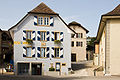
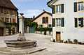
Auvernier has a picturesque townscape. The Reformed Church is in the upper part of the village. It was created through several alterations and enlargements of the chapel, which was built in 1478 and consecrated to Saint-Nicolas. Noteworthy is the so-called house of the Solothurn Citizens Hospital, built around 1530, with a stair tower. The Grand 'Rue, which connects the upper with the lower part of the village, is lined on both sides by town houses from the 16th and 17th centuries. To the west of the village is the castle flanked by two turrets, which was built in 1559 and expanded in the 17th century.
Parish hall

Grand'Rue
Port du vin

View east to the village

Gallery grave


Web links
- Official website of the municipality of Auvernier (French)
- Michel Egloff and Germain Hausmann: Auvernier. In: Historical Lexicon of Switzerland .
Boudry | Les Brenets | La Brévine | Bread plamboz | Le Cerneux-Péquignot | La Chaux-de-Fonds | La Chaux-du-Milieu | Corcelles-Cormondrèche | Cornaux | Cortaillod | La Côte-aux-Fées | Cressier | Tight | La Grande Béroche | Hauterive | Le Landeron | Lignières | Le Locle | Milvignes | Neuchâtel | Peseux | Les Planchettes | Les Ponts-de-Martel | Rochefort | La Sagne | Saint-Blaise | La Tène | Valangine | Val-de-Ruz | Val-de-Travers | Les Verrières
Former municipalities: Areuse | Auvernier | Les Bayards | Bevaix | Bôle | Boudevilliers | Boveresse | Bread lingerie | Bread dessus | Buttes | Cernier | Chézard-Saint-Martin | Coffrane | Colombier | Combes | La Coudre | Couvet | Dombresson | Engollon | Epagnier | Les Eplatures | Fenin | Fenin-Vilars-Saules | Fleurier | Fontainemelon | Fontaines | Fresens | Les Geneveys-sur-Coffrane | Gorgier | Les Hauts-Geneveys | Marin | Marin-Epagnier | Montalchez | Montmollin | Môtiers | Noiraigue | Le Pâquier | Plamboz | Saint-Aubin | Saint-Aubin-Sauges | Saint-Sulpice | Suction | Saules | Savagnier | Thielle-Wavre | Thielle | Travers | Vaumarcus | Vernéaz | Vilars | Villiers | Voëns-Maley | Wavre
Canton of Neuchâtel | Municipalities of the canton of Neuchâtel