Dombresson
| Dombresson | ||
|---|---|---|
| State : |
|
|
| Canton : |
|
|
| District : | No district division | |
| Municipality : | Val-de-Ruz | |
| Postal code : | 2056 | |
| former BFS no. : | 6475 | |
| Coordinates : | 563 626 / 213579 | |
| Height : | 742 m above sea level M. | |
| Area : | 12.77 km² | |
| Residents: | 1622 (December 31, 2012) | |
| Population density : | 127 inhabitants per km² | |
| Website: | www.dombresson.ch | |
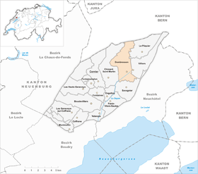
| map | ||
|
|
||
Dombresson was a municipality in the Val-de-Ruz district in the canton of Neuchâtel in Switzerland . On January 1, 2013, it merged with the municipalities of Boudevilliers , Cernier , Chézard-Saint-Martin , Coffrane , Engollon , Fenin-Vilars-Saules , Fontainemelon , Fontaines , Les Geneveys-sur-Coffrane , Les Hauts-Geneveys , Montmollin , Le Pâquier , Savagnier and Villiers to form the new municipality of Val-de-Ruz .
geography
Dombresson lies at 742 m above sea level. M. , nine kilometers north-northeast of the canton capital Neuchâtel (linear distance ). The village extends on the northeastern edge of the Val de Ruz basin in the Neuchâtel Jura , between the anticlines of the Mont d'Amin in the north and the Chaumont in the southeast.
The area of the 12.8 km² municipal area includes in its southern part the north-east corner of the agriculturally intensively used Val de Ruz basin, on both sides of the canalised Seyon brook . To the north, the municipality extends over several mountain ranges that belong to the Jura chain of Mont d'Amin. The ridge of Les Planches ( 1059 m above sea level ) forms the southern ridge , to the north the valley of Le Côty , the densely forested ridge Forêt du Côty , which is bordered to the west by the Klustal des Pertuis, the Combe Mauley and the Heights of La Joux du Plane . The highest point of Dombresson is 1245 m above sea level. M. in the Forêt du Côty. On the Jura heights there are extensive Jura high pastures with the typical mighty spruce trees , which either stand individually or in groups. In 1997, 5% of the municipal area was in settlements, 36% in forests and woodlands, 58% in agriculture and a little less than 1% was unproductive land.
Dombresson includes the hamlet of Les Vieux Prés ( 1030 m above sea level ) at the level of Les Planches, the scattered settlement La Joux du Plane ( 1180 m above sea level ) and numerous individual farms. Neighboring municipalities of Dombresson are Chézard-Saint-Martin , Savagnier , Villiers and Le Pâquier in the canton of Neuchâtel and Sonvilier in the canton of Bern .
population
With 1622 inhabitants (December 31, 2012) Dombresson is one of the medium-sized communities in the canton of Neuchâtel. 91.7% of the residents are French-speaking, 2.9% German-speaking and 1.7% Italian-speaking (as of 2000). Dombresson had 1282 inhabitants in 1920; the population sank to 963 by 1950, but has been increasing again since then.
economy
Until the 20th century, Dombresson was mainly an agricultural village. In the course of the 19th century, some watchmaking companies settled in the village . Today there are precision mechanics , mechanical engineering and some electronic industries in Dombresson . Agriculture is also still of great importance. While agriculture predominates in the Val de Ruz , cattle and dairy farming is practiced on the Jura Heights . In the last few decades Dombresson has developed into a residential community. Many workers are commuters and work in Neuchâtel or in La Chaux-de-Fonds .
traffic
The community is located on the cantonal road from Neuchâtel over the Col des Pontins to Saint-Imier . Dombresson is connected to the public transport network by the Neuchâtel - Cernier - Villiers bus line . From 1903 to 1948 Dombresson was served by the Les Hauts-Geneveys – Villiers tram. It was replaced by the Val de Ruz trolleybus , which in turn was replaced by buses in 1984.
history
The first written mention of the village took place in 1178 under the name Danbrizun , in 1228 the name Dombrecon appeared . The name goes back to the Latin Domus Bricii ( house of Bricius , a companion of St. Himerius). A treasure with 400 gold and silver coins from the time of the birth of Christ, discovered in 1824, indicates an early inspection and settlement of the municipality.
Dombresson belonged to the lordship of Valangin , which was partly subordinate to the Counts of Neuchâtel, partly to the Counts of Montbéliard and finally came to Neuchâtel in 1592. In 1531 the Reformation was introduced in the village at the behest of the city of Biel . From 1648 Neuchâtel was a principality and from 1707 it was linked to the Kingdom of Prussia through personal union. In 1806 the area was ceded to Napoleon I and came to the Swiss Confederation in the course of the Congress of Vienna in 1815 , whereby the kings of Prussia until the Neuchâtel trade in 1857 also remained princes of Neuchâtel.
Attractions
The current building of the reformed parish church Saint-Brice was created 1696–98. Only the church tower was taken over from the previous Romanesque building. The rectory was built in 1730.
Web links
- Official website of the municipality of Dombresson (French)
- Maurice Evard: Dombresson. In: Historical Lexicon of Switzerland .
Individual evidence


