
Colombier NE
| NE is the abbreviation for the canton of Neuchâtel in Switzerland and is used to avoid confusion with other entries of the name Colombier . |
| Colombier | ||
|---|---|---|
 |
||
| State : |
|
|
| Canton : |
|
|
| District : | No district division | |
| Municipality : | Milvignes | |
| Postal code : | 2013 | |
| former BFS no. : | 6406 | |
| Coordinates : | 556 155 / 201 894 | |
| Height : | 457 m above sea level M. | |
| Area : | 4.52 km² | |
| Residents: | 5547 (December 31, 2012) | |
| Population density : | 1227 inhabitants per km² | |
| Website: | www.colombier.ch | |
| map | ||
|
||


Colombier ([ kɔlɔ̃bje ], in the native Franco-Provencal dialect [ kolɔ̃ˈbiə ]) was a municipality in the district of Boudry in the canton of Neuchâtel in Switzerland . On January 1, 2013, it merged with the municipalities of Auvernier and Bôle to form the new municipality of Milvignes .
geography
Colombier is 457 m above sea level. M. , six kilometers west-southwest of the canton capital Neuchâtel (linear distance ). The village extends in a hollow at the southern foot of the Jura , near the shores of Lake Neuchâtel ; the old town center is slightly elevated on a molasse hill .
The area of the 4.5 km² municipal area comprises a narrow section on the north shore of Lake Neuchâtel. The communal soil extends from the bank, which forms the northernmost part of the Areuse alluvial plain , to the northwest over the Colombier basin and the Planeyse plateau, which is around 50 m above the lake, up the southern slope of the Jura and also includes the Cottendart forest . The highest point of Colombier is 660 m above sea level. M. below the Forêt de Dame Othenette . In 1997, 38% of the municipal area was in settlements, 20% in forests and woodland, 41% in agriculture and a little less than 1% was unproductive land.
The settlements Cottendart ( 570 m above sea level ) and Le Villaret ( 600 m above sea level ) on the southern slopes of the Jura belong to Colombier . The neighboring municipalities of Colombier are Boudry , Bôle , Rochefort , Corcelles-Cormondrèche and Auvernier .
population
With 5547 inhabitants (as of December 31, 2012) Colombier is one of the large municipalities in the canton of Neuchâtel. 86.4% of the residents are French-speaking, 4.5% German-speaking and 2.7% Italian-speaking (as of 2000). Colombier already had 2,051 inhabitants in 1900, a further significant increase in population has been recorded since around 1950, with particularly large growth rates being recorded during the 1960s.
economy
| Population development | |
|---|---|
| year | Residents |
| 1850 | 896 |
| 1900 | 2051 |
| 1950 | 2071 |
| 1960 | 2652 |
| 1970 | 4095 |
| 1980 | 4126 |
| 1990 | 4636 |
| 2000 | 4897 |
For a long time Colombier was mainly an agricultural place. Today, viticulture is still particularly important on the lower southern slopes of the Jura, which are optimally exposed to the sun. From the middle of the 18th century, many villagers worked in the indienne factories on the lower Areuse. In the course of the 19th century, some watchmaking companies were added. In the last few decades, Colombier has developed into a residential community from which many workers in Neuchâtel go to work. The village has relatively little industry. Supplying the barracks is one of the most important sources of income. In addition, Colombier is the location of a waste incineration plant (near Cottendart). In the secondary school center of Colombier, inaugurated in 1969, pupils from the parishes of the lower Areuse are taught.
traffic
The community is very well developed in terms of transport. It is located on the main road 5 from Neuchâtel to Yverdon . With the opening of the motorway section of the A5 from Serrières to Boudry in 1977, the town center was relieved of through traffic. On November 7, 1859, the Yverdon – Neuchâtel railway line was inaugurated with a train station in Colombier (on the municipality boundary west of the village). Overland line 5 of the Neuchâtel tram was opened in 1892 , it runs from Neuchâtel to Boudry and serves three stops in the municipality of Colombier. The Neuchâtel-Colombier airfield is located on the municipal border with Boudry .
Railway accident of March 22nd, 1871
On March 22, 1871, as a result of incorrectly setting the switches, a military extra train with members of the Bourbaki army to be interned collided with a parked freight train consisting of 22 coal wagons and a baggage car. A platoon leader and 22 internees died and 72 were injured. It was the second of three trains that were supposed to bring soldiers interned in Solothurn to Les Verrières. The train with 1,025 men left Solothurn at 5 p.m. and crashed in Colombier at around 9 p.m.
The soldiers killed were buried on March 24, 1871 in the Colombier cemetery, where a memorial was later erected.
history


Colombier can look back on a very long tradition of settlement. Remains of settlements from the Neolithic and Bronze Ages have been found along the lake shore . The area was also inhabited during the Roman era , and on the site of today's castle there was a spacious Roman villa, which was expanded into a palace-like mansion from the 1st to the 3rd century. A cemetery dates from the time of the Merovingians .
The first written mention of Colombier under the name Columbier goes back to the year 1228. Since the Middle Ages , Colombier formed its own rule, which included the Areuse settlement (now part of Boudry), parts of Bôle and Bevaix and some properties in more distant areas. The lords of Colombier were vassals of the Counts of Neuchâtel. By marriage, the dominion came in 1488 to the de Chauvirey family from Franche-Comté and in 1513 to Johann Jakob von Wattenwyl , who introduced the Reformation . It was not until 1564 that the Counts of Neuchâtel bought the rights to rule. From 1648 Neuchâtel was a principality and from 1707 it was linked to the Kingdom of Prussia through personal union. In 1806 the area was ceded to Napoleon I and came to the Swiss Confederation in the course of the Congress of Vienna in 1815 , whereby the kings of Prussia until the Neuchâtel trade in 1857 also remained princes of Neuchâtel. Colombier was the seat of a mairie until 1832, after which it belonged to the Mairie La Côte until 1848 and since then to the Boudry district.
post Office

The first traces of an actual mail depot in Colombier go back to 1811 (mail depositing single-line bar stamp in gray, black and red). From 1836 there was an official post office (with a double-circle stamp), i.e. more than 10 years before the Swiss Post was founded. Due to the development, it received the status of a second class post office in 1894. From its opening until 1912, the post office was located on Bahnhofstrasse, then until 1951 (from 1925 as a post office) in the parish hall, which rented premises to the postal administration. Although this central location was ideal, it will soon be necessary to look for a new location due to the lack of space. After several unsuccessful attempts, the post office bought a house on rue du Collège. However, this location soon proved to be problematic as various conflicts arose over the use of the premises. Therefore, a few years later, new discussions started with the community about the construction of a new building. Due to financial problems, the proposal of the postman at the time, Maurice Perdrizat, was accepted to build a new building which, in addition to the post office, also includes 17 condominiums. After two years of construction, the new post office on Rue du Verger was inaugurated in April 1973: it occupies an area of 600 m² (5 counters and 176 post boxes). The current post office (2019) is still at the same location and has letter, parcel and payment services.
Attractions
A first castle was probably built in the 11th to 13th centuries. Today's palace complex shows buildings of different ages and styles. The oldest part is the southeast corner with buildings in Gothic styles that were built in the 15th and 16th centuries. The entrance tower dates from 1543. There were further redesigns in the 17th and 19th centuries, when the castle courtyard served as a parade and parade ground. In the 18th century it served as George Keith's summer palace . From 1824 barracks were set up in the castle and in the surrounding buildings , which still exist today and houses the Infantry Officers School 1 and the Infantry Recruit School 5. Today the castle also houses a military museum and an indienne museum. The two large halls of the old castle wing, the armory and the knight's hall, house two monumental painting cycles by the Neuchâtel painter Charles L'Eplattenier . Another unexecuted mural draft by the same painter is kept in an officers' office at the same location.
The reformed church is a classicist building from 1828–1829. Numerous town houses from the 18th century have been preserved in the old town center. Le Pontet is a manor house that was built in the 17th century. The writer Isabelle de Charrière lived there in the 18th century . Other important country houses in the vicinity include Vaudijon (built 1800–1807 in Empire style), Le Bied, La Mairesse, Cottendart and Sombacour.
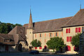
Chateau
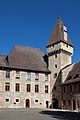
Chateau
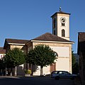
Temple

Chemin de Notre Dame
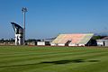
Stade

Tram No. 5

Le Pontet


Personalities
- Isabelle de Charriere , writer of the Enlightenment , lived on the estate Le Pontet
- David de Chaillet , Reformed pastor, promoter of the Neuchâtel Enlightenment
- Jonas de Gélieu (1740–1827), reformed pastor and beekeeper, died in Colombier
- Salomé de Gélieu (1742–1820), educator and tutor at European royal courts, died in Colombier
- Esther de Gélieu (1757–1817), teacher, headmistress and educator, died in Colombier
- Yvan Moscatelli (born February 15, 1944 in Borgosesia ), painter, draftsman, screen printer, glass painter
Web links
- Official website of the municipality of Colombier (French)
- Germain Hausman: Colombier (NE). In: Historical Lexicon of Switzerland .
- Aerial photos
- Documentation of the monumental paintings at Colombier Castle on mural.ch
Individual evidence
- ↑ Nicolas Pépin, Colombier NE (Boudry) in: Dictionnaire toponymique des communes suisses - Lexicon of Swiss community names - Dizionario toponomastico dei comuni svizzeri (DTS | LSG) , Center de dialectologie, Université de Neuchâtel, Verlag Huber, Frauenfeld / Stuttgart / Vienna 2005 , ISBN 3-7193-1308-5 and Éditions Payot, Lausanne 2005, ISBN 2-601-03336-3 , p. 254.
- ↑ Platoon leader and 22 internees death, 72 injured: Paul Winter Schweizer Bahnen under flags, page 26
- ↑ Walter Moser; The interned Bourbaki soldiers of the French Eastern Army in the city of Solothurn February and March 1871 in Yearbook for Solothurn History Volume 70. Page 384, doi : 10.5169 / seals-325170
- ↑ Post structures - PTT archive. Retrieved September 1, 2019 .
- ^ Pierre-André Delachaux / Aglaja Kempf: Yvan Moscatelli. In: Sikart (status: 2006) , accessed January 22, 2016.
Boudry | Les Brenets | La Brévine | Bread plamboz | Le Cerneux-Péquignot | La Chaux-de-Fonds | La Chaux-du-Milieu | Corcelles-Cormondrèche | Cornaux | Cortaillod | La Côte-aux-Fées | Cressier | Tight | La Grande Béroche | Hauterive | Le Landeron | Lignières | Le Locle | Milvignes | Neuchâtel | Peseux | Les Planchettes | Les Ponts-de-Martel | Rochefort | La Sagne | Saint-Blaise | La Tène | Valangine | Val-de-Ruz | Val-de-Travers | Les Verrières
Former municipalities: Areuse | Auvernier | Les Bayards | Bevaix | Bôle | Boudevilliers | Boveresse | Bread lingerie | Bread dessus | Buttes | Cernier | Chézard-Saint-Martin | Coffrane | Colombier | Combes | La Coudre | Couvet | Dombresson | Engollon | Epagnier | Les Eplatures | Fenin | Fenin-Vilars-Saules | Fleurier | Fontainemelon | Fontaines | Fresens | Les Geneveys-sur-Coffrane | Gorgier | Les Hauts-Geneveys | Marin | Marin-Epagnier | Montalchez | Montmollin | Môtiers | Noiraigue | Le Pâquier | Plamboz | Saint-Aubin | Saint-Aubin-Sauges | Saint-Sulpice | Suction | Saules | Savagnier | Thielle-Wavre | Thielle | Travers | Vaumarcus | Vernéaz | Vilars | Villiers | Voëns-Maley | Wavre
Canton of Neuchâtel | Municipalities of the canton of Neuchâtel