
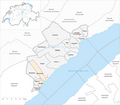
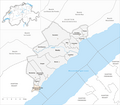
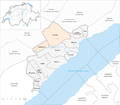
Boudry district
| District de Boudry | |
|---|---|
| Basic data | |
| Country: |
|
| Canton : |
|
| Main town : | Boudry |
| Area : | 105.46 km² |
| Residents: | 40,701 (December 31, 2017) |
| Population density : | 386 inhabitants per km² |
| map | |
 |
|
The District de Boudry was a district of the Canton of Neuchâtel in Switzerland until December 31, 2017 .
The following communities belonged to the district (as of January 1, 2016):
| coat of arms | Name of the parish | Population (December 31, 2017) |
Area in km² |
Inhabitant per km² |
|---|---|---|---|---|
|
|
Bevaix | 3784 | 10.70 | 354 |
|
|
Boudry | 6124 | 16.76 | 365 |
|
|
Corcelles-Cormondrèche | 4740 | 4.85 | 977 |
|
|
Cortaillod | 4774 | 3.68 | 1297 |
|
|
Fresens | 252 | 1.59 | 158 |
|
|
Gorgier | 2021 | 13.99 | 144 |
|
|
Milvignes | 9008 | 8.78 | 1026 |
|
|
Montalchez | 240 | 6.40 | 38 |
|
|
Peseux | 5825 | 3.39 | 1718 |
|
|
Rochefort | 1266 | 25.85 | 49 |
|
|
Saint-Aubin-Sauges | 2399 | 7.70 | 312 |
|
|
Vaumarcus | 268 | 1.77 | 151 |
| Total (12) | 40,701 | 105.46 | 386 | |
Changes in the community
Municipalities until 1887
Municipalities until 1965

Municipalities until 2012
Municipalities until 2015


- 1870: Areuse and Boudry → Boudry merged
- 1875: Merger of Vaumarcus and Vernéaz → Vaumarcus-Vernéaz
- 1888: Merger of Saint-Aubin and Sauges → Saint-Aubin-Sauges
- 1966: Change of name from Vaumarcus-Vernéaz → Vaumarcus
- 2013: merger of Auvernier , Bôle and Colombier → Milvignes
- 2016: Fusion Bread-Lingerie , Rochefort → Rochefort
Web links
Commons : Boudry district - collection of pictures, videos and audio files
Individual evidence
- ↑ Standard area statistics - municipalities according to four main areas (15.12.2017) of the Federal Statistical Office (FSO)
Former districts of the canton of Neuchâtel