
Les Bayards
| Les Bayards | ||
|---|---|---|
 |
||
| State : |
|
|
| Canton : |
|
|
| District : | No district division | |
| Municipality : | Val-de-Travers | |
| Postal code : | 2127 | |
| former BFS no. : | 6501 | |
| Coordinates : | 529772 / 196 589 | |
| Height : | 980 m above sea level M. | |
| Area : | 19.15 km² | |
| Residents: | 369 (December 31, 2007) | |
| Population density : | 19 inhabitants per km² | |
| Website: | www.les-bayards.com | |
 Quartier du Milieu |
||
| map | ||
|
||


Until December 31, 2008, Les Bayards was a municipality in the Val-de-Travers district of the canton of Neuchâtel in Switzerland .
Since January 1, 2009 Les Bayards belongs together with Boveresse , Buttes , Couvet , Fleurier , Môtiers , Noiraigue , Saint-Sulpice and Travers merged to Val-de-Travers .
geography
Les Bayards is 980 m above sea level. M. , 32 km west-southwest of the canton capital Neuchâtel (linear distance). The village extends in a hollow and on the adjoining slope slightly to the south on the northern side of the high valley Vallon de Verrières in the Neuchâtel Jura .
The area of the 19.2 km² former municipal area includes the easternmost section of the Vallon de Verrières in the south, whose valley floor is relatively narrow here at 930 m above sea level. M. lies. To the south of the valley, the area extends over the wooded slope of La Côtière to the anticline of the Montagne de Buttes (up to 1245 m above sea level ). To the north of the Vallon de Verrières, the communal soil extended over the terrace of Les Bayards and the height of Le Cernil in the westernmost part of the Vallée de la Brévine . A narrow tip reached further north over the Grosse Prise forest height ( highest point of Les Bayards at 1258 m above sea level ) to the ridge of La Côte du Cerf ( 1210 m above sea level ), both of which belong to the Larmont anticline . At various places in the former municipal area there are extensive Jura high pastures with the typical mighty spruce trees , which either stand individually or in groups. In 1997, 3% of the municipal area was accounted for by settlements, 51% for forests and woodlands and 46% for agriculture.
Les Bayards consists of the two villages Grand Bayard ( 976 m above sea level in the hollow) and Petit Bayard ( 1032 m above sea level on the slope). Les Bayards included the hamlet of Haut de la Tour ( 935 m above sea level ) in the Vallon de Verrières, Les Places ( 1020 m above sea level ) above Grand Bayard, Le Cernil ( 1174 m above sea level ) on the Altitude at the transition to the Vallée de la Brévine, Les Jordan ( 1056 m above sea level ) and Les Prises ( 1075 m above sea level ), both remote in the southwestern Vallée de la Brévine, as well as numerous individual farms scattered across the Jura heights. Neighboring communities of Les Bayards were Les Verrières , Buttes , Saint-Sulpice and La Brévine in the canton of Neuchâtel and Hauterive-la-Fresse and Les Alliés in neighboring France .

population
With 372 inhabitants (at the end of 2006), Les Bayards was one of the small communities in the canton of Neuchâtel. 97.2% of the residents are French-speaking and 2.8% German-speaking (as of 2000). After 1880 (1020 inhabitants) the population of Les Bayards decreased by more than two thirds until the village only had 301 inhabitants in 1990, since then a stagnation or a slight increase has been recorded.
economy
Les Bayards is still a predominantly agricultural village, with cattle breeding , dairy farming and cheese making predominant. Forestry and wood processing in a sawmill are also part of the population's occupation. At the end of the 18th century, lace making and watchmaking developed . The former disappeared again in the 19th century, while watchmaking was still important until the first half of the 20th century. Outside the primary sector there are now jobs in local small businesses. However, many employed people are commuters who work in the Val de Travers .
traffic
The former municipality is very well developed in terms of traffic. It is around 1 kilometer from the main road that connects Neuchâtel via the Les Verrières border crossing with Pontarlier in France. The PostBus course from Fleurier to Les Verrières, which partly goes to Pontarlier, connects Les Bayards to the public transport network. Another course operates on the route from Les Bayards to La Brévine.
history

The first written mention of the place took place in 1284 under the name Bayar . Later names are Boyhart (1344), Baiart (1373) and Beart (1400). Les Bayards was under the jurisdiction of Kastlanei Val-de-Travers from the 14th century until 1848. The Bayard Tower, the former customs post on the road through the Vallon de Verrières, fell into disrepair in the 17th century. The county of Neuchâtel held sovereignty over the area. From 1648 Neuchâtel was a principality and from 1707 it was linked to the Kingdom of Prussia through personal union. In 1806 the area was ceded to Napoleon I and came to the Swiss Confederation in the course of the Congress of Vienna in 1815 , whereby the kings of Prussia until the Neuchâtel trade in 1857 also remained princes of Neuchâtel. On the Le Cernil pass, the Auberge du Grand Frédéric still reminds us of Neuchâtel's Prussian past. The two villages Grand Bayard and Petit Bayard belonged to the entire municipality of Les Verrières until 1878 . In 1888 the villages merged to form the political municipality of Les Bayards.
Attractions
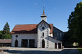
The Reformed Church of Les Bayards was built in 1677. From 1712 to 1969, Les Bayards formed an independent parish, since then it has been united with the parish of Les Verrières. In the villages there are still numerous typical farmhouses of the Upper Jurassic.
photos

Church (1677)
Chapelle (community hall)
school

Les Bayards train station


Personalities
- Jonas de Gélieu (1740–1827), reformed pastor and beekeeper, born in Les Bayards
- Salomé de Gélieu (1742–1820), educator and tutor at European royal courts, born in Les Bayards
literature
- Jean Courvoisier: The Art Monuments of the Canton of Neuchâtel, Volume III: Les districts du Valde-Travers, du Val-de-Ruz, du Locle et de La Chaux-de-Fonds. (= Art Monuments of Switzerland. Volume 56). Edited by the Society for Swiss Art History GSK. Bern 1968.
Web links
- Eric-André Klauser: Bayards, Les. In: Historical Lexicon of Switzerland .
Boudry | Les Brenets | La Brévine | Bread plamboz | Le Cerneux-Péquignot | La Chaux-de-Fonds | La Chaux-du-Milieu | Corcelles-Cormondrèche | Cornaux | Cortaillod | La Côte-aux-Fées | Cressier | Tight | La Grande Béroche | Hauterive | Le Landeron | Lignières | Le Locle | Milvignes | Neuchâtel | Peseux | Les Planchettes | Les Ponts-de-Martel | Rochefort | La Sagne | Saint-Blaise | La Tène | Valangine | Val-de-Ruz | Val-de-Travers | Les Verrières
Former municipalities: Areuse | Auvernier | Les Bayards | Bevaix | Bôle | Boudevilliers | Boveresse | Bread lingerie | Bread dessus | Buttes | Cernier | Chézard-Saint-Martin | Coffrane | Colombier | Combes | La Coudre | Couvet | Dombresson | Engollon | Epagnier | Les Eplatures | Fenin | Fenin-Vilars-Saules | Fleurier | Fontainemelon | Fontaines | Fresens | Les Geneveys-sur-Coffrane | Gorgier | Les Hauts-Geneveys | Marin | Marin-Epagnier | Montalchez | Montmollin | Môtiers | Noiraigue | Le Pâquier | Plamboz | Saint-Aubin | Saint-Aubin-Sauges | Saint-Sulpice | Suction | Saules | Savagnier | Thielle-Wavre | Thielle | Travers | Vaumarcus | Vernéaz | Vilars | Villiers | Voëns-Maley | Wavre
Canton of Neuchâtel | Municipalities of the canton of Neuchâtel