
Val-de-Travers district
| District du Val-de-Travers | |
|---|---|
| Basic data | |
| Country: |
|
| Canton : |
|
| Main town : | Môtiers |
| Area : | 166.44 km² |
| Residents: | 11,898 (December 31, 2017) |
| Population density : | 71 inhabitants per km² |
| map | |
 |
|
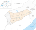
The District du Val-de-Travers was a district of the Canton of Neuchâtel in Switzerland until December 31, 2017 . The district is made up of the Val de Travers , through which the Areuse flows, the Vallon des Verrières and the surrounding Jura hills.
The following communities belonged to the district (as of January 1, 2016) :
| coat of arms | Name of the parish | Population (December 31, 2017) |
Area in km² |
Inhabitant per km² |
|---|---|---|---|---|
|
|
La Cote-aux-Fées | 435 | 12.83 | 34 |
|
|
Les Verrières | 718 | 28.87 | 25th |
|
|
Val-de-Travers | 10,745 | 124.74 | 86 |
| Total (3) | 11,898 | 166.44 | 71 | |
history
The valley is particularly famous for its absinthe production, which was illegal from 1910 until the ban was lifted in 2005. Other branches of industry located in Val-de-Travers include chocolate and watch manufacturing . The La Presta asphalt mines were in operation from 1712 to 1986 and can now be visited as part of a museum.
On April 3, 2007, the municipal parliaments of all the municipalities in the district unanimously decided to merge the eleven municipalities of the Val-de-Travers district. The proposal for the merger was submitted to the voters on June 17, 2007. However, since the voters of the municipalities of Les Verrières and La Côte-aux-Fées have spoken out against the merger, the merger could not take place for the time being. The approving municipalities worked out a new project, which was approved on February 23, 2008 by the voters of the canton of Neuchâtel. On January 1, 2009, the new municipality of Val-de-Travers was founded from 9 municipalities .
Through December 31, 2008, the borough's common landscape was as follows:
| Name of the parish | Population (December 31, 2007) |
Area in km² |
Inhabitant per km² |
|---|---|---|---|
| Boveresse | 392 | 12.90 | 30th |
| Buttes | 601 | 18.20 | 33 |
| Couvet | 2755 | 16.41 | 168 |
| Fleurier | 3518 | 7.74 | 455 |
| La Cote-aux-Fées | 469 | 12.83 | 37 |
| Les Bayards | 369 | 19.15 | 19th |
| Les Verrières | 669 | 28.67 | 23 |
| Môtiers | 825 | 6.42 | 129 |
| Noiraigue | 506 | 6.38 | 79 |
| Saint-Sulpice | 644 | 13.09 | 49 |
| Traverses | 1226 | 24.65 | 50 |
| Total (11) | 11,974 | 166.44 | 72 |
Changes in the community
Municipalities until 2008

- 2009: Fusion Boveresse , Buttes , Couvet , Fleurier , Les Bayards , Môtiers , Noiraigue and Travers → Val-de-Travers
Web links
Individual evidence
- ↑ a b Standard area statistics - municipalities according to four main areas (15.12.2017) of the Federal Statistical Office FSO