
Sainte-Croix VD
| VD is the abbreviation for the canton of Vaud in Switzerland and is used to avoid confusion with other entries of the name Sainte-Croix . |
| Sainte-Croix | |
|---|---|
 |
|
| State : |
|
| Canton : |
|
| District : | Jura north vaudois |
| BFS no. : | 5568 |
| Postal code : | 1450 Sainte-Croix 1454 L'Auberson |
| UN / LOCODE : | CH SCX (Sainte Croix) |
| Coordinates : | 528 545 / 186041 |
| Height : | 1086 m above sea level M. |
| Height range : | 594–1558 m above sea level M. |
| Area : | 39.47 km² |
| Residents: | 4863 (December 31, 2018) |
| Population density : | 123 inhabitants per km² |
| Website: | www.sainte-croix.ch |
 Sainte-Croix |
|
| Location of the municipality | |
  |
|
Sainte-Croix is a municipality in the Jura-Nord vaudois district in the canton of Vaud in Switzerland .
geography
Sainte-Croix is 1086 m above sea level. M. , 11 km west-northwest of the district capital Yverdon-les-Bains (linear distance). The municipality extends in a hollow on the south side of the Col des Etroits pass , in the headwaters of the Arnon in the Vaud Jura between the Aiguilles de Baulmes in the southwest and the Chasseron in the northeast.

The 39.4 km² municipal area covers a section of the Vaudois High Jura. The eastern part of the area lies in the headwaters of the Arnon, in which the moorland of La Sagne is also located. The Arnon flows through the narrow and steep gorge Gorges de Covatanne down into the Swiss plateau . The southern municipal boundary runs on the ridge of the Aiguilles de Baulmes (at 1,559 m above sea level, the highest elevation of Sainte-Croix) and the Mont de Baulmes . The basin of Sainte-Croix is closed in the west by the ridge of Mont des Cerfs ( 1273 m above sea level ), in the north by the Cochet ( 1483 m above sea level ). At these heights there are extensive Jura high pastures with the typical mighty spruce trees , which either stand individually or in groups. The western and northern parts of the municipality are in the catchment area of the Areuse . Here a plateau stretches out, which is criss-crossed by several smaller valleys and hollows. In the hollows there are some moor areas, including the Mouille de la Vraconnaz , which is under nature protection . The area is drained by the Noiraigue , which flows through the deeply cut Vallon de Noirvaux to the northeast in the direction of the Val de Travers . In the extreme northeast of the municipal area, the nature reserve is La Dénériaz , into the Chasseron- anticline deepened Ausräumungskessel that of the Roches Blanches , the Chasseron and the Petites Roches flanked. In 1997, 7% of the municipal area was settled, 48% forest and woodland, 43% agriculture and a little less than 2% was unproductive land.
Numerous hamlets and settlements belong to Sainte-Croix: Le Château de Sainte-Croix ( 990 m above sea level ) on a promontory over the Gorges de Covatanne, La Villette ( 925 m above sea level ), Chez Jaccard ( 1020 m above sea level) . M. ), Les Replans ( 1140 m above sea level ) and Petites Roches Dessus ( 1130 m above sea level ) on the southern slope of the Cochet, Culliairy ( 1037 m above sea level ) and La Sagne ( 1037 m above sea level . ) in the headwaters of the Arnon, La Gittaz Dessous ( 1235 m above sea level ) and La Gittaz Dessus ( 1280 m above sea level ) on the ridge north of the Aiguilles de Baulmes, the long street- lined village of L'Auberson ( 1100 m above sea level) M. ), Les Grangettes ( 1118 m above sea level ), Prize Perrier ( 1092 m above sea level ) and La Chaux ( 1086 m above sea level ) on the plateau west of the Col des Etroits, Mouille Mougnon ( 1040 m above sea level ) above sea level ) on the Noiraigue stream and La Vraconnaz ( 1109 m above sea level ) on the eastern edge of the moorland Mouille de la Vraconnaz. Furthermore, numerous individual farms belong to Sainte-Croix, which are widely scattered on the Jura heights. The neighboring municipalities of Sainte-Croix are Baulmes , Vuiteboeuf , Bullet and Fiez in the canton of Vaud, La Côte-aux-Fées in the canton of Neuchâtel and Les Fourgs and Les Hôpitaux-Vieux in neighboring France .
population
| Population development | |
|---|---|
| year | Residents |
| 1850 | 3541 |
| 1900 | 5914 |
| 1910 | 5190 |
| 1930 | 6340 |
| 1950 | 6575 |
| 1960 | 6925 |
| 1970 | 6240 |
| 1980 | 4543 |
| 1990 | 4321 |
| 2000 | 4333 |
With 4863 inhabitants (as of December 31, 2018), Sainte-Croix is one of the medium-sized municipalities in the canton of Vaud. 90.3% of the residents are French-speaking, 2.2% German-speaking and 2.2% Italian-speaking (as of 2000). The population of Sainte-Croix rose sharply in the second half of the 19th century and during the 1920s. The peak was reached around 1960 with almost 7,000 inhabitants. As a result of the economic crisis in the 1970s, there was massive emigration, so that in 1980 almost 30% fewer inhabitants were counted than a decade earlier. The population loss has continued in recent years, albeit to a much lesser extent than before.
economy
Sainte-Croix developed into an industrial community as early as the first half of the 18th century. At first the mining of iron ore and iron smelting were of particular importance. But lace was soon added and, around 1740, watchmaking , which was initially done at home. The watch industry led to the first major economic boom in Sainte-Croix. However, a time of crisis around 1860 brought the manufacture of watch components to a practical standstill. At the same time, lace making also disappeared. Precision mechanics stepped into the breach: the first factory for musical boxes was founded in 1814 . The still existing Reuge company followed in 1865. This branch of industry flourished around 1880 with the opening of further factories. Later the manufacture of phonographs and gramophones also became important. After the global economic crisis , precision mechanics concentrated on the production of office and accounting machines ( Hermes ), film projectors, cameras ( Paillard-Bolex ), radios and pocket lighters ( Thorens ). Another crisis that peaked in the mid-1970s resulted in the closure of numerous businesses and a population loss of over 30% within two decades.
Today electronics is the main industry in Sainte-Croix. Agriculture , especially cattle breeding and dairy farming , plays an important role in the hamlets .
The community gained fame throughout Switzerland in 1999 with the start of the Swiss TV soap Lüthi und Blanc , whose strand in western Switzerland is located in Sainte-Croix.
tourism
From around 1850, Sainte-Croix developed into a holiday and mountain health resort. Today it is also a popular destination for hiking. Several ski lifts are available on the slope of the Cochet for winter sports. The extensive plateaus are ideal for cross-country skiing .
In 1922 the artist "RH" created a poster for Sainte-Croix and Les Rasses in which the possibilities of winter sports at 3960 ft. Altitude in the "Swiss Jura" were pointed out.
Sainte-Croix is home to several museums, including the Musée industriel (opened in 1872) and the Musée CIMA des Center international de la mécanique d'art (for music boxes and jukeboxes), which was founded in 1985. The Musée Baud has been located in L'Auberson since 1955 and has music boxes on display.
traffic
The community is very well developed in terms of transport. It is located on the main road from Yverdon over the Col des Etroits to Pontarlier in France. At the pass crossing, the road branches off to Fleurier . On November 27, 1893, the narrow-gauge railway Chemin de fer Yverdon-Ste-Croix was put into operation. The PostBus courses to L'Auberson, Bullet and Buttes (via La Côte-aux-Fées) provide for the fine distribution in public transport .
history
In Roman times , the Yverdon-Pontarlier road ran through the municipality. However, this connection later became less important than the Orbe-Pontarlier road over the Jougne pass . In the early Middle Ages , the area around Sainte-Croix belonged to Burgundy . At that time it was still uninhabited and next to the pass road it formed an impenetrable wilderness. The reclamation took place in the 12th century, probably by the monks of the Benedictine priory in Baulmes . The first settlement in the region was La Villette. Sainte-Croix is 1177 in a document of Pope Alexander III. first mentioned as Sancta Crux .
To secure the road over the Col des Etroits and to defend against Hugues de Châlons, the Lords of Grandson built a castle in 1315 near La Villette at the narrow point of the Gorges de Covatanne, the Château de Sainte-Croix. In return, Hugues de Châlons built the Franc Castel in 1319. After the Swiss victory over Charles the Bold in the Battle of Grandson (1476), the borders in the Sainte-Croix area were moved to the west. The plateaus around L'Auberson have been used by the farmers in the Central Plateau as pastures for the pasturing of the herds from that time. At that time there were only individual and only temporarily inhabited settlements on the site of today's villages. After 1536, when the region fell to Bern and finally came under the Bailiwick of Grandson, which was under the common rule of Bern and Friborg , permanent settlements were established. In 1744 almost all the houses in Sainte-Croix fell victim to a village fire. After the collapse of the Ancien Régime , Sainte-Croix belonged to the canton of Léman from 1798 to 1803 during the Helvetic Republic, which then became part of the canton of Vaud when the mediation constitution came into force .
Attractions
The church of Sainte-Croix and the rectory were rebuilt after the fire around 1750; since then there have been several restorations. In Le Château de Sainte-Croix there are still the ruins of the former fortress.
On a slope between Sainte-Croix and Vuiteboeuf runs the most important preserved medieval road system in Switzerland with deepened wheel tracks. More than 20 wheel tracks are visible, especially in the upper section. The channels are sunk around 20 cm into the subsoil and mostly run parallel. Gauges of 1.09, 1.12 and 1.15 m can be observed. In some places there are steps for the draft animals. Next to the fairways, the wagoner's tracks are visible. For a long time the road network was thought to be Roman. However, new research has shown that the driveway was in use between the 14th and 18th centuries. In view of its economic importance for the salt transport from Franche-Comté at the time of the Bernese rule, the network of trails was improved and adapted several times. From 1760 a new, longer and less steep driveway was built, which replaced today's cantonal road in 1838.
meteorite
In 1988, a 4.8 gram iron meteorite type IIIAB was found at a campsite under the official name Ste. Croix registered.
photos
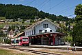
railway station
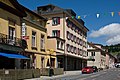
Rue Neuve

Avenue-des-alpes

Collège de la Poste

Center sportif

Temple


literature
- F. Mottas: De la plaine de l'Orbe en Franche-Comté: voie romaine et chemin saunier . In Archeology of Switzerland 9, 1986, 3, pp. 124-134.
Web links
- Official website of the commune of Sainte-Croix (French)
- Chantal Lafontant: Sainte-Croix (municipality). In: Historical Lexicon of Switzerland .
- Aerial photography
Individual evidence
- ↑ Permanent and non-permanent resident population by year, canton, district, municipality, population type and gender (permanent resident population). In: bfs. admin.ch . Federal Statistical Office (FSO), August 31, 2019, accessed on December 22, 2019 .
- ↑ History - Reuge. In: reuge.com. Retrieved July 14, 2015 .
- ↑ Frankfurter Allgemeine Sonntagszeitung from January 17, 2010, page 49: Weißröckchen
- ↑ Ste. Croix. Meteoritical Bulletin, accessed June 30, 2020 .
L'Abbaye | L'Abergement | Agiez | Arnex-sur-Orbe | Ballaigues | Baulmes | Bavois | Belmont-sur-Yverdon | Bioley-Magnoux | Bofflens | Bonvillars | Bretonnières | Bullet | Chamblon | Champagne | Champvent | Chavannes-le-Chêne | Chavornay | Chêne-Pâquier | Le Chenit | Cheseaux-Noréaz | Les Clées | Concise | Corcelles-près-Concise | Cronay | Croy | Cuarny | Démoret | Donneloye | Ependes | Fiez | Fontaines-sur-Grandson | Giez | Grand event | Grandson | Juriens | Le Lieu | Lignette roll | Mathod | Mauborget | Molondine | Montagny-près-Yverdon | Montcherand | Mutrux | Novalles | Onnens | Orbe | Orges | Orzens | Pomy | La Praz | Premier | Provence | Rances | Romainmôtier-Envy | Rovray | Sainte-Croix | Sergey | Suchy | Suscévaz | Tévenon | Treycovagnes | Ursins | Valeyres-sous-Montagny | Valeyres-sous-Rances | Valeyres-sous-Ursins | Vallorbe | Vaulion | Villars-Epeney | Vugelles-La Mothe | Vuiteboeuf | Yverdon-les-Bains | Yvonand
Former municipalities: Arrissoules | Chanéaz | Corcelles-sur-Chavornay | Envy | Essert-Pittet | Essert-sous-Champvent | Fontanezier | Gossens | Gressy | Mézery-près-Donneloye | Prahins | Romainmôtier | Romairon | Vaugondry | Villars-Burquin | Villars-sous-Champvent
Canton of Vaud | Districts of the canton of Vaud | Municipalities of the canton of Vaud