
Essert-Pittet
| Essert-Pittet | ||
|---|---|---|
 |
||
| State : |
|
|
| Canton : |
|
|
| District : | Jura north vaudois | |
| Municipality : | Chavornay | |
| Postal code : | 1435 | |
| former BFS no. : | 5915 | |
| Coordinates : | 534 641 / 175503 | |
| Height : | 450 m above sea level M. | |
| Area : | 2.76 km² | |
| Residents: | 164 (December 31, 2015) | |
| Population density : | 59 inhabitants per km² | |
| Website: | www.chavornay.ch | |
| map | ||
|
||


Until December 31, 2016, Essert-Pittet was a municipality in the Jura-Nord vaudois district of the canton of Vaud in Switzerland . On January 1, 2017, Essert-Pittet merged with the municipality of Corcelles-sur-Chavornay to form the new municipality of Chavornay .
geography
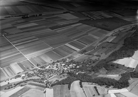
Essert-Pittet is 450 m above sea level. M. , seven kilometers southwest of the district capital Yverdon-les-Bains (beeline). The clustered village extends slightly higher on the eastern edge of the Orbe plain , at the foot of the northern foothills of the Gros de Vaud plateau , in the Vaud Central Plateau .
The area of the 2.8 km² municipal area covers a section of the northern Vaud Central Plateau. The municipality floor extends from the flat Orbe plain ( 435 m above sea level ) eastwards into the wooded slope of the Côtes de Chalamont . Here with 569 m above sea level. M. reached the highest point of Essert-Pittet. To the south is the Crevel promontory ( 490 m above sea level ), and the southern border runs along the Ruisseau des Combes stream . In the west the Canal Oriental (part of the Entreroches Canal ) forms the border in sections . In 1997, 10% of the municipal area was accounted for by settlements, 8% for forests and woodlands and 82% for agriculture.
A few individual farms belong to Essert-Pittet. The neighboring communities of Essert-Pittet are Orbe , Ependes , Suchy and Chavornay .
population
With 164 inhabitants (as of December 31, 2015) Essert-Pittet was one of the smallest municipalities in the canton of Vaud. Of the residents, 86.4% are French-speaking, 4.8% German-speaking and 3.2% English-speaking (as of 2000). The population of Essert-Pittet was 124 inhabitants in 1850 and 123 in 1900. After the population had meanwhile decreased to 95 inhabitants (1980), a slight increase in population has since been registered again.
economy
Essert-Pittet was a predominantly agricultural village until the second half of the 20th century . Even today, arable farming (especially vegetable growing) and fruit growing play an important role in the income structure of the population. There was also some viticulture in the past . Some other jobs are available in local small businesses and in the service sector. In the last few decades Essert-Pittet has also developed into a residential community. Numerous workers are therefore commuters who work mainly in Yverdon .
traffic
The community has good transport connections. It is located on the old main road from Yverdon to Chavornay . The Chavornay motorway junction on the A1 (Lausanne-Yverdon) opened in 1981 , which crosses the municipality, is around 3 km from the town center. The Essert-Pittet junction is also located in the municipality, where the A9 branches off from the A1 to Orbe and Vallorbe . On May 7, 1855, the Yverdon- Bussigny-près-Lausanne section of the Yverdon-Lausanne railway line was opened with a station in Essert-Pittet.
history
The area of Essert-Pittet was crossed by a road from the area Entreroches to Yverdon in Roman times . Coins and bricks have been found from this period. The place was first mentioned in a document in 1100 under the name Exertus , and in 1453 the name Essers appeared . The place name is derived from exsartum , the past participle of the late Latin word exsarire (to clear, to make arable).
Essert-Pittet was initially part of the Belmont reign , but came to the Echallen reign in 1283 . Since 1430 it has formed its own small lordship. With the conquest of Vaud by Bern in 1536, the village came under the administration of the Bailiwick of Yverdon . After the collapse of the Ancien Régime , Essert-Pittet belonged to the canton of Léman from 1798 to 1803 during the Helvetic Republic, which then became part of the canton of Vaud when the mediation constitution came into force . In 1798 it was assigned to the Yverdon district.
Attractions
The Essert-Pittet church was rebuilt in 1746. Some typical farmhouses from the 18th and 19th centuries have been preserved in the village.
Web links
- Official website of the municipality of Essert-Pittet (French)
- Philippe Heubi: Essert-Pittet. In: Historical Lexicon of Switzerland .
- Aerial views of the village
Individual evidence
L'Abbaye | L'Abergement | Agiez | Arnex-sur-Orbe | Ballaigues | Baulmes | Bavois | Belmont-sur-Yverdon | Bioley-Magnoux | Bofflens | Bonvillars | Bretonnières | Bullet | Chamblon | Champagne | Champvent | Chavannes-le-Chêne | Chavornay | Chêne-Pâquier | Le Chenit | Cheseaux-Noréaz | Les Clées | Concise | Corcelles-près-Concise | Cronay | Croy | Cuarny | Démoret | Donneloye | Ependes | Fiez | Fontaines-sur-Grandson | Giez | Grand event | Grandson | Juriens | Le Lieu | Lignette roll | Mathod | Mauborget | Molondine | Montagny-près-Yverdon | Montcherand | Mutrux | Novalles | Onnens | Orbe | Orges | Orzens | Pomy | La Praz | Premier | Provence | Rances | Romainmôtier-Envy | Rovray | Sainte-Croix | Sergey | Suchy | Suscévaz | Tévenon | Treycovagnes | Ursins | Valeyres-sous-Montagny | Valeyres-sous-Rances | Valeyres-sous-Ursins | Vallorbe | Vaulion | Villars-Epeney | Vugelles-La Mothe | Vuiteboeuf | Yverdon-les-Bains | Yvonand
Former municipalities: Arrissoules | Chanéaz | Corcelles-sur-Chavornay | Envy | Essert-Pittet | Essert-sous-Champvent | Fontanezier | Gossens | Gressy | Mézery-près-Donneloye | Prahins | Romainmôtier | Romairon | Vaugondry | Villars-Burquin | Villars-sous-Champvent
Canton of Vaud | Districts of the canton of Vaud | Municipalities of the canton of Vaud