
Pomy VD
| VD is the abbreviation for the canton of Vaud in Switzerland and is used to avoid confusion with other entries of the name Pomy . |
| Pomy | |
|---|---|
 |
|
| State : |
|
| Canton : |
|
| District : | Jura north vaudois |
| BFS no. : | 5926 |
| Postal code : | 1405 |
| Coordinates : | 541 216 / 179017 |
| Height : | 558 m above sea level M. |
| Height range : | 472–641 m above sea level M. |
| Area : | 5.62 km² |
| Residents: | 781 (December 31, 2018) |
| Population density : | 139 inhabitants per km² |
| Website: | www.pomy.ch |
_088.JPG) Pomy |
|
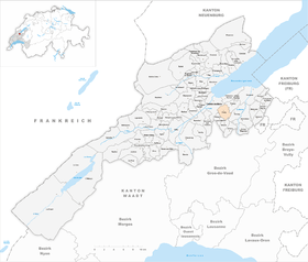
| Location of the municipality | |
  |
|
Pomy is a municipality in the Jura-Nord vaudois district in the canton of Vaud in Switzerland .
geography
Pomy lies at 558 m above sea level. M. , 3 km southeast of the district capital Yverdon-les-Bains (air line). The clustered village extends on a plateau south of the Montéla ridge in the Molasse hill country of the northern Vaud Central Plateau .
The area of the 5.6 km² municipality covers a section of the hill country between the Orbe plain and the Broye . The central part of the area is occupied by a wide plateau that slopes northeast to the valley of Cuarny, to the southwest to that of the Niauque . This brook, a tributary of the Buron , forms the southwestern border. In the south, the municipality extends on the ridge of the Montéla and reaches in the Haut de Baume with 642 m above sea level. M. the highest point of Pomy. In 1997, 7% of the municipal area was accounted for by settlements, 16% for forests and trees and 77% for agriculture.
Pomy includes the hamlet of Chevressy ( 579 m above sea level ) on the southwest slope of Montéla high above Yverdon, the Calamin housing estate ( 500 m above sea level ) on the outskirts of Yverdon and a few individual farms. The neighboring municipalities of Pomy are Yverdon-les-Bains , Cuarny , Cronay , Ursins , Valeyres-sous-Ursins and Gressy .
population
With 781 inhabitants (as of December 31, 2018), Pomy is one of the smaller municipalities in the canton of Vaud. 95.4% of the residents are French-speaking, 1.9% German-speaking and 1.5% Italian-speaking (as of 2000). The population of Pomy was 497 in 1900. After the population had decreased to 400 by 1980, a significant increase in population has since been registered again.
economy
Until the second half of the 20th century, Pomy was a predominantly agricultural village. Even today, arable farming , fruit growing and cattle breeding play an important role in the income structure of the population. Further jobs are available in local small businesses and in the service sector. Pomy has been the location of a vocational training center for the disabled since 1985. In the last few decades Pomy has developed into a residential community. Numerous workers are therefore commuters who work mainly in Yverdon .
traffic
The community has good transport connections. It is located on the main road from Yverdon to Moudon , which has a local bypass near Pomy. The Yverdon-Sud motorway junction on the A1 (Lausanne-Yverdon) opened in 1981 is around 3 km from the town center. Today the municipality is crossed by the 3 km long tunnel de Pomy of the A1 (Yverdon-Payerne) inaugurated in 2001. Pomy is connected to the public transport network by a postbus course that runs from Yverdon to Thierrens .
history
The first written mention of the place took place in 1184 under the name Pomierus . Later the names Pomiers (1211), Pomer (1237) and Pomier (1453) appeared. The place name is derived from the Latin word pomarium (orchard) and refers in particular to apple trees (French pommier ).
Pomy has been part of the Belmont dominion since the Middle Ages . The Montheron Abbey also had basic rights in the area of the village. With the conquest of Vaud by Bern in 1536, Pomy came under the administration of the Bailiwick of Yverdon . After the collapse of the Ancien Régime , the village belonged to the canton of Léman from 1798 to 1803 during the Helvetic Republic, which then became part of the canton of Vaud when the mediation constitution came into force . In 1798 it was assigned to the Yverdon district. As part of a border adjustment, the La Grand-Fin farm was ceded by Pomy to Cuarny in 1964.
Attractions
The Saint-Georges church originally dates from the 14th century, but was later rebuilt several times. Some stately farmhouses from the 17th to 19th centuries have been preserved in the town center.

Parish Church of St. George
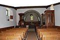
Interior of the parish church

Community hall
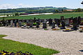
graveyard

tavern
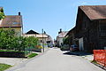
Village center
_109.JPG)
_112.JPG)
_091.JPG)
_106.JPG)
_119.JPG)
_096.JPG)
Web links
- Community information
- Philippe Heubi: Pomy. In: Historical Lexicon of Switzerland .
- Aerial views of the village
Individual evidence
- ↑ Permanent and non-permanent resident population by year, canton, district, municipality, population type and gender (permanent resident population). In: bfs. admin.ch . Federal Statistical Office (FSO), August 31, 2019, accessed on December 22, 2019 .
L'Abbaye | L'Abergement | Agiez | Arnex-sur-Orbe | Ballaigues | Baulmes | Bavois | Belmont-sur-Yverdon | Bioley-Magnoux | Bofflens | Bonvillars | Bretonnières | Bullet | Chamblon | Champagne | Champvent | Chavannes-le-Chêne | Chavornay | Chêne-Pâquier | Le Chenit | Cheseaux-Noréaz | Les Clées | Concise | Corcelles-près-Concise | Cronay | Croy | Cuarny | Démoret | Donneloye | Ependes | Fiez | Fontaines-sur-Grandson | Giez | Grand event | Grandson | Juriens | Le Lieu | Lignette roll | Mathod | Mauborget | Molondine | Montagny-près-Yverdon | Montcherand | Mutrux | Novalles | Onnens | Orbe | Orges | Orzens | Pomy | La Praz | Premier | Provence | Rances | Romainmôtier-Envy | Rovray | Sainte-Croix | Sergey | Suchy | Suscévaz | Tévenon | Treycovagnes | Ursins | Valeyres-sous-Montagny | Valeyres-sous-Rances | Valeyres-sous-Ursins | Vallorbe | Vaulion | Villars-Epeney | Vugelles-La Mothe | Vuiteboeuf | Yverdon-les-Bains | Yvonand
Former municipalities: Arrissoules | Chanéaz | Corcelles-sur-Chavornay | Envy | Essert-Pittet | Essert-sous-Champvent | Fontanezier | Gossens | Gressy | Mézery-près-Donneloye | Prahins | Romainmôtier | Romairon | Vaugondry | Villars-Burquin | Villars-sous-Champvent
Canton of Vaud | Districts of the canton of Vaud | Municipalities of the canton of Vaud