
Mutrux
| Mutrux | |
|---|---|
 |
|
| State : |
|
| Canton : |
|
| District : | Jura north vaudois |
| BFS no. : | 5563 |
| Postal code : | 1428 |
| Coordinates : | 545 754 / 192 716 |
| Height : | 748 m above sea level M. |
| Height range : | 624–1119 m above sea level M. |
| Area : | 3.23 km² |
| Residents: | 158 (December 31, 2018) |
| Population density : | 49 inhabitants per km² |
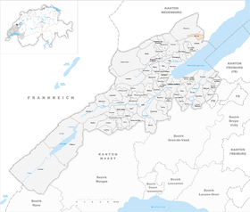
| Location of the municipality | |
  |
|
Mutrux is a municipality in the Jura-Nord vaudois district in the canton of Vaud in Switzerland .
geography
Mutrux is 748 m above sea level. M. , 13 km northeast of the district capital Yverdon-les-Bains (air line). The farming village extends on a cleared island on the eastern slope of Mont Aubert , in a panoramic position around 300 m above the lake level of Lake Neuchâtel .
The area of the 3.2 km² municipal area includes a section on the southern slope of the Jura , which has a relatively low slope in the area of the village. To the west, above Mutrux, joins the Bois des Râpes forest , which occupies the northeast slope of Mont Aubert. On this slope is at 1120 m above sea level. M. the highest point of Mutrux. The northern border of the municipality is largely formed by the valley cut of the La Vaux brook . In 1997, 2% of the municipal area was accounted for by settlements, 62% for forests and woodlands and 36% for agriculture.
Mutrux has a number of individual farms on the slope of Mont Aubert. The neighboring communities of Mutrux are Provence in the west and north and Concise in the canton of Vaud in the south, Vaumarcus in the south-east and La Grande Béroche in the canton of Neuchâtel in the north-east .
population
With 158 inhabitants (as of December 31, 2018) Mutrux is one of the smallest communities in the canton of Vaud. 99.1% of the residents are French-speaking and 0.9% Spanish-speaking (as of 2000). The population of Mutrux was still 182 inhabitants in 1900, after which it halved by 1970 (79 inhabitants). In contrast, the population has increased again, particularly in recent years.
economy
Mutrux still lives mainly from agriculture . In the area of the village arable and fruit growing is practiced, in the higher regions pasture farming. Due to the large proportion of forest in the municipality, forestry also plays a certain role. There are other jobs in local small businesses. Since the place has also developed into a residential community in recent years, many people are employed in the larger communities along Lake Neuchâtel.
traffic
The community is located away from the major thoroughfares. The main access is from Concise , a road connects Mutrux via the neighboring town of Provence with the Neuchâtel municipality of Saint-Aubin-Sauges . The closest connection to the A5 motorway (Yverdon-Neuchâtel) is around 6 km from the town center. The village is connected to the public transport network through the Postbus course that runs from Yverdon to Provence.
history
The first written mention of the place took place in 1358 under the name Mustrueu ; In 1867 the spelling Mutru appeared . The place name goes back to the patois expression mutru ( church ), which is derived from the Latin monasterium ( monastery ). Mutrux had belonged to the Grandson rule since the 14th century . After 1476 Grandson became a bailiwick under the common rule of Bern and Freiburg . After the collapse of the Ancien Régime , the village belonged to the canton of Léman from 1798 to 1803 during the Helvetic Republic, which then became part of the canton of Vaud when the mediation constitution came into force . Mutrux does not have its own church, it belongs to the parish of Provence .
Web links
- Philippe Heubi: Mutrux. In: Historical Lexicon of Switzerland .
- Community information
- Aerial photography
Individual evidence
- ↑ Permanent and non-permanent resident population by year, canton, district, municipality, population type and gender (permanent resident population). In: bfs. admin.ch . Federal Statistical Office (FSO), August 31, 2019, accessed on December 22, 2019 .
L'Abbaye | L'Abergement | Agiez | Arnex-sur-Orbe | Ballaigues | Baulmes | Bavois | Belmont-sur-Yverdon | Bioley-Magnoux | Bofflens | Bonvillars | Bretonnières | Bullet | Chamblon | Champagne | Champvent | Chavannes-le-Chêne | Chavornay | Chêne-Pâquier | Le Chenit | Cheseaux-Noréaz | Les Clées | Concise | Corcelles-près-Concise | Cronay | Croy | Cuarny | Démoret | Donneloye | Ependes | Fiez | Fontaines-sur-Grandson | Giez | Grand event | Grandson | Juriens | Le Lieu | Lignette roll | Mathod | Mauborget | Molondine | Montagny-près-Yverdon | Montcherand | Mutrux | Novalles | Onnens | Orbe | Orges | Orzens | Pomy | La Praz | Premier | Provence | Rances | Romainmôtier-Envy | Rovray | Sainte-Croix | Sergey | Suchy | Suscévaz | Tévenon | Treycovagnes | Ursins | Valeyres-sous-Montagny | Valeyres-sous-Rances | Valeyres-sous-Ursins | Vallorbe | Vaulion | Villars-Epeney | Vugelles-La Mothe | Vuiteboeuf | Yverdon-les-Bains | Yvonand
Former municipalities: Arrissoules | Chanéaz | Corcelles-sur-Chavornay | Envy | Essert-Pittet | Essert-sous-Champvent | Fontanezier | Gossens | Gressy | Mézery-près-Donneloye | Prahins | Romainmôtier | Romairon | Vaugondry | Villars-Burquin | Villars-sous-Champvent
Canton of Vaud | Districts of the canton of Vaud | Municipalities of the canton of Vaud