
Arrissoules
| Arrissoules | ||
|---|---|---|
 |
||
| State : |
|
|
| Canton : |
|
|
| District : | Jura north vaudois | |
| Municipality : | Rovray | |
| Postal code : | 1463 | |
| Coordinates : | 549700 / 183276 | |
| Height : | 641 m above sea level M. | |
| Residents: | 37 (December 31, 2000) | |
_255.JPG) Entrance to Arrissoules |
||
| map | ||
|
||


Arrissoules is a town and formerly an independent political municipality in the district of Yverdon in the canton of Vaud in Switzerland . On January 1, 2005, Arrissoules was incorporated by Rovray .
geography
Arrissoules is 641 m above sea level. M., 11 km east of the district capital Yverdon-les-Bains (beeline). The small farming village extends over a terrace in the Molasse hill country of the northern Vaud Central Plateau . In the north, below the village, begins the valley of Le Pissiau, which descends steeply to Lake Neuchâtel . South of the village, the terrain rises to the forest height of Les Râpes (698 m above sea level). The former municipality area was just 0.85 km².
population
With 37 inhabitants (at the end of 2000), Arrissoules was one of the smallest municipalities in the canton of Vaud before the merger with Rovray. The population of the place was still 76 in 1900. After the population had decreased by more than two thirds to 26 people by 1980, a slight increase in population has been registered since then.
economy
Arrissoules still lives mainly from agriculture , especially from agriculture and cattle breeding . Outside the primary sector there are no jobs in the village.
traffic
The village is located off the main thoroughfares, but is easily accessible from Yvonand and has a bus connection to Yvonand train station at certain times of the day. The Arrissoules area is crossed by the more than 3 km long d'Arrissoules tunnel on the A1 motorway . The Yverdon-Payerne section, and with it the two tubes of the d'Arrissoules tunnel, was opened in 2001.
history
The first written mention of the place took place in 1148 under the name Arresules . In the 12th century, the names Aressoles , Aresoles and Arisoles and 1235 Aresoules appeared . The origin of the place name is unclear. A connection with the word (l) arze ( larch ; Latin larix ) was assumed at the end of the 19th century .
Arrissoules has been under the rule of Saint-Martin-du-Chêne since the Middle Ages . With the conquest of Vaud by Bern in 1536, the village came under the administration of the Bailiwick of Yverdon . Arrissoules still profited well into the 17th century as a station on the road from Yverdon to Payerne , which at that time did not run along Lake Neuchâtel but over the hills. The village only lost its importance with the construction of the new road along the lake shore. After the collapse of the Ancien Régime , Arrissoules belonged to the canton of Léman from 1798 to 1803 during the Helvetic Republic, which then became part of the canton of Vaud when the mediation constitution came into force . In 1798 it was assigned to the Yverdon district. On January 1, 2005, the merger with Rovray was finally completed.
Attractions
photos

Arrissoules village center

school

Residential houses in the village center
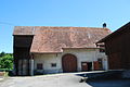
old farmhouse
_265.JPG)
_259.JPG)
_260.JPG)
_262.JPG)
Web links
- Philippe Heubi: Arrissoules. In: Historical Lexicon of Switzerland .
- Aerial view of the village
Individual evidence
- ^ Johann Jakob Egli : Nomina geographica. Language and factual explanation of 42,000 geographical names of all regions of the world. Friedrich Brandstetter, 2nd edition, Leipzig 1893, p. 526
L'Abbaye | L'Abergement | Agiez | Arnex-sur-Orbe | Ballaigues | Baulmes | Bavois | Belmont-sur-Yverdon | Bioley-Magnoux | Bofflens | Bonvillars | Bretonnières | Bullet | Chamblon | Champagne | Champvent | Chavannes-le-Chêne | Chavornay | Chêne-Pâquier | Le Chenit | Cheseaux-Noréaz | Les Clées | Concise | Corcelles-près-Concise | Cronay | Croy | Cuarny | Démoret | Donneloye | Ependes | Fiez | Fontaines-sur-Grandson | Giez | Grand event | Grandson | Juriens | Le Lieu | Lignette roll | Mathod | Mauborget | Molondine | Montagny-près-Yverdon | Montcherand | Mutrux | Novalles | Onnens | Orbe | Orges | Orzens | Pomy | La Praz | Premier | Provence | Rances | Romainmôtier-Envy | Rovray | Sainte-Croix | Sergey | Suchy | Suscévaz | Tévenon | Treycovagnes | Ursins | Valeyres-sous-Montagny | Valeyres-sous-Rances | Valeyres-sous-Ursins | Vallorbe | Vaulion | Villars-Epeney | Vugelles-La Mothe | Vuiteboeuf | Yverdon-les-Bains | Yvonand
Former municipalities: Arrissoules | Chanéaz | Corcelles-sur-Chavornay | Envy | Essert-Pittet | Essert-sous-Champvent | Fontanezier | Gossens | Gressy | Mézery-près-Donneloye | Prahins | Romainmôtier | Romairon | Vaugondry | Villars-Burquin | Villars-sous-Champvent
Canton of Vaud | Districts of the canton of Vaud | Municipalities of the canton of Vaud