
Villars-Epeney
| Villars-Epeney | |
|---|---|
 |
|
| State : |
|
| Canton : |
|
| District : | Jura north vaudois |
| BFS no. : | 5935 |
| Postal code : | 1404 |
| Coordinates : | 543 339 / 181343 |
| Height : | 548 m above sea level M. |
| Height range : | 488-580 m above sea level M. |
| Area : | 0.86 km² |
| Residents: | 100 (December 31, 2018) |
| Population density : | 116 inhabitants per km² |
| Website: | www.villars-epeney.ch |
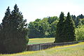
_159.JPG) Entrance to Villars-Epeney (coming from La Mauguettaz) |
|
| Location of the municipality | |
  |
|
Villars-Epeney is a municipality in the Jura-Nord vaudois district in the canton of Vaud in Switzerland .
geography
Villars-Epeney is 548 m above sea level. M. , 5 km east of the district capital Yverdon-les-Bains (beeline). The farming village extends on the slope of the Montéla, which slopes slightly to the northeast, in the Molasse hill country of the northern Vaudois Central Plateau .
The area of the municipality, which is just 0.9 km² in size, comprises a section of the hill country between Lake Neuchâtel and the Broyetal . The community soil is on the northeast slope of the Montéla, in the headwaters of the Ruisseau de l'Epena , which flows in a small hollow in this slope. The highest point of the community is 580 m above sea level. M. reached in the forest of Montéla. In 1997, 2% of the municipal area was accounted for by settlements, 15% for forests and woodlands and 83% for agriculture.
The neighboring communities of Villars-Epeney are Cheseaux-Noréaz in the west and north , Yvonand in the east and Cuarny in the south .
population
With 100 inhabitants (as of December 31, 2018), Villars-Epeney is one of the smallest municipalities in the canton of Vaud. 98.0% of the residents are French-speaking and 2.0% Portuguese-speaking (as of 2000). The population of Villars-Epeney was 51 in 1900. After the population decreased to 27 by 1970, an increase in population has been registered again since then.
economy
Villars-Epeney still lives mainly from agriculture , especially from agriculture and livestock . Outside of the primary sector there are hardly any jobs in the village. Some workers are also commuters who work mainly in Yverdon .
traffic
The community is located off the main thoroughfares on a connecting road from Cheseaux-Noréaz to La Mauguettaz . Villars-Epeney is connected to the public transport network by a postbus course that runs from Yverdon via Cheseaux-Noréaz to Cuarny .
history
The first written mention of the place was in 1177 under the name Espiney , in 1549 the name Villars-Espiney appeared . After the Burgundian Wars , Villars-Epeney came under the administration of the Bailiwick of Grandson in 1476 as a hamlet belonging to Yvonand , which was under the common rule of Bern and Friborg . The hamlet was raised to the status of an independent municipality in 1765. After the collapse of the Ancien Régime , Villars-Epeney belonged to the canton of Léman from 1798 to 1803 during the Helvetic Republic, which then became part of the canton of Vaud when the mediation constitution came into force . In 1798 it was assigned to the Yverdon district.
photos
graveyard

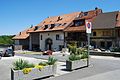
View of the village

Village center
Farmhouse in the village center

View of Lake Neuchâtel
_180.JPG)
_177.JPG)
_172.JPG)
_173.JPG)
_176.JPG)
Web links
- Official website of the municipality of Villars-Epeney
- Community information
- Philippe Heubi: Villars-Epeney. In: Historical Lexicon of Switzerland .
Individual evidence
- ↑ Permanent and non-permanent resident population by year, canton, district, municipality, population type and gender (permanent resident population). In: bfs. admin.ch . Federal Statistical Office (FSO), August 31, 2019, accessed on December 22, 2019 .
L'Abbaye | L'Abergement | Agiez | Arnex-sur-Orbe | Ballaigues | Baulmes | Bavois | Belmont-sur-Yverdon | Bioley-Magnoux | Bofflens | Bonvillars | Bretonnières | Bullet | Chamblon | Champagne | Champvent | Chavannes-le-Chêne | Chavornay | Chêne-Pâquier | Le Chenit | Cheseaux-Noréaz | Les Clées | Concise | Corcelles-près-Concise | Cronay | Croy | Cuarny | Démoret | Donneloye | Ependes | Fiez | Fontaines-sur-Grandson | Giez | Grand event | Grandson | Juriens | Le Lieu | Lignette roll | Mathod | Mauborget | Molondine | Montagny-près-Yverdon | Montcherand | Mutrux | Novalles | Onnens | Orbe | Orges | Orzens | Pomy | La Praz | Premier | Provence | Rances | Romainmôtier-Envy | Rovray | Sainte-Croix | Sergey | Suchy | Suscévaz | Tévenon | Treycovagnes | Ursins | Valeyres-sous-Montagny | Valeyres-sous-Rances | Valeyres-sous-Ursins | Vallorbe | Vaulion | Villars-Epeney | Vugelles-La Mothe | Vuiteboeuf | Yverdon-les-Bains | Yvonand
Former municipalities: Arrissoules | Chanéaz | Corcelles-sur-Chavornay | Envy | Essert-Pittet | Essert-sous-Champvent | Fontanezier | Gossens | Gressy | Mézery-près-Donneloye | Prahins | Romainmôtier | Romairon | Vaugondry | Villars-Burquin | Villars-sous-Champvent
Canton of Vaud | Districts of the canton of Vaud | Municipalities of the canton of Vaud