
Montagny-près-Yverdon
| Montagny-près-Yverdon | |
|---|---|
 |
|
| State : |
|
| Canton : |
|
| District : | Jura north vaudois |
| BFS no. : | 5922 |
| Postal code : | 1442 |
| Coordinates : | 536 903 / 182 612 |
| Height : | 455 m above sea level M. |
| Height range : | 429–504 m above sea level M. |
| Area : | 3.52 km² |
| Residents: | 737 (December 31, 2018) |
| Population density : | 209 inhabitants per km² |
| Website: | www.montagny.ch |
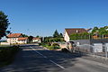
_001.JPG) Enter the town at the roundabout at the motorway entrance |
|
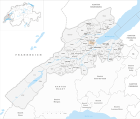
| Location of the municipality | |
  |
|
Montagny-près-Yverdon is a municipality in the district of Jura-Nord vaudois in the canton of Vaud in Switzerland . In the Middle Ages the place was called Montagny-le-Corbe .
geography
Montagny-près-Yverdon is 455 m above sea level. M. , 2.5 km northwest of the district capital Yverdon-les-Bains (air line). The cluster village extends slightly higher on the northern edge of the plain of Yverdon, west of Lake Neuchâtel , in the Vaudois Central Plateau .
The area of the 3.6 km² municipal area covers a section of the northern Vaud Central Plateau. The western part of the area is occupied by the height belonging to the Jura foot plateau between the valley of the Bey in the south and that of the Brine in the north. The highest point of Montagny-près-Yverdon is at 500 m above sea level. M. on the spur above the valley of the Brine, where the ruins of the former castle are still visible. In the south, the municipality extends over the valley of the Bey to the foot of the Mont de Chamblon . To the east the area extends into the plain of Yverdon and in a corner only 100 m wide along the canalised Bey to the shores of Lake Neuchâtel. In 1997, 20% of the municipal area was in settlements, 6% in forests and woodlands, 72% in agriculture and a little less than 2% was unproductive land.
Montagny-près-Yverdon includes the Chamard industrial park ( 437 m above sea level ) and the houses along the road from Yverdon to Grandson as well as some individual farms. The neighboring communities of Montagny-près-Yverdon are in the north-east Grandson , in the north Valeyres-sous-Montagny , in the west Champvent , in the south Chamblon , in the south-south-east Treycovagnes and in the south-east Yverdon-les-Bains .
population
With 737 inhabitants (as of December 31, 2018), Montagny-près-Yverdon is one of the smaller municipalities in the canton of Vaud. 88.5% of the residents are French-speaking, 3.5% German-speaking and 2.8% Italian-speaking (as of 2000). The population of Montagny-près-Yverdon was 263 in 1900. After the population stagnated at 350 from 1950 to 1980, a significant increase in population has since been registered.
economy
Until the second half of the 20th century, Montagny-près-Yverdon was a predominantly agricultural village. Even today, arable farming (especially vegetable crops), fruit growing and, to a lesser extent, viticulture have an important role in the income structure of the population.
Since the 1960s, the creation of an extensive industrial zone on the outskirts of Yverdon has significantly changed the economic structure of the village. The shopping centers of the wholesalers as well as hobby, leisure and sports shops and various specialty shops have settled here. In the last few decades, Montagny-près-Yverdon has also developed into a residential community. Numerous workers are therefore commuters who work mainly in Yverdon .
traffic
The community has excellent transport connections. It is close to the main road from Yverdon to Orbe and to Sainte-Croix . The Yverdon-Ouest motorway junction on the A5 , opened in 1984, is only around 1 km from the town center. Montagny-près-Yverdon is served by the Yverdon city bus network (line 3). The La Brinaz stop on the Yverdon – Ste-Croix narrow-gauge railway , which was inaugurated on November 27, 1893, is also in the municipality .
history
The municipality of Montagny-près-Yverdon was settled very early, which is evidenced by the discovery of objects of Celtic handicrafts. In Roman times the area was crossed by the road from Yverdon to Sainte-Croix, a milestone from around 200 AD was discovered in 1862.
The place was first mentioned in a document in 996 under the name Montaniacum . In 1149 the name Montagniaco and 1174 Montagniei appeared . The place name is derived from the Roman personal name Montan (i) us . Since the 12th century, Montagny was the center of the Montagny-le-Corbe estate, which belonged to the lords of Montfaucon. They built their castle on a ledge over the valley of the Brine. The settlement was also called Montagny-le-Corbe at that time. In the 14th century, rulership passed to the House of Chalon from Burgundy . During the Burgundian Wars , the castle was captured by the Confederates in 1475 and burned down.
After that, the village came under the administration of the Bailiwick of Grandson in 1476 , which was under the common rule of Bern and Friborg . After the collapse of the Ancien Régime , Montagny-près-Yverdon belonged to the canton of Léman from 1798 to 1803 during the Helvetic Republic, which then became part of the canton of Vaud when the mediation constitution came into force . In 1798 it was assigned to the Yverdon district.
Attractions
From the former Montagny-le-Corbe castle, which originally dates back to the 11th century and was not rebuilt after being destroyed in 1475, only a dilapidated tower overgrown with vegetation remains today. The parish church, built in 1769, stands slightly above the village. In the old town center, some farm and wine-growing houses from the 17th to 19th centuries have been preserved.

Village center

Parish church

Parish hall

Bakehouse

Industrial park east of the motorway

Motorway viaduct

Vineyard
View towards the village
_002.JPG)
_028.JPG)
_005.JPG)
_031.JPG)
_005.JPG)
_006.JPG)
_011.JPG)
_015.JPG)
Web links
- Official website of the municipality of Montagny-près-Yverdon
- Philippe Heubi: Montagny-près-Yverdon. In: Historical Lexicon of Switzerland .
- Aerial views of the village
- Montagny-le-Corbe Castle
Individual evidence
- ↑ Permanent and non-permanent resident population by year, canton, district, municipality, population type and gender (permanent resident population). In: bfs. admin.ch . Federal Statistical Office (FSO), August 31, 2019, accessed on December 22, 2019 .
L'Abbaye | L'Abergement | Agiez | Arnex-sur-Orbe | Ballaigues | Baulmes | Bavois | Belmont-sur-Yverdon | Bioley-Magnoux | Bofflens | Bonvillars | Bretonnières | Bullet | Chamblon | Champagne | Champvent | Chavannes-le-Chêne | Chavornay | Chêne-Pâquier | Le Chenit | Cheseaux-Noréaz | Les Clées | Concise | Corcelles-près-Concise | Cronay | Croy | Cuarny | Démoret | Donneloye | Ependes | Fiez | Fontaines-sur-Grandson | Giez | Grand event | Grandson | Juriens | Le Lieu | Lignette roll | Mathod | Mauborget | Molondine | Montagny-près-Yverdon | Montcherand | Mutrux | Novalles | Onnens | Orbe | Orges | Orzens | Pomy | La Praz | Premier | Provence | Rances | Romainmôtier-Envy | Rovray | Sainte-Croix | Sergey | Suchy | Suscévaz | Tévenon | Treycovagnes | Ursins | Valeyres-sous-Montagny | Valeyres-sous-Rances | Valeyres-sous-Ursins | Vallorbe | Vaulion | Villars-Epeney | Vugelles-La Mothe | Vuiteboeuf | Yverdon-les-Bains | Yvonand
Former municipalities: Arrissoules | Chanéaz | Corcelles-sur-Chavornay | Envy | Essert-Pittet | Essert-sous-Champvent | Fontanezier | Gossens | Gressy | Mézery-près-Donneloye | Prahins | Romainmôtier | Romairon | Vaugondry | Villars-Burquin | Villars-sous-Champvent
Canton of Vaud | Districts of the canton of Vaud | Municipalities of the canton of Vaud