
Bonvillars
| Bonvillars | |
|---|---|
 |
|
| State : |
|
| Canton : |
|
| District : | Jura north vaudois |
| BFS no. : | 5551 |
| Postal code : | 1427 |
| Coordinates : | 541 472 / 187846 |
| Height : | 475 m above sea level M. |
| Height range : | 429–1347 m above sea level M. |
| Area : | 7.52 km² |
| Residents: | 505 (December 31, 2018) |
| Population density : | 67 inhabitants per km² |
| Website: | www.bonvillars.ch |
 Bonvillars |
|
| Location of the municipality | |
  |
|
Bonvillars is a municipality in the Jura-Nord vaudois district in the canton of Vaud in Switzerland .
geography
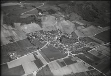
Bonvillars lies at 475 m above sea level. M. , 7 km north-northeast of the district capital Yverdon-les-Bains (air line). The farming village extends at the southern foot of the Jura , at the foot of Mont Aubert , around 1.5 km from the shores of Lake Neuchâtel .
The area of the 7.5 km² municipal area comprises a narrow section on the west bank of Lake Neuchâtel, east of the mouth of the Arnon . The parish extends from the flat lakeshore to the north over the lowland of the Arnon. To the north of the village, the area extends in a narrow strip over the partly wooded, partly meadow slope to the ridge of Mont Aubert. Here is with 1346 m above sea level. M. reached the highest elevation of Bonvillars. A small part of the municipality is located north of the ridge in the catchment area of the La Vaux brook , which flows into Lake Neuchâtel near Vaumarcus . The Chassagne nature reserve is located on the lower southern slope of the Jura . In 1997, 5% of the municipal area was in settlements, 44% in forests and woodlands, 50% in agriculture and a little less than 1% was unproductive land.
Bonvillars has a number of individual farms on the southern slopes of the Jura ( Les Vullierens ) and on the ridge of Mont Aubert. The neighboring communities of Bonvillars are Grandson in the south, Champagne in the southeast , Tévenon in the east , Provence in the north, Concise in the north-northeast, Corcelles-près-Concise in the northeast and Onnen in the east .
population
With 505 inhabitants (as of December 31, 2018) Bonvillars is one of the small communities in the canton of Vaud. 95.9% of the residents are French-speaking, 2.3% German-speaking and 0.9% Italian-speaking (as of 2000). The population of Bonvillars was 470 in 1850 and 515 in 1900. After that, strong emigration was recorded until 1960 (270 inhabitants). In the last few decades a slight upward trend can be observed again.
economy
For a long time, Bonvillars was mainly an agricultural village. Even today, the play viticulture (on a slope above the village), the agriculture (in the lowlands of the Arnon) and the livestock and dairy farming (on the Jurahhöhen) an important role. In 1948, the Caves des viticulteurs de Bonvillars et environs were built to store the wine from the Grandson district. There are other jobs in some craft businesses. The huge warehouses of Fabriques de tabacs réunies SA, built in 1973, stand on the municipal boundary between Bonvillars and Onnens.
traffic
The community has good transport links. It is 1 km from the main road 5 from Neuchâtel to Yverdon . The nearest connection to the highway A5 (Yverdon-Neuchatel), which was passed through the municipality and in 2005 opened to traffic, is located 2.5 km from the village center. On November 7, 1859, the Neuchâtel – Yverdon railway line was inaugurated. The Onnens-Bonvillars Station is largely in the field of Onnens . Bonvillars is also served by the bus route from Gorgier to Yverdon.
history
The 3 m high menhir of Bonvillars is the highest monolith in Switzerland. It stands in a vineyard southwest of Bonvillars. Traces of a Roman estate and remains of graves from the Burgundian period have been found in the municipality of Bonvillars . The place was first mentioned in a document in 1100 under the name Binvilar . In the following years numerous other spellings appeared: Bonus vilar (1124), Binvillare (1148) and Bienvilar (1154). The place name is derived from the Latin words bonus ( good ) and villare ( hamlet ).
Since the Middle Ages Bonvillars belonged to the rule of Grandson , but formed a largely independent administrative unit with its own court among the nobles of Bonvillars (attested since the 12th century). After 1476 Grandson became a bailiwick under the common rule of Bern and Freiburg . After the collapse of the Ancien Régime , Bonvillars belonged to the canton of Léman from 1798 to 1803 during the Helvetic period, which then became part of the canton of Vaud after mediation .
Attractions
The reformed parish church of Saint-Nicolas was mentioned as early as 1148 as a property of the Payerne Abbey. The single-nave church has a side chapel from the 15th century. In 1532, after the Reformation , the parish of Bonvillars came to the parish of Onnens; since 1846 it has belonged to the parish of Champagne. To the west of the village is the former manor La Cour with parts of buildings from the 15th and 17th centuries. It has been owned by the municipality since 1856, has been restored several times and today houses a school and parts of the municipal administration.
In the vineyards on the road to Champagne stands the three-meter menhir from Bonvillars made of gneiss .
Web links
- Official website of the municipality of Bonvillars
- Philippe Heubi: Bonvillars. In: Historical Lexicon of Switzerland .
- Aerial photography
- Menhir from Bonvillars
Individual evidence
- ↑ Permanent and non-permanent resident population by year, canton, district, municipality, population type and gender (permanent resident population). In: bfs. admin.ch . Federal Statistical Office (FSO), August 31, 2019, accessed on December 22, 2019 .
L'Abbaye | L'Abergement | Agiez | Arnex-sur-Orbe | Ballaigues | Baulmes | Bavois | Belmont-sur-Yverdon | Bioley-Magnoux | Bofflens | Bonvillars | Bretonnières | Bullet | Chamblon | Champagne | Champvent | Chavannes-le-Chêne | Chavornay | Chêne-Pâquier | Le Chenit | Cheseaux-Noréaz | Les Clées | Concise | Corcelles-près-Concise | Cronay | Croy | Cuarny | Démoret | Donneloye | Ependes | Fiez | Fontaines-sur-Grandson | Giez | Grand event | Grandson | Juriens | Le Lieu | Lignette roll | Mathod | Mauborget | Molondine | Montagny-près-Yverdon | Montcherand | Mutrux | Novalles | Onnens | Orbe | Orges | Orzens | Pomy | La Praz | Premier | Provence | Rances | Romainmôtier-Envy | Rovray | Sainte-Croix | Sergey | Suchy | Suscévaz | Tévenon | Treycovagnes | Ursins | Valeyres-sous-Montagny | Valeyres-sous-Rances | Valeyres-sous-Ursins | Vallorbe | Vaulion | Villars-Epeney | Vugelles-La Mothe | Vuiteboeuf | Yverdon-les-Bains | Yvonand
Former municipalities: Arrissoules | Chanéaz | Corcelles-sur-Chavornay | Envy | Essert-Pittet | Essert-sous-Champvent | Fontanezier | Gossens | Gressy | Mézery-près-Donneloye | Prahins | Romainmôtier | Romairon | Vaugondry | Villars-Burquin | Villars-sous-Champvent
Canton of Vaud | Districts of the canton of Vaud | Municipalities of the canton of Vaud