
Montcherand
| Montcherand | |
|---|---|
 |
|
| State : |
|
| Canton : |
|
| District : | Jura north vaudois |
| BFS no. : | 5756 |
| Postal code : | 1354 |
| Coordinates : | 529063 / 176 122 |
| Height : | 556 m above sea level M. |
| Height range : | 450–615 m above sea level M. |
| Area : | 3.07 km² |
| Residents: | 488 (December 31, 2018) |
| Population density : | 159 inhabitants per km² |
| Website: | www.montcherand.ch |
_282.JPG) Entrance to Montcherand |
|
| Location of the municipality | |
  |
|
Montcherand is a municipality in the Jura-Nord vaudois district of the canton of Vaud in Switzerland .
geography
Montcherand lies at 556 m above sea level. M. , 2 km northwest of Orbe and 11 km west-southwest of the district capital Yverdon-les-Bains (beeline). The farming village extends in the Waadtländer Mittelland , on a slope inclined to the east on the Jura foot plateau , north of the Orbe valley cut .
The area of the 3.1 km² municipal area includes a section of the Jura foot plateau. The southern border runs along the course of the Orbe, which has carved a gorge-like valley into the plateau, the protected Gorges de l'Orbe . The municipality floor extends northward over the slightly undulating plateau with the forest hill Châtillon ( 555 m above sea level ). The highest point of Montcherand is 615 m above sea level. M. reached in the Plume forest above the Orbe Gorge. In 1997, 16% of the municipal area was in settlements, 30% in forests and woodlands, 53% in agriculture and a little less than 1% was unproductive land.
The hamlet of Creux au Loup ( 572 m above sea level ) on the northern edge of the village and a few individual farms belong to Montcherand . The neighboring municipalities of Montcherand are Orbe , Agiez , Les Clées , Sergey and Valeyres-sous-Rances .
population
With 488 inhabitants (as of December 31, 2018), Montcherand is one of the small communities in the canton of Vaud. 95.3% of the residents are French-speaking, 1.2% Portuguese-speaking and 1.0% Italian-speaking (as of 2000). The population of Montcherand was 258 in 1900 and 245 in 1970. Since then a significant increase in population has been recorded.
economy
Up until the 20th century, Montcherand was a predominantly agricultural village. On the fertile soils at the foot of the Jura, mainly arable farming is practiced. The Compagnie vaudoise des forces motrices du Lac de Joux et de l'Orbe has been operating on the edge of the Orbe valley since 1908. There are other jobs in local small businesses. In the last few decades, Montcherand has developed into a residential community. Many workers are therefore commuters who work in Orbe or Yverdon .
traffic
The community has good transport connections. It is on the main road from Orbe to Vallorbe or over the Jougnepass to Pontarlier in France . The town center has been relieved of transit traffic since the opening of the A9 motorway . The Postbus course, which runs from Orbe to Vallorbe, connects Montcherand to the public transport network.
history
In the Middle Ages, Montcherand belonged to the lordship of Les Clées . The Baulmes priory and, from the 12th century, Payerne Abbey had rich estates in Montcherand. With the conquest of Vaud by Bern in 1536, the place became part of the Kastlanei Les Clées under the Landvogtei Yverdon. After the collapse of the Ancien Régime , Montcherand belonged to the canton of Léman from 1798 to 1803 during the Helvetic Republic, which then became part of the canton of Vaud when the mediation constitution came into force . It was assigned to the Orbe district in 1798.
Attractions
The Saint-Etienne church in Montcherand dates from the 11th and 12th centuries. It was a stage on the Way of St. James . The single-nave building has a semicircular apse , in which important Romanesque wall paintings were discovered in 1902 , which were whitewashed during the Reformation . The castle of Montcherand, flanked by two square towers, was built in 1790 based on the castle Chamblon . Today it houses a children's home. Some characteristic farmhouses from the 17th to 19th centuries have been preserved in the town center.
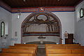
Apse of the Saint Stephen church

View of the church

Village center

House in the village center

Village fountain

Village center
_302.JPG)
_300.JPG)
_287.JPG)
_288.JPG)
_290.JPG)
_309.JPG)
Personalities
- Léon Nicole (1887–1965), Stalinist politician
Web links
- Official website of the municipality of Montcherand (French)
- Anne Rochat-Morel: Montcherand. In: Historical Lexicon of Switzerland .
- Aerial photography
Individual evidence
- ↑ Permanent and non-permanent resident population by year, canton, district, municipality, population type and gender (permanent resident population). In: bfs. admin.ch . Federal Statistical Office (FSO), August 31, 2019, accessed on December 22, 2019 .
L'Abbaye | L'Abergement | Agiez | Arnex-sur-Orbe | Ballaigues | Baulmes | Bavois | Belmont-sur-Yverdon | Bioley-Magnoux | Bofflens | Bonvillars | Bretonnières | Bullet | Chamblon | Champagne | Champvent | Chavannes-le-Chêne | Chavornay | Chêne-Pâquier | Le Chenit | Cheseaux-Noréaz | Les Clées | Concise | Corcelles-près-Concise | Cronay | Croy | Cuarny | Démoret | Donneloye | Ependes | Fiez | Fontaines-sur-Grandson | Giez | Grand event | Grandson | Juriens | Le Lieu | Lignette roll | Mathod | Mauborget | Molondine | Montagny-près-Yverdon | Montcherand | Mutrux | Novalles | Onnens | Orbe | Orges | Orzens | Pomy | La Praz | Premier | Provence | Rances | Romainmôtier-Envy | Rovray | Sainte-Croix | Sergey | Suchy | Suscévaz | Tévenon | Treycovagnes | Ursins | Valeyres-sous-Montagny | Valeyres-sous-Rances | Valeyres-sous-Ursins | Vallorbe | Vaulion | Villars-Epeney | Vugelles-La Mothe | Vuiteboeuf | Yverdon-les-Bains | Yvonand
Former municipalities: Arrissoules | Chanéaz | Corcelles-sur-Chavornay | Envy | Essert-Pittet | Essert-sous-Champvent | Fontanezier | Gossens | Gressy | Mézery-près-Donneloye | Prahins | Romainmôtier | Romairon | Vaugondry | Villars-Burquin | Villars-sous-Champvent
Canton of Vaud | Districts of the canton of Vaud | Municipalities of the canton of Vaud