
Rovray
| Rovray | |
|---|---|
 |
|
| State : |
|
| Canton : |
|
| District : | Jura north vaudois |
| BFS no. : | 5928 |
| Postal code : | 1463 |
| Coordinates : | 548 412 / 181 761 |
| Height : | 650 m above sea level M. |
| Height range : | 486–691 m above sea level M. |
| Area : | 3.20 km² |
| Residents: | 179 (December 31, 2018) |
| Population density : | 56 inhabitants per km² |
| Website: | www.rovray.ch |
 Rovray |
|
| Location of the municipality | |
  |
|
Rovray is a municipality in the Jura-Nord vaudois district in the canton of Vaud in Switzerland . On January 1, 2005, Rovray merged with Arrissoules ; however, the new parish still bears the name Rovray.
geography
Rovray lies at 650 m above sea level. M. , 10 km east of the district capital Yverdon-les-Bains (beeline). The street line village extends on a plateau in the Molasse hill country of the northern Vaud Central Plateau , east of the valley of the Mentue .
The area of the 3.2 km² large municipality covers a section of the hill country between Lake Neuchâtel and the Broyetal . The southwestern part is occupied by the Rovray plateau, which is bordered in the southwest by the deeply cut valley of the Ruisseau des Vaux and in the northwest by the steep drop towards Lake Neuchâtel. To the northeast, the municipality extends over the heights of La Baume ( 675 m above sea level ) and Les Râpes (at 690 m above sea level, the highest point in Rovray) to the terrace of Arrissoules. In 1997, 3% of the municipal area was in settlements, 20% in forests and woodlands, 76% in agriculture and a little less than 1% was unproductive land.
The formerly independent village of Arrissoules and some individual farms belong to Rovray . The neighboring communities of Rovray are Yvonand , Molondin and Chavannes-le-Chêne in the canton of Vaud and Cheyres-Châbles in the canton of Friborg .
population
With 179 inhabitants (as of December 31, 2018), Rovray is one of the smallest municipalities in the canton of Vaud. 98.8% of the residents are French-speaking and 1.2% English-speaking (as of 2000). The population of Rovray (including Arrissoules) was 243 in 1900. After the population had decreased by more than 50% to 110 people by 1980, a slight increase in population has been registered since then.
economy
Rovray still lives mainly from agriculture , especially from agriculture and cattle breeding . Outside of the primary sector there are hardly any jobs in the village. Some workers are also commuters who work mainly in Yverdon .
traffic
The village of Rovray is located off the main thoroughfares on a connecting road from Yvonand to Chavannes-le-Chêne , while Arrissoules can be reached via relatively narrow streets from Rovray or Cheyres . Rovray and Arrissoules are also connected to the public transport network at certain times of the day by a post bus course that opens up the hinterland from Yvonand train station.
history
The place name is derived from the Latin word roboretum (oak grove). Rovray was under the rule of Saint-Martin-du-Chêne in the Middle Ages . With the conquest of Vaud by Bern in 1536, the village came under the administration of the Bailiwick of Yverdon . After the collapse of the Ancien Régime , Rovray belonged to the canton of Léman from 1798 to 1803 during the Helvetic Republic, which then became part of the canton of Vaud when the mediation constitution came into force . In 1798 it was assigned to the Yverdon district. On January 1, 2005, Rovray merged with the neighboring municipality of Arrissoules , but kept its name.
Attractions
The chapel of Rovray, the first construction of which dates from 1448, has always been dependent on the parish of Yvonand. The current church was rebuilt in 1754.
All of Rovray's 18th and 19th century farmhouses have a uniform gable orientation from southwest to northeast. The village also has a bakery .

church

Entrance

Village center
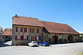
Typical farmhouse

View towards the church

Entrance to Arrissoules
_240.JPG)
_228.JPG)
_231.JPG)
_235.JPG)
_252.JPG)
_253.JPG)
Personalities
Alice Rivaz (1901–1998), writer, was born in Rovray.
Web links
- Community information
- Philippe Heubi: Arrissoules. In: Historical Lexicon of Switzerland .
- Philippe Heubi: Rovray. In: Historical Lexicon of Switzerland .
- Aerial views of the village
Individual evidence
- ↑ Permanent and non-permanent resident population by year, canton, district, municipality, population type and gender (permanent resident population). In: bfs. admin.ch . Federal Statistical Office (FSO), August 31, 2019, accessed on December 22, 2019 .
L'Abbaye | L'Abergement | Agiez | Arnex-sur-Orbe | Ballaigues | Baulmes | Bavois | Belmont-sur-Yverdon | Bioley-Magnoux | Bofflens | Bonvillars | Bretonnières | Bullet | Chamblon | Champagne | Champvent | Chavannes-le-Chêne | Chavornay | Chêne-Pâquier | Le Chenit | Cheseaux-Noréaz | Les Clées | Concise | Corcelles-près-Concise | Cronay | Croy | Cuarny | Démoret | Donneloye | Ependes | Fiez | Fontaines-sur-Grandson | Giez | Grand event | Grandson | Juriens | Le Lieu | Lignette roll | Mathod | Mauborget | Molondine | Montagny-près-Yverdon | Montcherand | Mutrux | Novalles | Onnens | Orbe | Orges | Orzens | Pomy | La Praz | Premier | Provence | Rances | Romainmôtier-Envy | Rovray | Sainte-Croix | Sergey | Suchy | Suscévaz | Tévenon | Treycovagnes | Ursins | Valeyres-sous-Montagny | Valeyres-sous-Rances | Valeyres-sous-Ursins | Vallorbe | Vaulion | Villars-Epeney | Vugelles-La Mothe | Vuiteboeuf | Yverdon-les-Bains | Yvonand
Former municipalities: Arrissoules | Chanéaz | Corcelles-sur-Chavornay | Envy | Essert-Pittet | Essert-sous-Champvent | Fontanezier | Gossens | Gressy | Mézery-près-Donneloye | Prahins | Romainmôtier | Romairon | Vaugondry | Villars-Burquin | Villars-sous-Champvent
Canton of Vaud | Districts of the canton of Vaud | Municipalities of the canton of Vaud