
Ligner roll
| Ligner roll | |
|---|---|
 |
|
| State : |
|
| Canton : |
|
| District : | Jura north vaudois |
| BFS no. : | 5755 |
| Postal code : | 1357 |
| Coordinates : | 524 912 / 177006 |
| Height : | 760 m above sea level M. |
| Height range : | 587–1416 m above sea level M. |
| Area : | 10.64 km² |
| Residents: | 419 (December 31, 2018) |
| Population density : | 39 inhabitants per km² |
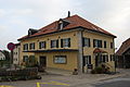
 Village center with a view of the church |
|
| Location of the municipality | |
  |
|
Lignerolle is a municipality in the Jura-Nord vaudois district in the canton of Vaud in Switzerland .
geography
Lignerolle is 760 m above sea level. M. , 6 km west-northwest of Orbe and 14 km west-southwest of the district capital Yverdon-les-Bains (linear distance). The farming village extends on the southern slope of the Suchet in a hollow, north of the Orbe valley .
The area of the 10.6 km² municipal area includes a section of the Vaudois Jura . The municipality extends from the foot of the Jura to the northwest over the densely forested steep slope divided by two valleys ( Les Fourmillières and Montoulevet ) to the anticline of the Suchet. At the height of Bel Coster is at 1415 m above sea level. M. reached the highest point of Lignerolle. Here there are extensive Jura high pastures with the typical mighty spruce trees , which either stand individually or in groups. In the southwest the area extends to the course of the Orbe, which flows here in a deeply cut valley. In 1997, 4% of the municipal area was accounted for by settlements, 47% for forests and trees and 49% for agriculture.
Lignerolle includes the La Bessonne farm estate ( 1090 m above sea level ) on the southern slope of the Suchet anticline as well as some individual farms. Neighboring municipalities of Lignerolle are Ballaigues , Les Clées and L'Abergement in the canton of Vaud and Jougne in neighboring France .
population
With 419 inhabitants (as of December 31, 2018), Lignerolle is one of the small communities in the canton of Vaud. 94.6% of the residents are French-speaking, 3.0% German-speaking and 0.9% Italian-speaking (as of 2000). The population of Lignerolle was 308 in 1900. After that it commuted around 300 inhabitants, decreased to 262 inhabitants by 1980, since then a significant population increase has been observed again.
economy
Until the middle of the 20th century, Lignerolle was mainly an agricultural village. On the fertile soils at the foot of the Jura, mainly arable farming is practiced, there are some fruit trees near the village , while cattle and dairy farming predominate on the Jura heights . There are other jobs in wood processing and in local small businesses. In the last few decades Lignerolle has developed into a residential community. Many workers are therefore commuters who work in Orbe or Yverdon .
traffic
The community has good transport connections. It is on the main road from Orbe to Vallorbe or over the Jougnepass to Pontarlier in France. Since 1989, when the A9 motorway was opened, the center of Lignerolle has been relieved of transit traffic. The A9 runs below the village with several Lehnen viaducts along the northern slope of the Orbe valley. Lignerolle is connected to the public transport network through the Postbus course, which runs from Orbe to Vallorbe.
history
The place was first mentioned in a document in 1165 under the name Lineroles . Later, the names Lineroules (1228) and Lignerolles (1867) appeared. The place name is derived from the Latin word linum ( flax ). Lignerolle has belonged to the lordship of Les Clées since the Middle Ages . It separated from this in 1302 and together with the neighboring town of Ballaigues formed its own small rule. The place had a certain prosperity thanks to its location on the trade route over the Jougnepass. With the conquest of Vaud by Bern in 1536, Lignerolle became part of the Landvogtei Yverdon. After the collapse of the Ancien Régime , the village belonged to the canton of Léman from 1798 to 1803 during the Helvetic Republic, which then became part of the canton of Vaud when the mediation constitution came into force . Lignerolle was assigned to the Orbe district in 1798.
The Lignerolle barrier was built from July 1938. It formed the second line of defense on the attack axis that crosses the Strait of Jougne. The fortification plan comprises 15 bunkers as well as around 20 tank barriers and tank obstacles.
Attractions
The parish church of Saint-Vit is mentioned as early as 1228 and probably goes back to a church from the 9th century. The church fell victim to a fire in the 15th century. It was then rebuilt, while the choir was integrated into the new building from 1400. The so-called Schloss von Lignerolle, actually a fortified house, was built in the 17th century.
photos

The so-called Lignerolle Castle
Parish hall

Parish Church of Saint Vit


Web links
- Community information
- Guy Le Comte: Lignerolle. In: Historical Lexicon of Switzerland .
- Aerial photography
Individual evidence
- ↑ Permanent and non-permanent resident population by year, canton, district, municipality, population type and gender (permanent resident population). In: bfs. admin.ch . Federal Statistical Office (FSO), August 31, 2019, accessed on December 22, 2019 .
- ↑ Silvio Keller, Maurice Lovisa: Military monuments in the cantons of Vaud and Geneva, VBS 2006 In: Federal Department of Defense , Civil Protection and Sport (ed.): Military monuments in the cantons of Vaud and Geneva. Inventory of the combat and command structures. (pdf, 5.5 MB)
- ^ MOB Romande, Association Suisse Romande de Reconstitution Historique 1898-1945: "Mémoires de Béton" Lignerolle (VD), 1er / 2 Aout 2014
- ^ MOB Romande: Three works have been acquired by the Fondation du Fort de Vallorbe (Pré-Giroud) [1]
L'Abbaye | L'Abergement | Agiez | Arnex-sur-Orbe | Ballaigues | Baulmes | Bavois | Belmont-sur-Yverdon | Bioley-Magnoux | Bofflens | Bonvillars | Bretonnières | Bullet | Chamblon | Champagne | Champvent | Chavannes-le-Chêne | Chavornay | Chêne-Pâquier | Le Chenit | Cheseaux-Noréaz | Les Clées | Concise | Corcelles-près-Concise | Cronay | Croy | Cuarny | Démoret | Donneloye | Ependes | Fiez | Fontaines-sur-Grandson | Giez | Grand event | Grandson | Juriens | Le Lieu | Lignette roll | Mathod | Mauborget | Molondine | Montagny-près-Yverdon | Montcherand | Mutrux | Novalles | Onnens | Orbe | Orges | Orzens | Pomy | La Praz | Premier | Provence | Rances | Romainmôtier-Envy | Rovray | Sainte-Croix | Sergey | Suchy | Suscévaz | Tévenon | Treycovagnes | Ursins | Valeyres-sous-Montagny | Valeyres-sous-Rances | Valeyres-sous-Ursins | Vallorbe | Vaulion | Villars-Epeney | Vugelles-La Mothe | Vuiteboeuf | Yverdon-les-Bains | Yvonand
Former municipalities: Arrissoules | Chanéaz | Corcelles-sur-Chavornay | Envy | Essert-Pittet | Essert-sous-Champvent | Fontanezier | Gossens | Gressy | Mézery-près-Donneloye | Prahins | Romainmôtier | Romairon | Vaugondry | Villars-Burquin | Villars-sous-Champvent
Canton of Vaud | Districts of the canton of Vaud | Municipalities of the canton of Vaud