
Yvonand
| Yvonand | |
|---|---|
 |
|
| State : |
|
| Canton : |
|
| District : | Jura north vaudois |
| BFS no. : | 5939 |
| Postal code : | 1462 |
| UN / LOCODE : | CH YVD |
| Coordinates : | 547 047 / 183 224 |
| Height : | 438 m above sea level M. |
| Height range : | 429–675 m above sea level M. |
| Area : | 13.40 km² |
| Residents: | 3427 (December 31, 2018) |
| Population density : | 256 inhabitants per km² |
| Website: | www.yvonand.ch |
 Yvonand |
|
| Location of the municipality | |
  |
|
Yvonand is a municipality in the Jura-Nord vaudois district in the canton of Vaud in Switzerland .
geography
Yvonand lies at 438 m above sea level. M. , 8 km east-northeast of the district capital Yverdon-les-Bains (linear distance). The village extends on the alluvial plain of the Mentue , shortly before its confluence with Lake Neuchâtel , in the northern Vaudois Plateau .
The area of the 13.4 km² municipality covers a section of the hill country between Lake Neuchâtel and the Broyetal . The central part of the area is occupied by the wide alluvial plain of the Mentue, which flows into Lake Neuchâtel with a small delta. The lake shore in the Yvonand region is flat and surrounded by a belt of reeds and forests. In the south-east, the communal soil extends to the edge of the adjacent high plateau at Rovray and Arrissoules and reaches the highest point at 675 m above sea level at La Baume , which slopes down towards Yvonand with a rocky edge . M. The southern part of the village includes up to 1 km wide Talniederung the Mentue below her in the molasse recessed Kerbtals. The side stream Ruisseau des Vaux , which flows from the right, has also created a notched valley over the course of millions of years due to its erosive power . Between these two valleys is the Bois de Montessy forest and the adjacent plateau of Niédens. The western boundary runs in parts along the Ruisseau de l'Epena stream , which rises on the ridge of the Montéla . In 1997, 10% of the municipal area was in settlements, 33% in forests and woodlands, 54% in agriculture and a little less than 3% was unproductive land.
The hamlets of Mordagne ( 436 m above sea level ) in the alluvial plain of the Mentue west of the river, Le Moulin ( 451 m above sea level ) at the entrance to the Vallon des Vaux, Les Vursys ( 442 m above sea level ) belong to Yvonand . ) and La Mauguettaz ( 452 m above sea level ) in the valley of the Mentue, Grande-Moille ( 522 m above sea level ) on the northeast slope of Montéla, Niédens-Dessous ( 549 m above sea level ) and Niédens-Dessus ( 565 m above sea level ) on the plateau between the valleys of Mentue and Ruisseau des Vaux as well as numerous individual farms. Neighboring municipalities of Yvonand are Cheseaux-Noréaz , Villars-Epeney , Cuarny , Cronay , Donneloye , Molondin and Rovray in the canton of Vaud and Cheyres-Châbles in the canton of Friborg .
population
With 3427 inhabitants (as of December 31, 2018), Yvonand is one of the medium-sized municipalities in the canton of Vaud and is also the second largest municipality in the Yverdon district. 91.9% of the residents are French-speaking, 4.4% German-speaking and 1.1% Portuguese-speaking (as of 2000). The population of Yvonand was 861 in 1850 and 1187 in 1900. Thereafter, the number of inhabitants rose only slightly until 1980 (1328 inhabitants). Since then, the population has grown rapidly.
economy
Yvonand was a predominantly agricultural village until the end of the 19th century . There was also some small industry, such as mills, brickworks and sawmills. With the improved transport connections after the opening of the railway line and the construction of the lakeside road, larger companies also settled in Yvonand. These included the Dutoit-Morandi brickworks, which was in operation from 1880 to 1979, and the metal construction company Geilinger (1975-1997).
Today arable farming , fruit growing and cattle breeding are only of secondary importance in the income structure of the population. Fish farming is also carried out. In addition to local small businesses, a cable factory, the food industry, mechanical workshops and information technology companies play an important role.
Yvonand also has an agricultural center, several leisure facilities (sports fields, sports boat harbor and campsites). Thanks to the boat harbor and the beautiful beach on the south shore of Lake Neuchâtel in the Grande Cariçaie, there is also some tourism. In the past few decades, Yvonand has developed into a residential community. Some workers are therefore commuters who work mainly in the Yverdon area .
traffic
The community is very well developed in terms of traffic. It is located on the main road from Yverdon to Estavayer-le-Lac . Since 2001, through traffic has been routed via the newly opened Yverdon-Payerne section of the A1 motorway (Lausanne-Bern). This motorway runs on the heights south of Yvonand, which is why the deep valleys of the Mentue and the Ruisseau des Vaux had to be spanned by two imposing viaducts, each over 100 m high ( Pont sur la Mentue and Viaduc des Vaux). The nearest motorway connections are Yverdon-Ouest (10 km away) and Estavayer-le-Lac (14 km away).
On February 1, 1877, the Yverdon – Payerne railway line was put into operation with a station in Yvonand. A bus line takes care of the fine distribution in public transport, serving the municipalities of the hinterland on a circular route.
history

Yvonand can look back on a very long tradition of settlement. The caves in the Vallon des Vaux were used as the first settlement sites around 4000 BC. Some rock carvings from this period have survived. In the Bronze Age , pile dwelling settlements were established in the Bay of Yvonand. The municipality was also inhabited in the Celtic and Roman times, as it was on the road from Eburodunum (Yverdon) to Aventicum ( Avenches ). At Mordagne, west of the Mentue, the foundations of a Roman villa were excavated, which was built around 100 AD. The settlement area, which also included a sanctuary (a Gallo-Roman temple ), was probably inhabited until around the year 400.
The place was first mentioned in a document in 1009 under the name Evonant . Later, the names Ivonant (1100), de Vonant in the 12th century, Eyvonant (1437) and Yvonant (1453) appeared. The place name is probably made up of the Germanic personal name Evo and the Celtic word nant , which denoted a stream or a valley.
Ever since Yvonand was first mentioned, there was a church in the village that belonged to the Bishop of Lausanne . The village had been part of the Grandson rule since the Middle Ages . After the Burgundian Wars , Yvonand came under the administration of the Bailiwick of Grandson in 1476, which was under the common rule of Bern and Friborg. It formed an exclave on the southern shore of the lake and had its own court of law. In 1531 the Reformation was introduced in the place . After the collapse of the Ancien Régime , Yvonand belonged to the canton of Léman from 1798 to 1803 during the Helvetic Republic, which then became part of the canton of Vaud when the mediation constitution came into force . In 1798 it was assigned to the Yverdon district.
Attractions
The reformed parish church was rebuilt in 1749 and received a new tower in 1906. The Catholic chapel dates from 1959. Another chapel is located in the hamlet of Niédens-Dessous.
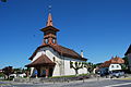
Reformed parish church

Interior of the church
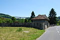
Cemetery, in the background the Pont de Menthue motorway viaduct

graveyard

Cemetery entrance

Village center

Entrance to the village of Les Vursys

La Mauguettaz

Niédens-Dessus
_209.JPG)
_217.JPG)
_197.JPG)
_199.JPG)
_205.JPG)
_220.JPG)
_181.JPG)
_150.JPG)

Web links
- Official website of the municipality of Yvonand
- Community information
- Régine Pasche-Cuagnier: Yvonand. In: Historical Lexicon of Switzerland .
- Geography and History of Yvonand
- Aerial views of the village
Individual evidence
- ↑ Permanent and non-permanent resident population by year, canton, district, municipality, population type and gender (permanent resident population). In: bfs. admin.ch . Federal Statistical Office (FSO), August 31, 2019, accessed on December 22, 2019 .
L'Abbaye | L'Abergement | Agiez | Arnex-sur-Orbe | Ballaigues | Baulmes | Bavois | Belmont-sur-Yverdon | Bioley-Magnoux | Bofflens | Bonvillars | Bretonnières | Bullet | Chamblon | Champagne | Champvent | Chavannes-le-Chêne | Chavornay | Chêne-Pâquier | Le Chenit | Cheseaux-Noréaz | Les Clées | Concise | Corcelles-près-Concise | Cronay | Croy | Cuarny | Démoret | Donneloye | Ependes | Fiez | Fontaines-sur-Grandson | Giez | Grand event | Grandson | Juriens | Le Lieu | Lignette roll | Mathod | Mauborget | Molondine | Montagny-près-Yverdon | Montcherand | Mutrux | Novalles | Onnens | Orbe | Orges | Orzens | Pomy | La Praz | Premier | Provence | Rances | Romainmôtier-Envy | Rovray | Sainte-Croix | Sergey | Suchy | Suscévaz | Tévenon | Treycovagnes | Ursins | Valeyres-sous-Montagny | Valeyres-sous-Rances | Valeyres-sous-Ursins | Vallorbe | Vaulion | Villars-Epeney | Vugelles-La Mothe | Vuiteboeuf | Yverdon-les-Bains | Yvonand
Former municipalities: Arrissoules | Chanéaz | Corcelles-sur-Chavornay | Envy | Essert-Pittet | Essert-sous-Champvent | Fontanezier | Gossens | Gressy | Mézery-près-Donneloye | Prahins | Romainmôtier | Romairon | Vaugondry | Villars-Burquin | Villars-sous-Champvent
Canton of Vaud | Districts of the canton of Vaud | Municipalities of the canton of Vaud