
Ursins
| Ursins | |
|---|---|
 |
|
| State : |
|
| Canton : |
|
| District : | Jura north vaudois |
| BFS no. : | 5932 |
| Postal code : | 1412 |
| Coordinates : | 541 125 / 176 238 |
| Height : | 645 m above sea level M. |
| Height range : | 565–689 m above sea level M. |
| Area : | 3.36 km² |
| Residents: | 230 (December 31, 2018) |
| Population density : | 68 inhabitants per km² |
| Website: | www.ursins.ch |
 Ursins Church |
|
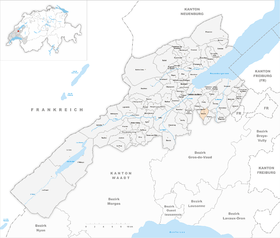
| Location of the municipality | |
  |
|
Ursins is a municipality in the Jura-Nord vaudois district in the canton of Vaud in Switzerland .
geography
Ursins lies at 645 m above sea level. M. , 5 km south-southeast of the district capital Yverdon-les-Bains (air line). The clustered village extends on the northern roof of the wide ridge between the Orbe plain and the Mentue valley , in the Vaudois Central Plateau .
The area of the 3.4 km² large municipal area covers a section of the hill country between the Orbe plain and the Broyetal . The area is occupied by the open slope of the Ursins, which slopes gently towards the north. In the west is the headwaters of the Niauque (tributary of the Buron ), in the east that of the Ruisseau du Lin , which flows to the Mentue. To the south, the municipality extends to the edge of the vast forest area Grand Bois d'Essertines . Here is at 688 m above sea level. M. in the Bois de la Tailla reached the highest point of Ursins. In 1997, 4% of the municipal area was accounted for by settlements, 20% for forests and trees and 76% for agriculture.
A few individual farms belong to Ursins. The neighboring municipalities of Ursins are Pomy in the north, Cronay in the north- east, Orzens in the south - east , Essertines-sur-Yverdon in the south - west and Valeyres-sous-Ursins in the north-west .
population
With 230 inhabitants (as of December 31, 2018) Ursins is one of the small communities in the canton of Vaud. 96.5% of the residents are French-speaking and 1.2% German-speaking (as of 2000). The population of Ursins was 201 in 1900. After the population had decreased to 127 by 1970, a slight increase has been registered since then.
economy
Ursins still lives mainly from agriculture , especially from agriculture and cattle breeding . Outside of the primary sector there are hardly any jobs in the village. Many workers are also commuters who work mainly in Yverdon .
traffic
The community is very well developed in terms of traffic, although it is located away from the major thoroughfares. The Yverdon-Sud motorway junction on the A1 (Lausanne-Yverdon) opened in 1981 is around 6 km from the town center. Ursins is connected to the public transport network by a postbus course that runs from Yverdon to Bercher .
history
The municipality of Ursins was already settled in Roman times. The place was probably used as a sanctuary, which could be reconstructed based on the excavations carried out. Remains of a temple from the 1st century AD and a small amphitheater have been found.
The place was first mentioned in a document in 1009 under the name de Ursingis . Later the names Ursi (1174) appeared, today's name Ursins (1228), then Ursens (1282), Ursin (1376) and Orsens (1453). Just like the name of the neighboring municipality of Orzens , the place name is probably derived from the Burgundian personal name Urs (from Latin ursus , bear) and means for the people of Urs .
Since the Middle Ages Ursins has been under the rule of Belmont . With the conquest of Vaud by Bern in 1536, the village came under the administration of the Bailiwick of Yverdon , the lower jurisdiction was held by the Kastlanei Belmont. After the collapse of the Ancien Régime , Ursins belonged to the canton of Léman from 1798 to 1803 during the Helvetic Republic, which then became part of the canton of Vaud when the mediation constitution came into force . In 1798 it was assigned to the Yverdon district.
Attractions
The Reformed Church of Saint-Martin stands on the site of the former Roman temple. It received its present form when it was rebuilt in 1702. The church tower was built on the foundations of a Roman tower, the stones of which are still visible up to a height of about one meter above the ground. Some stately farmhouses from the 18th and 19th centuries have been preserved in the town center.
Web links
- Community information
- Olivier Dessemontet: Ursins. In: Historical Lexicon of Switzerland .
- Aerial views of the village
Individual evidence
- ↑ Permanent and non-permanent resident population by year, canton, district, municipality, population type and gender (permanent resident population). In: bfs. admin.ch . Federal Statistical Office (FSO), August 31, 2019, accessed on December 22, 2019 .
L'Abbaye | L'Abergement | Agiez | Arnex-sur-Orbe | Ballaigues | Baulmes | Bavois | Belmont-sur-Yverdon | Bioley-Magnoux | Bofflens | Bonvillars | Bretonnières | Bullet | Chamblon | Champagne | Champvent | Chavannes-le-Chêne | Chavornay | Chêne-Pâquier | Le Chenit | Cheseaux-Noréaz | Les Clées | Concise | Corcelles-près-Concise | Cronay | Croy | Cuarny | Démoret | Donneloye | Ependes | Fiez | Fontaines-sur-Grandson | Giez | Grand event | Grandson | Juriens | Le Lieu | Lignette roll | Mathod | Mauborget | Molondine | Montagny-près-Yverdon | Montcherand | Mutrux | Novalles | Onnens | Orbe | Orges | Orzens | Pomy | La Praz | Premier | Provence | Rances | Romainmôtier-Envy | Rovray | Sainte-Croix | Sergey | Suchy | Suscévaz | Tévenon | Treycovagnes | Ursins | Valeyres-sous-Montagny | Valeyres-sous-Rances | Valeyres-sous-Ursins | Vallorbe | Vaulion | Villars-Epeney | Vugelles-La Mothe | Vuiteboeuf | Yverdon-les-Bains | Yvonand
Former municipalities: Arrissoules | Chanéaz | Corcelles-sur-Chavornay | Envy | Essert-Pittet | Essert-sous-Champvent | Fontanezier | Gossens | Gressy | Mézery-près-Donneloye | Prahins | Romainmôtier | Romairon | Vaugondry | Villars-Burquin | Villars-sous-Champvent
Canton of Vaud | Districts of the canton of Vaud | Municipalities of the canton of Vaud