
Bretonnières
| Bretonnières | |
|---|---|
 |
|
| State : |
|
| Canton : |
|
| District : | Jura north vaudois |
| BFS no. : | 5748 |
| Postal code : | 1329 |
| Coordinates : | 526149 / 173 996 |
| Height : | 681 m above sea level M. |
| Height range : | 520–841 m above sea level M. |
| Area : | 5.45 km² |
| Residents: | 264 (December 31, 2018) |
| Population density : | 48 inhabitants per km² |
| Website: | www.bretonnieres.ch |
 Rue du Vieux Battoir |
|
| Location of the municipality | |
  |
|
Bretonnières is a municipality in the Jura-Nord vaudois district in the canton of Vaud in Switzerland .
geography
Bretonnières is 681 m above sea level. M. , 5 km west of Orbe and 15 km southwest of the district capital Yverdon-les-Bains (linear distance). The farming village extends on the Jura foot plateau between the Orbe plain and the first Jura chain .
The area of the 5.5 km² large municipal area comprises a section of the Jura foot plateau. The communal soil extends from the Crêt des Fives elevation westward across the dry valley north of Croy into the Derrière Forel and Le Sapelet forests on the gently sloping Jura slope. The highest point of Bretonnières is 840 m above sea level. M. reached in the area of Les Combes . The northern border runs along the Orbe, which has created a deep valley in the Jura foot plateau, the protected Gorges de l'Orbe . In 1997, 7% of the municipal area was accounted for by settlements, 48% for forests and woodlands and 45% for agriculture.
Some individual farms on the Jura slope belong to Bretonnières. The neighboring communities of Bretonnières are in the northeast Agiez , southeast Bofflens , south Romainmôtier-Envy , in the West Premier and northern Les Clées .
population
With 264 inhabitants (as of December 31, 2018), Bretonnières is one of the small communities in the canton of Vaud. 97.5% of the residents are French-speaking, 1.5% German-speaking and 0.5% Italian-speaking (as of 2000). The population of Bretonnières was 231 in 1850 and 252 in 1900. After the peak in 1920 (281 inhabitants), a decrease to 159 inhabitants was registered by 1980. Since then a slight population increase has been observed again.
economy
Bretonnières is still an agricultural village today , where earlier agriculture predominated, while today mainly cattle and dairy farming is practiced. The local small business offers additional jobs. There are larger gravel pits in the northern municipal area above the Orbe valley. Since Bretonnières has gradually developed into a residential community over the last few decades, many employed people are commuters.
traffic
The community is located near the main road 9 from Lausanne to Vallorbe . On July 1, 1870, the railway line from Cossonay to Vallorbe was put into operation with a station in Bretonnières.
history
Remains of early inspection and settlement of the municipality of Bretonnières form a megalith and traces of a Roman road . The first written mention of the place took place in 1154 under the name Bretoneres ; In 1228 the name Bretoneires appeared . The name probably goes back to the Occitan word bretoina ( privet ).
Bretonnières has belonged to the Romainmôtier monastery since the Middle Ages . With the conquest of Vaud by Bern in 1536, the village became part of the Kastlanei and Landvogtei Romainmôtier. After the collapse of the Ancien Régime , Bretonnières belonged to the canton of Léman from 1798 to 1803 during the Helvetic Republic, which then became part of the canton of Vaud when the mediation constitution came into force . It was assigned to the Orbe district in 1798.
Attractions
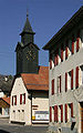
The Reformed Church of Bretonnières is one of the oldest stone churches in the canton of Vaud. The Romanesque nave dates from the 11th century, while the choir was built in the 14th and 15th centuries on the site of a round apse. The wall paintings are from the 16th century and the tower was built in 1906. In the center there are some farmhouses from the 18th and 19th centuries.

reformed Church

school
In the middle of the village


Web links
- Community information
- Germain Hausmann: Bretonnières. In: Historical Lexicon of Switzerland .
- Official website of the municipality of Bretonnières
- Aerial photography
Individual evidence
- ↑ Permanent and non-permanent resident population by year, canton, district, municipality, population type and gender (permanent resident population). In: bfs. admin.ch . Federal Statistical Office (FSO), August 31, 2019, accessed on December 22, 2019 .
L'Abbaye | L'Abergement | Agiez | Arnex-sur-Orbe | Ballaigues | Baulmes | Bavois | Belmont-sur-Yverdon | Bioley-Magnoux | Bofflens | Bonvillars | Bretonnières | Bullet | Chamblon | Champagne | Champvent | Chavannes-le-Chêne | Chavornay | Chêne-Pâquier | Le Chenit | Cheseaux-Noréaz | Les Clées | Concise | Corcelles-près-Concise | Cronay | Croy | Cuarny | Démoret | Donneloye | Ependes | Fiez | Fontaines-sur-Grandson | Giez | Grand event | Grandson | Juriens | Le Lieu | Lignette roll | Mathod | Mauborget | Molondine | Montagny-près-Yverdon | Montcherand | Mutrux | Novalles | Onnens | Orbe | Orges | Orzens | Pomy | La Praz | Premier | Provence | Rances | Romainmôtier-Envy | Rovray | Sainte-Croix | Sergey | Suchy | Suscévaz | Tévenon | Treycovagnes | Ursins | Valeyres-sous-Montagny | Valeyres-sous-Rances | Valeyres-sous-Ursins | Vallorbe | Vaulion | Villars-Epeney | Vugelles-La Mothe | Vuiteboeuf | Yverdon-les-Bains | Yvonand
Former municipalities: Arrissoules | Chanéaz | Corcelles-sur-Chavornay | Envy | Essert-Pittet | Essert-sous-Champvent | Fontanezier | Gossens | Gressy | Mézery-près-Donneloye | Prahins | Romainmôtier | Romairon | Vaugondry | Villars-Burquin | Villars-sous-Champvent
Canton of Vaud | Districts of the canton of Vaud | Municipalities of the canton of Vaud