
Valeyres-sous-Montagny
| Valeyres-sous-Montagny | |
|---|---|
 |
|
| State : |
|
| Canton : |
|
| District : | Jura north vaudois |
| BFS no. : | 5933 |
| Postal code : | 1441 |
| Coordinates : | 536 657 / 183 387 |
| Height : | 471 m above sea level M. |
| Height range : | 437-534 m above sea level M. |
| Area : | 2.28 km² |
| Residents: | 708 (December 31, 2018) |
| Population density : | 311 inhabitants per km² |
| Website: | www.valeyres-sous-montagny.ch |
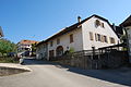
_021.JPG) Valeyres-sous-Montagny |
|
| Location of the municipality | |
  |
|
Valeyres-sous-Montagny is a municipality in the district of Jura-Nord vaudois in the canton of Vaud in Switzerland .
geography
Valeyres-sous-Montagny lies at 471 m above sea level. M. , 3 km northwest of the district capital Yverdon-les-Bains (air line). The cluster village extends slightly higher on the left northern slope of the Brine , west of Lake Neuchâtel , in the Vaudois Central Plateau .
The area of the 2.3 km² municipal area covers a section of the northern Vaud Central Plateau at the foot of the Jura . The southern border runs along the course of the Brine . From here, the municipality extends northward to the fertile plateaus at the foot of the Jura. In the far west, the area includes the Bois de Lily forest . At 533 m above sea level M. , east of the forest clearing Mornens, the highest point of Valeyres-sous-Montagny is reached. In 1997, 16% of the municipal area was accounted for by settlements, 22% for forests and woodlands and 62% for agriculture.
Valeyres-sous-Montagny has a new residential area south-east of the village and a few individual courtyards. The neighboring municipalities of Valeyres-sous-Montagny are Montagny-près-Yverdon in the south, Champvent in the west, Orges in the north-west, Giez in the north and Grandson in the east .
population
With 708 inhabitants (as of December 31, 2018), Valeyres-sous-Montagny is one of the smaller municipalities in the canton of Vaud. 93.8% of the residents are French-speaking, 2.6% German-speaking and 2.3% Italian-speaking (as of 2000). The population of Valeyres-sous-Montagny was 189 people in 1900. Since 1960 (197 inhabitants) a rapid population increase with a tripling of the number of inhabitants within 40 years has been registered.
economy
Valeyres-sous-Montagny was a predominantly agricultural village until the second half of the 20th century . Even today, the have farming and fruit growing an important role in the employment structure of the population. There is a small wine-growing area on a southern slope east of the village . Further jobs are available in local small businesses (including a mechanical workshop) and in the service sector. In the last few decades Valeyres-sous-Montagny has developed into a residential community. Numerous workers are therefore commuters who work primarily in the Yverdon area .
traffic
The community is very well developed in terms of traffic, although it is located off the main thoroughfares on a connecting road from Yverdon to Orges . The Yverdon-Ouest motorway junction on the A5 (Yverdon-Grandson) opened in 1984 is around 2 km from the town center. On November 27, 1893, the narrow-gauge railway Chemin de fer Yverdon - Ste-Croix with a station in Valeyres-sous-Montagny was put into operation.
history
A burial ground from the early Middle Ages was discovered in the municipality . The first written mention of the place took place in 1184 under the name de Valeres . The place name goes back to the Roman gender or personal names Valerius and Valeria and indicates finds from Roman times .
Since the 12th century, Valeyres-sous-Montagny shared the fortunes of the lordship of Montagny-le-Corbe, whose castle was on the spur south of the Brine, just opposite the village in the municipality of Montagny-près-Yverdon . After the Burgundian Wars , the village came under the administration of the Bailiwick of Grandson in 1476 , which was under the common rule of Bern and Friborg . After the collapse of the Ancien Régime , Valeyres-sous-Montagny belonged to the canton of Léman from 1798 to 1803 during the Helvetic Republic, which then became part of the canton of Vaud when the mediation constitution came into force . In 1798 it was assigned to the Yverdon district.
Attractions
In the old town center there are some stately farmhouses from the 17th to 19th centuries. Valeyres-sous-Montagny does not have its own church, it belongs to the parish of Montagny-près-Yverdon.

Parish hall

Entrance to the town with a level crossing
Farmhouse in the center of the village

Main road
_028.JPG)
_018.JPG)
_029.JPG)
_038.JPG)
Web links
- Official website of the municipality of Valeyres-sous-Montagny (French)
- Philippe Heubi: Valeyres-sous-Montagny. In: Historical Lexicon of Switzerland .
- Aerial views of the village
Individual evidence
- ↑ Permanent and non-permanent resident population by year, canton, district, municipality, population type and gender (permanent resident population). In: bfs. admin.ch . Federal Statistical Office (FSO), August 31, 2019, accessed on December 22, 2019 .
L'Abbaye | L'Abergement | Agiez | Arnex-sur-Orbe | Ballaigues | Baulmes | Bavois | Belmont-sur-Yverdon | Bioley-Magnoux | Bofflens | Bonvillars | Bretonnières | Bullet | Chamblon | Champagne | Champvent | Chavannes-le-Chêne | Chavornay | Chêne-Pâquier | Le Chenit | Cheseaux-Noréaz | Les Clées | Concise | Corcelles-près-Concise | Cronay | Croy | Cuarny | Démoret | Donneloye | Ependes | Fiez | Fontaines-sur-Grandson | Giez | Grand event | Grandson | Juriens | Le Lieu | Lignette roll | Mathod | Mauborget | Molondine | Montagny-près-Yverdon | Montcherand | Mutrux | Novalles | Onnens | Orbe | Orges | Orzens | Pomy | La Praz | Premier | Provence | Rances | Romainmôtier-Envy | Rovray | Sainte-Croix | Sergey | Suchy | Suscévaz | Tévenon | Treycovagnes | Ursins | Valeyres-sous-Montagny | Valeyres-sous-Rances | Valeyres-sous-Ursins | Vallorbe | Vaulion | Villars-Epeney | Vugelles-La Mothe | Vuiteboeuf | Yverdon-les-Bains | Yvonand
Former municipalities: Arrissoules | Chanéaz | Corcelles-sur-Chavornay | Envy | Essert-Pittet | Essert-sous-Champvent | Fontanezier | Gossens | Gressy | Mézery-près-Donneloye | Prahins | Romainmôtier | Romairon | Vaugondry | Villars-Burquin | Villars-sous-Champvent
Canton of Vaud | Districts of the canton of Vaud | Municipalities of the canton of Vaud