
Romont BE
| BE is the abbreviation for the canton of Bern in Switzerland and is used to avoid confusion with other entries of the name Romont . |
| Romont | |
|---|---|
 |
|
| State : |
|
| Canton : |
|
| Administrative district : | Bernese Jura |
| BFS no. : | 0442 |
| Postal code : | 2538 |
| Coordinates : | 592653 / 226597 |
| Height : | 907 m above sea level M. |
| Height range : | 654–1213 m above sea level M. |
| Area : | 7.02 km² |
| Residents: | 199 (December 31, 2018) |
| Population density : | 28 inhabitants per km² |
| Website: | www.romont-jb.ch |
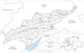
| Location of the municipality | |
  |
|
Romont is a municipality in the Bernese Jura administrative district in the canton of Bern in Switzerland . The German name Rothmund is only used locally today.
geography
Romont is 750 m above sea level. M. , 9 km northeast of Biel (linear distance). The former farming village extends on the eastern roof of the Jura chain of the Bözingenberg, in a panoramic position high above the plateau of the Swiss plateau .
The area of the 7.1 km² large municipal area includes the eastern slope and with a narrow tip the ridge height of the Bözingenberg ( 965 m above sea level ). To the north, the area extends over a syncline valley ( La Combe ), which has no running water, to the anticline of the Montagne de Romont ( 1190 m above sea level ). To the north of this ridge is the headwaters of the Terbez brook , which flows into the Schüss ( Suze in French ) near Péry . The northern border runs on the ridge of the Montoz chain, on which at 1210 m above sea level. M. the highest point of Romont is reached. On all three Jura ridges there are extensive Jura high pastures with the typical mighty spruce trees , which either stand individually or in groups. In 1997, 2% of the municipal area was in settlements, 60% in forests and woodlands, 37% in agriculture and a little less than 1% was unproductive land.
Several individual farms belong to Romont, which are widely scattered on the Jura heights. Neighboring communities of Romont are Court , Sorvilier , Péry-La Heutte , Sauge , Pieterlen and Lengnau in the canton of Bern and Grenchen in the canton of Solothurn .
population
With 199 inhabitants (as of December 31, 2018) Romont is one of the small communities in the Bernese Jura . Of the residents, 52.8% are French-speaking, 41.1% German-speaking and 2.5% Italian-speaking (as of 2000). The population of Romont was 195 in 1850 and 178 in 1900. Overall, growth has been recorded again in recent years.
politics
The voting shares of the parties at the 2015 National Council election were: SVP 55.1%, SP 21.8%, GPS 10.6%, BDP 7.0%, FDP 3.1%, EVP 0.6%, glp 0.5 %, CVP 0.4%.
economy
Romont is still mainly characterized by agriculture , with cattle breeding and dairy farming predominating, and there are also some fruit trees near the village . Local small businesses offer additional jobs. In the last few decades Romont has developed into a residential community. Many employed people are commuters and work in the city of Biel or in the Grenchen region .
traffic
The municipality is located off the major thoroughfares on the cantonal road from Frinvillier to Grenchen. The village is connected to the public transport network by the bus that runs from Biel to Romont.
history
The place name, first mentioned in 1311 as Redemont , is derived from the Latin word rotundus mons , 'round hill', 'round mountain'. Until 1797 the village belonged to the Erguel lordship , which was subordinate to the Duchy of Basel , although the city of Biel also exerted greater influence at times. From 1797 to 1815 Romont belonged to France and was initially part of the Mont-Terrible department , which was linked to the Haut-Rhin department in 1800 . By the decision of the Congress of Vienna , the place came to the canton of Bern to the administrative district of Büren in 1815 . At the request of the municipality of Romont, the village was assigned to the Courtelary district in 1841 .
Attractions
In the center of Romont there are some old farmhouses and houses from the 18th and 19th centuries.
Web links
- Official website of the municipality of Romont BE
- Christine Gagnebin-Diacon: Romont (BE). In: Historical Lexicon of Switzerland .
Individual evidence
- ↑ Permanent resident population from STAT-TAB of the BfS , municipalities see also regional portraits 2020 on bfs.admin.ch, accessed on May 29, 2020
- ↑ Results of the municipality of Romont BE. State Chancellery of the Canton of Bern, October 18, 2015, accessed on April 17, 2016 .
Belprahon | Champoz | Corcelles | Corgémont | Cormoret | Cortébert | Court | Courtelary | Crémines | Eschert | Grandval | La Ferrière | La Neuveville | Loveresse | Mont-Tramelan | Moutier | Nods | Orvin | Perrefitte | Péry-La Heutte | Petit-Val | Plateau de Diesse | Rebévelier | Reconvilier | Renan | Roches | Romont | Saicourt | Saint-Imier | Suction | Saules | Scolding (La Scheulte) | Seehof (Elay) | Sonceboz-Sombeval | Sonvilier | Sorvilier | Tavannes | Tramelan | Valbirse | Villeret
Former municipalities: Bévilard | Châtelat | This | La Heutte | Lamboing | Malleray | Monible | Péry | Plagne | Pontenet | Prêles | Sornetan | Souboz | Tramelan lingerie | Tramelan Dessus | Vauffelin
Canton of Bern | Administrative districts of the canton of Bern | Municipalities of the Canton of Bern