
Renan BE
| BE is the abbreviation for the canton of Bern in Switzerland and is used to avoid confusion with other entries of the name Renan . |
| Renan | |
|---|---|
 |
|
| State : |
|
| Canton : |
|
| Administrative district : | Bernese Jura |
| BFS no. : | 0441 |
| Postal code : | 2616 |
| Coordinates : | 561 346 / 219 771 |
| Height : | 907 m above sea level M. |
| Height range : | 823–1265 m above sea level M. |
| Area : | 12.63 km² |
| Residents: | 928 (December 31, 2018) |
| Population density : | 73 inhabitants per km² |
| Website: | www.renan.ch |
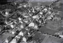
 View of Renan BE |
|
| Location of the municipality | |
  |
|
Renan is a municipality in the Bernese Jura administrative district in the canton of Bern in Switzerland . The former German name race is no longer used today.
geography
Renan lies at 907 m above sea level. M. , 8 km east-northeast of La Chaux-de-Fonds (linear distance). The village extends in the western upper part of the Jura Long Valley Vallon de Saint-Imier , on the left the Schüss ( French Suze ), on the lower southern slope of the Montagne du Droit .
The area of the 12.6 km² municipal area includes the uppermost section of the Vallon de Saint-Imier, which is drained by the Schüss. The central part is taken by the valley basin, which narrows towards the west. In the north the area extends to the anticline of the Montagne du Droit (on the ground of Renan up to 1080 m above sea level ). To the south, the community area extends to the northernmost crest of the chain of Mont d'Amin, which is divided into several sub-ridges . On this chain lies at 1265 m above sea level. M. the highest point of Renan. A small stream has carved the rock valley L'Embossu into the north flank through erosion . In the far west, the community extends to the slopes north of the Vue des Alpes pass . On the ridges of the Montagne du Droit and the Mont d'Amin chain there are extensive Jura high pastures with the typical mighty spruce trees , which either stand individually or in groups. In 1997, 6% of the municipal area was accounted for by settlements, 34% by forests and woodlands and 60% by agriculture.
Renan includes the scattered settlement of Les Convers , which includes numerous farmhouses along the road from Renan to the Vue des Alpes, as well as many individual farms that are widely scattered in the valley and on the Jura heights. Neighboring municipalities of Renan are La Ferrière and Sonvilier in the canton of Bern and Val-de-Ruz and La Chaux-de-Fonds in the canton of Neuchâtel .
population
| Population development | |
|---|---|
| year | Residents |
| 1850 | 1,820 |
| 1860 | 2,097 |
| 1900 | 1,746 |
| 1910 | 1,455 |
| 1930 | 1,176 |
| 1950 | 1,042 |
| 1960 | 1,091 |
| 1970 | 1,094 |
| 1980 | 882 |
| 1990 | 884 |
| 2000 | 836 |
With 928 inhabitants (as of December 31, 2018) Renan is one of the medium-sized communities in the Bernese Jura . Of the residents, 70.6% are French-speaking, 25.8% German-speaking and 1.1% Italian-speaking (as of 2000). The population of Renan reached its highest level as early as 1860. After that it decreased by over 50% by 1940 due to heavy emigration. After a phase of stagnation, a significant decline was recorded again in the 1970s as a result of the economic crisis. Since then, only minor fluctuations have been observed.
politics
The voting shares of the parties in the 2015 National Council election were: SVP 35.9%, SP 19.4%, GPS 13.2%, FDP 10.1%, BDP 7.3%, EDU 4.0%, EVP 3.1 %, Pirates 2.0%, PdA 1.9%, SD 1.0%, glp 0.9%, CVP 0.7%.
economy
Renan was mainly dominated by agriculture until the first half of the 19th century . After that, with the introduction of the watch industry, a rapid economic upswing set in. Renan suffered badly from the watchmaking crisis. Today there are jobs in watchmaking, in local trade, and agriculture still plays an important role, with cattle breeding and dairy farming predominating. Many workers are commuters and work in La Chaux-de-Fonds or in Saint-Imier .
traffic
The community is very well developed in terms of transport. It is located on the busy main road 30 from Biel to La Chaux-de-Fonds , which leaves the Vallon de Saint-Imier at Renan and rises to the height of La Cibourg. On April 30, 1874, the railway line from Biel to Convers was opened with a train station in Renan.
history
The first written mention of the village was made in 1178 under the name Runens . The Saint-Imier chapter owned real estate in Renan. During the Thirty Years War the place was looted and pillaged. Until 1797 the village belonged to the Erguel lordship , which was subordinate to the Duchy of Basel , although the city of Biel also exerted greater influence at times. From 1797 to 1815 Renan belonged to France and was initially part of the Mont-Terrible department , which was linked to the Haut-Rhin department in 1800 . As a result of the decision of the Congress of Vienna , the place came to the canton of Bern in the Courtelary district in 1815.
Attractions
The reformed village church was built between 1627 and 1630, and in 1885 a neo-Gothic bell tower was added. The townscape with a chessboard-like floor plan and cubic three- to four-storey houses from 1820-1850 shows the typical character of the villages of the upper Vallon de Saint-Imier and the northern part of the Val de Ruz . Some of the villas date from around 1900. Les Convers has numerous old farmhouses from the 17th and 18th centuries.
photos

View to the village center

SBB train station

reformed Church

Primary school / municipal administration

gym
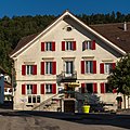
Cheval Blanc restaurant

Local, multi-storey stone cube house


Web links
- Official website of the municipality of Renan (French)
- Christine Gagnebin-Deacon: Renan (BE). In: Historical Lexicon of Switzerland .
Individual evidence
- ↑ Permanent resident population from STAT-TAB of the BfS , municipalities see also regional portraits 2020 on bfs.admin.ch, accessed on May 29, 2020
- ^ Results of the Renan Ward. State Chancellery of the Canton of Bern, October 18, 2015, accessed on April 17, 2016 .
Belprahon | Champoz | Corcelles | Corgémont | Cormoret | Cortébert | Court | Courtelary | Crémines | Eschert | Grandval | La Ferrière | La Neuveville | Loveresse | Mont-Tramelan | Moutier | Nods | Orvin | Perrefitte | Péry-La Heutte | Petit-Val | Plateau de Diesse | Rebévelier | Reconvilier | Renan | Roches | Romont | Saicourt | Saint-Imier | Suction | Saules | Scolding (La Scheulte) | Seehof (Elay) | Sonceboz-Sombeval | Sonvilier | Sorvilier | Tavannes | Tramelan | Valbirse | Villeret
Former municipalities: Bévilard | Châtelat | This | La Heutte | Lamboing | Malleray | Monible | Péry | Plagne | Pontenet | Prêles | Sornetan | Souboz | Tramelan lingerie | Tramelan Dessus | Vauffelin
Canton of Bern | Administrative districts of the canton of Bern | Municipalities of the Canton of Bern