
Malleray
| Malleray | ||
|---|---|---|
 |
||
| State : |
|
|
| Canton : |
|
|
| Administrative district : | Bernese Jura | |
| Residential municipality : | Valbirse | |
| Postal code : | 2735 | |
| former BFS no. : | 0697 | |
| Coordinates : | 587 296 / 232010 | |
| Height : | 699 m above sea level M. | |
| Area : | 10.35 km² | |
| Residents: | 1999 (December 31, 2014) | |
| Population density : | 193 inhabitants per km² | |
| Website: | www.valbirse.ch | |
 Malleray |
||
| map | ||
|
||


Malleray is a place in the municipality of Valbirse , which is in the Bernese Jura administrative district of the Swiss canton of Bern . Malleray formed its own political municipality until December 31, 2014 . The German name Malrein is no longer used today.
geography
Malleray is 699 m above sea level. M. , nine kilometers southwest of the town of Moutier (linear distance ). The village stretches across the wide valley floor of the Vallée de Tavannes , on both sides of the Birs and on the adjacent slopes of the Jura .
The area of the 10.4 square kilometer former municipal area comprises a section in the central part of the Vallée de Tavannes basin, which lies between two anticlines of the Chain Jura . To the north, the area extends to the ridge of the Moron , which is 1337 m above sea level. M. forms the highest point of Malleray. The southern slope of the Moron is very steep and crossed by a few limestone rocks. In the south, the former municipality extends to the height of the Montoz chain ( 1327 m above sea level ). On the two ridges of the Jura there are extensive high pastures with the typical mighty spruce trees , which either stand individually or in groups. In 1997, 9% of the former municipal area was accounted for by settlements, 45% for forests and woodlands and 46% for agriculture.
Several individual farms belong to Malleray. Malleray's neighboring municipalities are Reconvilier , Loveresse , Petit-Val , Champoz and Péry-La Heutte .
population
| Population development | |
|---|---|
| year | Residents |
| 1850 | 471 |
| 1900 | 1,224 |
| 1910 | 1,421 |
| 1930 | 1,298 |
| 1950 | 1,435 |
| 1960 | 1,838 |
| 1970 | 1,969 |
| 1980 | 1'908 |
| 1990 | 1,945 |
| 2000 | 1,854 |
With 1972 inhabitants (as of December 31, 2013) Malleray was one of the large municipalities of the Bernese Jura . 88.1% of the residents are French-speaking, 4.4% German-speaking and 3.1% Italian-speaking (as of 2000). Malleray's population rose sharply, especially in the 1960s. Only minor fluctuations have been recorded over the past 30 years. The village has grown together with the neighboring village of Bévilard .
economy
Malleray was an agricultural village until the second half of the 19th century , but then quickly developed into an industrial community. Today only 3% of the employed work in agriculture. With industrialization , machine and watch factories settled in the village. Today the companies in the precision engineering industry are of great importance.
traffic
The former community is well developed in terms of traffic. It is located on the busy main road from Delémont to Tavannes . In 2017, the A16 motorway was completed in the Vallée de Tavannes , which connects the Swiss national road network with the French motorway network. The through traffic leads past the village via a tunnel to the south.
On December 16, 1876, the Court to Tavannes railway was inaugurated. The station, called Malleray-Bévilard, is on the border between the two municipalities.
history

Remains of the Roman road were found in the former municipal area, which led from Biel over the Col de Pierre Pertuis to Malleray and on over the saddle from Champoz to Moutier.
The first written mention of the village under the name Malereie goes back to the year 1148, when Pope Eugene III. the monastery Moutier-Grandval confirmed the collection of tithes in Malleray. The name goes back to a derivation of the Latin mãlum 'apple' expanded with the double suffix -ārǐu and -ēta and means "near the apple grove ", "near the apple trees".
Under the Moutier-Grandval provost, Malleray was the main town of a Meieramt. A flood caused great damage in 1750. From 1797 to 1815 the village belonged to France and was initially part of the Mont-Terrible department , which was connected to the Haut-Rhin department in 1800 . Due to the decision of the Congress of Vienna , Malleray came to the Canton of Bern in 1815 , which assigned the place to the Moutier district.
The municipality of Malleray merged with the municipalities of Bévilard and Pontenet on January 1, 2015 to form the new municipality of Valbirse .
Attractions
Malleray's schoolhouse was built in 1905 in the Heimat style; the secondary school building dates from 1967. The modern Catholic church was built in 1971. On the ridge of the Moron there is an observation tower by architect Mario Botta , which was inaugurated in 2004.
Personalities
- Reynold Tschäppät (1917–1979), Mayor of Bern, born in Malleray

Grand-Rue

Spinning top

railway station

Primary school building
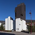
Catholic Church
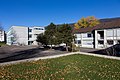
Secondary schools

old part of the village
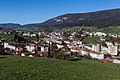
View of Bévilard-Malleray
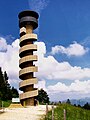
Tour de Moron


Web links
- Official website of the municipality of Malleray (French)
- Pierre-Olivier Léchot: Malleray. In: Historical Lexicon of Switzerland .
Individual evidence
- ↑ Lexicon of Swiss Community Names , ed. from the Center du Dialectologie at the University of Neuchâtel, Frauenfeld 2005, p. 565.
Belprahon | Champoz | Corcelles | Corgémont | Cormoret | Cortébert | Court | Courtelary | Crémines | Eschert | Grandval | La Ferrière | La Neuveville | Loveresse | Mont-Tramelan | Moutier | Nods | Orvin | Perrefitte | Péry-La Heutte | Petit-Val | Plateau de Diesse | Rebévelier | Reconvilier | Renan | Roches | Romont | Saicourt | Saint-Imier | Suction | Saules | Scolding (La Scheulte) | Seehof (Elay) | Sonceboz-Sombeval | Sonvilier | Sorvilier | Tavannes | Tramelan | Valbirse | Villeret
Former municipalities: Bévilard | Châtelat | This | La Heutte | Lamboing | Malleray | Monible | Péry | Plagne | Pontenet | Prêles | Sornetan | Souboz | Tramelan lingerie | Tramelan Dessus | Vauffelin
Canton of Bern | Administrative districts of the canton of Bern | Municipalities of the Canton of Bern