
Saules BE
| BE is the abbreviation for the canton of Bern in Switzerland and is used to avoid confusion with other entries of the name Saules . |
| Saules | |
|---|---|
 |
|
| State : |
|
| Canton : |
|
| Administrative district : | Bernese Jura |
| BFS no. : | 0707 |
| Postal code : | 2732 |
| Coordinates : | 583 407 / 232792 |
| Height : | 743 m above sea level M. |
| Height range : | 729–1247 m above sea level M. |
| Area : | 4.28 km² |
| Residents: | 151 (December 31, 2018) |
| Population density : | 35 inhabitants per km² |
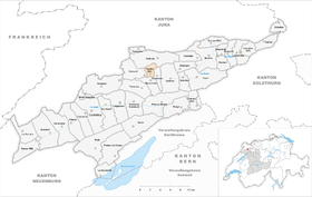
 Saules |
|
| Location of the municipality | |
  |
|
Saules is a municipality in the Bernese Jura administrative district in the canton of Bern in Switzerland .
geography
Saules lies at 743 m above sea level. M. , 13 km west-southwest of the village of Moutier (air line) and 12 km north of Biel / Bienne . The farming village extends in the Talniederung the creek Trame , a left tributary of the Birs , to the west of the Jura latitudinal valley de Vallee Tavannes .
The area of the 4.3 km² municipal area comprises a small part of the valley basin Vallée de Tavannes, which is up to 4 km wide here. Saules only includes the valley of the lower Trame and the adjacent height of Champ du Sautou ( 807 m above sea level ), which separates the rivers of the Trame and the Birs. To the north, the municipality extends over the steep slope of the Bois au Prince to the broad ridge of the anticlines of the Moron . On the Moron chain is at 1250 m above sea level. M. reached the highest point of Saules. Here there are extensive Jura high pastures with the typical mighty spruce trees , which either stand individually or in groups. In 1997, 3% of the municipal area was accounted for by settlements, 53% for forests and woodlands and 44% for agriculture.
Saules includes the hamlets of La Citadelle ( 768 m above sea level ) in a small side valley of the Trame at the foot of the Moron chain and Montagne de Saules ( 1054 m above sea level ) on the ridge of the Moron chain as well as several individual farms. The neighboring municipalities of Saules are Reconvilier , Saicourt , Petit-Val and Loveresse .
population
With 151 inhabitants (as of December 31, 2018), Saules is one of the small communities in the Bernese Jura . 91.5% of the residents are French-speaking, 7.9% German-speaking and 0.6% speak Albanian (as of 2000). The population of Saules was 143 inhabitants in 1850 and 212 in 1900. Especially after 1960 (202 inhabitants) a clear decline was recorded, but it has been stopped in recent years.
politics
The voting shares of the parties in the 2015 National Council election were: SVP 59.0%, SP 12.9%, EDU 9.5%, BDP 4.6%, GPS 4.0%, FDP 2.9%, EVP 2.7 %, SD 1.9%, glp 1.2%, Philipp Jutzi 1.2%, CVP 0.1%.
economy
Saules is still a mainly agricultural village, with dairy farming and cattle breeding as well as some fruit growing in the vicinity predominate. In the last few decades the village has also developed into a residential community. Outside of the primary sector there are hardly any jobs in Saules. Many workers are therefore commuters and work in the industrial communities of the Vallée de Tavannes.
traffic
The community is relatively easy to reach in terms of transport. It is located on the connecting road from Reconvilier to Le Fuet. Saules is connected to the public transport network by the bus line that runs from Tavannes via Lajoux to Les Genevez .
history
The first written mention of Saules dates back to 1148, when Pope Eugene III. the monastery Moutier real estate in sales confirmed. The Bellelay Monastery and the Principality of Basel also had the right to collect tithes from Saules . From 1797 to 1815 Saules belonged to France and was initially part of the Mont-Terrible department , which was linked to the Haut-Rhin department in 1800 . By the decision of the Congress of Vienna , the place came to the canton of Bern to the district of Moutier in 1815 .
Attractions

In the town center, some typical farmhouses from the 17th and 18th centuries, the building of the former school and an old village well have been preserved. Saules does not have his own church; it belongs to the Reconvilier-Chaindon parish.
Web links
- Christine Gagnebin-Deacon: Saules (BE). In: Historical Lexicon of Switzerland .
Individual evidence
- ↑ Permanent resident population from STAT-TAB of the BfS , municipalities see also regional portraits 2020 on bfs.admin.ch, accessed on May 29, 2020
- ^ Results of the Saules community. State Chancellery of the Canton of Bern, October 18, 2015, accessed on April 19, 2016 .
Belprahon | Champoz | Corcelles | Corgémont | Cormoret | Cortébert | Court | Courtelary | Crémines | Eschert | Grandval | La Ferrière | La Neuveville | Loveresse | Mont-Tramelan | Moutier | Nods | Orvin | Perrefitte | Péry-La Heutte | Petit-Val | Plateau de Diesse | Rebévelier | Reconvilier | Renan | Roches | Romont | Saicourt | Saint-Imier | Suction | Saules | Scolding (La Scheulte) | Seehof (Elay) | Sonceboz-Sombeval | Sonvilier | Sorvilier | Tavannes | Tramelan | Valbirse | Villeret
Former municipalities: Bévilard | Châtelat | This | La Heutte | Lamboing | Malleray | Monible | Péry | Plagne | Pontenet | Prêles | Sornetan | Souboz | Tramelan lingerie | Tramelan Dessus | Vauffelin
Canton of Bern | Administrative districts of the canton of Bern | Municipalities of the Canton of Bern