
Cortébert
| Cortébert | |
|---|---|
 |
|
| State : |
|
| Canton : |
|
| Administrative district : | Bernese Jura |
| BFS no. : | 0433 |
| Postal code : | 2607 |
| Coordinates : | 574876 / 226689 |
| Height : | 680 m above sea level M. |
| Height range : | 668–1393 m above sea level M. |
| Area : | 14.76 km² |
| Residents: | 705 (December 31, 2018) |
| Population density : | 48 inhabitants per km² |
| Mayor : | Manfred Bühler ( SVP ) |
| Website: | www.cortebert.ch |
 Cortébert |
|
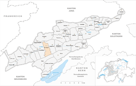
| Location of the municipality | |
  |
|
Cortébert is a municipality in the Bernese Jura administrative district in the canton of Bern in Switzerland .
geography
Cortébert is 680 m above sea level. M. , 12 km northwest of Biel (air line). The clustered village extends in the eastern part of the Jura Long Valley Vallon de Saint-Imier on both sides of the river Schüss ( French: Suze ).
The area of the 14.8 km² municipal area includes a section of the wide valley basin of the Vallon de Saint-Imier. The central part is the approximately 500 m wide valley low of the Schüss. In the north the area extends to the anticline of the Montagne du Droit (up to 1210 m above sea level ). To the south, Cortébert extends to the height of the Chasseral chain, at 1400 m above sea level. M. the highest point of the municipality is reached. At the top of the Chasseral chain, the hard cover rock was broken up and eroded away, creating a northern and a southern ridge over the course of millions of years. In between there is an anticline valley that has already been cleared to the next hard rock layer. This vault forms a third ridge between the two outer ridges. On the northern flank of the Chasseral chain, the Grabe brook , which flows into the Schüss at Cortébert, has carved the deep erosion valley Chenau de l'Envers . On the wide ridges of the Montagne du Droit and the Chasseral chain, especially on the Prés de Cortébert plateau , there are extensive Jura high pastures with the typical mighty spruce trees , which either stand individually or in groups. In 1997, 3% of the municipal area was in settlements, 47% in forests and woodland, 49% in agriculture and a little less than 1% was unproductive land.
Cortébert has numerous individual farms scattered across the valley and on the Jura heights. Cortébert's neighboring municipalities are Courtelary , Mont-Tramelan , Corgémont and Nods .
population
With 705 inhabitants (as of December 31, 2018), Cortébert is one of the medium-sized communities in the Bernese Jura . 73.8% of the residents are French-speaking, 18.6% German-speaking and 3.2% Italian-speaking (as of 2000). The population of Cortébert was 326 in 1850, and 871 in 1880. Since around 1900 it has always been in the area between 600 and 800 inhabitants.
politics
The Cortébert Riots. On March 16, 1980, 200 angry Pro Berners attacked four coaches with Jura delegates who were going to hold a meeting in the Hôtel de l'Ours. A journalist was seriously injured. The Bern canton police , which was under commandant Ernst Spörri, remained inactive. She waited until she could act - not against the lawbreakers, but against the Jurassians. Only thanks to direct intervention in the Bern government by Federal Councilor Kurt Furgler could worse be prevented. On the occasion of the 2015 National Council election, the voting shares of the parties were: SVP 43.8%, SP 23.7%, GPS 10.9%, BDP 5.5%, glp 3.4%, FDP 3.3%, EPP 2.4 %, CVP 2.2%, EDU 1.9%, PdA 1.6%, Philipp Jutzi 1.0%.
economy
Cortébert was an agricultural village until the middle of the 19th century , but there were also a few mills and cloth- making . In 1865, watch production took off with the opening of the Raiguel Juillard et Cie. (later renamed Cortébert Watch & Co) Fuss in Cortébert. The watch industry helped the place to an economic boom from the second half of the 19th century. With the crisis in the watch industry from around 1930, the smaller companies closed and in 1962 the Cortébert Watch was taken over by Omega SA. Production was finally stopped in the 1980s and the building was converted to residential use. An industrial and commercial zone has developed on the western edge of the village since 1990. Agriculture with cattle breeding and dairy farming , as well as some arable and fruit growing in the lower elevations , still play an important role. On the mountain heights there are several mountain taverns called "métairie" in French, which are located near the individual farms. In these typical restaurants, which are often found in the area, the guest can u. a. Enjoy a wonderful Berner platter, rösti or fondue jurassienne. The «métairie» is usually run by the farming family parallel to agriculture, with the restaurant not being the main activity.
traffic
The community has good transport links. It is located on the busy main road from Biel to La Chaux-de-Fonds . On April 30, 1874, the railway line from Biel to Convers was opened with a train station in Cortébert.
history

The village was first mentioned in writing in 1178 under the name Cortaibert , and in 1330 the spelling Corteber appears . The place name probably goes back to the personal name Agibertus . Cortébert belonged to the Moutier-Grandval chapter , with the Saint-Imier monastery also owning goods in the municipality. The Reformation was introduced in 1530 . Until 1797 the village belonged to the Erguel lordship , which was subordinate to the Duchy of Basel , although the city of Biel also exerted greater influence at times. From 1797 to 1815 Cortébert belonged to France and was initially part of the Mont-Terrible department , which was connected to the Haut-Rhin department in 1800 . As a result of the decision of the Congress of Vienna , the place came to the canton of Bern in the Courtelary district in 1815 .
Attractions
In the old village center south of the Schüss numerous farms and town houses from the 16th to 19th centuries have been preserved. The reformed chapel on the north side of the river was built in 1902.
photos

CFF / SBB train station
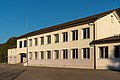
Schoolhouse and municipal administration

Multipurpose hall

Reformed chapel

Farmhouse

Farmhouse (1677)

Farmhouse

Bakery, post office

Milestone with distance in hours to Bern

Cortébert March 16, 1980: Bloody Sunday in the Bernese Jura


.jpg)
Web links
- Official website of the municipality of Cortébert
- Anne Beuchat-Bessire: Cortébert. In: Historical Lexicon of Switzerland .
Individual evidence
- ↑ Permanent resident population from STAT-TAB of the BfS , municipalities see also regional portraits 2020 on bfs.admin.ch, accessed on May 29, 2020
- ^ "Bloody Sunday in the Bernese Jura", Basler Zeitung, front page from March 17, 1980
- ↑ Marcel Schwander, Deutsch & Welsch, bridging the gap, Zyttglogge, 1991, pp. 102-105
- ^ "Did the constitutional state die in Cortébert?", Basler Zeitung, commentary from March 18, 1980 by Stefan Thomi, p. 2
- ^ Results of the municipality of Cortébert. State Chancellery of the Canton of Bern, October 18, 2015, accessed on April 17, 2016 .
Belprahon | Champoz | Corcelles | Corgémont | Cormoret | Cortébert | Court | Courtelary | Crémines | Eschert | Grandval | La Ferrière | La Neuveville | Loveresse | Mont-Tramelan | Moutier | Nods | Orvin | Perrefitte | Péry-La Heutte | Petit-Val | Plateau de Diesse | Rebévelier | Reconvilier | Renan | Roches | Romont | Saicourt | Saint-Imier | Suction | Saules | Scolding (La Scheulte) | Seehof (Elay) | Sonceboz-Sombeval | Sonvilier | Sorvilier | Tavannes | Tramelan | Valbirse | Villeret
Former municipalities: Bévilard | Châtelat | This | La Heutte | Lamboing | Malleray | Monible | Péry | Plagne | Pontenet | Prêles | Sornetan | Souboz | Tramelan lingerie | Tramelan Dessus | Vauffelin
Canton of Bern | Administrative districts of the canton of Bern | Municipalities of the Canton of Bern