Chatelat
| Chatelat | ||
|---|---|---|
| State : |
|
|
| Canton : |
|
|
| Administrative district : | Bernese Jura | |
| Residential municipality : | Petit Val | |
| Postal code : | 2715 | |
| former BFS no. : | 0684 | |
| Coordinates : | 581 519 / 235710 | |
| Height : | 802 m above sea level M. | |
| Area : | 4.09 km² | |
| Residents: | 105 (December 31, 2013) | |
| Population density : | 26 inhabitants per km² | |
| Website: | www.petit-val.ch | |
|
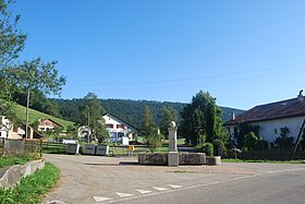
Châtelat village center with village fountain |
||
| map | ||
|
|
||
Châtelat is a village in the municipality of Petit-Val in the Bernese Jura administrative district in the Swiss canton of Bern .
Until December 31, 2014, Châtelat was a predominantly German-speaking political community . On January 1, 2015, Châtelat merged with the municipalities of Monible , Sornetan and Souboz to form the new municipality of Petit-Val .
geography
Châtelat is 802 m above sea level. M. , 13 kilometers west of Moutier (linear distance ). The street line village extends in the chain Jura on the upper Sorne , in a valley widening, which also bears the name Petit Val .
The area of the 4.1 square kilometer former municipal area comprises the westernmost section of the Petit Val on both sides of the Sorne. In the northwest, the area extends over the ridge of the Béroie (up to 1076 m above sea level ) to the height of Cernier de Rebévelier ( 1060 m above sea level ). To the south, the former municipal area extends over the wide Jura ridge of western Moron to the edge of the La Sagne moor , which extends south of Bellelay . On the ridge of the Moron is 1093 m above sea level. M. reached the highest point of Châtelat. Both on the Moron and on the Béroie you can find typical Jura high pastures with large spruce trees standing individually or in groups . The former municipal area is drained by the Sorne to the Birs . In 1997, 2% of the former municipal area was in settlements, 44% in forests and woodlands, 53% in agriculture and a little less than 1% was unproductive land.
Châtelat includes the hamlets of Fornet-Dessous ( 986 m above sea level ), on a saddle on the eastern edge of the Franches-Montagnes ( Freiberge in German ), and Moron ( 1002 m above sea level ) on the western roof of the Jura chain of the same name, as well as several individual farms . Neighboring communities of Châtelat are Saicourt and Rebévelier in the canton of Bern and Lajoux in the canton of Jura .
population
With 105 inhabitants (as of December 31, 2013) Châtelat was one of the small communities in the Bernese Jura . 63.9% of the residents are German-speaking and 36.1% French-speaking (as of 2000). The population of Châtelat was 153 in 1850 and 173 in 1900. After that, a downward trend was recorded overall.
The fact that the community is now mostly German-speaking is due to Mennonites who settled here on the Jura mountain ranges around 1570, such as on the Montagne du Droit (Sonnenberg) and the Montbautier (Stierenberg) with the permission of the Prince-Bishop of Basel .
economy
Châtelat is still a strongly agricultural village, with the dairy industry with cheese production ( Tête de Moine ) and cattle breeding being of particular importance. Outside the primary sector there are only a few jobs in the village. The few people who do not work in agriculture work in the communes of the Vallée de Tavannes.
traffic
The former municipality is located away from the larger thoroughfares on the cantonal road that leads from Tavannes via Bellelay through the Pichoux Gorge into the Delsberg basin near Bassecourt . Châtelat is temporarily served by a Postbus course , the next stop to be reached by the regular courses on the Tavannes – Lajoux– Les Genevez line is in Bellelay.
history
The village appears for the first time in 1335 under the name Schestellat in the documents. The first mention of the hamlet Fornet-Dessous goes back to the year 1181. Bellelay Monastery owned land in Châtelat and had the right to collect tithe . The village was under the Moutier-Grandval provost until the end of the 18th century . From 1797 to 1815 Châtelat belonged to France and was initially part of the Département du Mont-Terrible , which was connected to the Département Haut-Rhin in 1800 . Through the decision of the Congress of Vienna in 1815, the place came to the canton of Bern , which assigned it to the Moutier district. Under French rule, Fornet-Dessous was an independent community. Since January 1, 2015, Châtelat has been part of the Petit-Val municipality .
Attractions
In Châtelat there are still some typical farmhouses from the 18th and 19th centuries, the oldest granary dates from 1684. Fornet-Dessous also has a uniform appearance, as numerous houses fell victim to a village fire in 1829. The rebuilt houses, including the Hôtel du Sapin and the former school, show the architectural style of the first half of the 19th century.
Web links
- Petit-Val municipality website: Châtelat history and culture (French)
- André Bandelier: Châtelat. In: Historical Lexicon of Switzerland .
Individual evidence
- ↑ Christine Gagnebin-Deacon: Châtelat. In: Historical Lexicon of Switzerland .


