
Crémines
| Crémines | |
|---|---|
 |
|
| State : |
|
| Canton : |
|
| Administrative district : | Bernese Jura |
| BFS no. : | 0691 |
| Postal code : | 2746 |
| Coordinates : | 600081 / 236941 |
| Height : | 611 m above sea level M. |
| Height range : | 597–1248 m above sea level M. |
| Area : | 9.48 km² |
| Residents: | 509 (December 31, 2018) |
| Population density : | 54 inhabitants per km² |
| Website: | www.cremines.ch |
 Crémines |
|
| Location of the municipality | |
  |
|
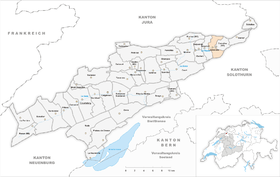
Crémines is a municipality in the Bernese Jura administrative district in the canton of Bern in Switzerland .
geography
Crémines is 616 m above sea level. M. , 5 km east of the village of Moutier (linear distance). The village extends along the La Raus stream in the Chain Jura , in the Cornet , the eastern part of the Moutier Jura Long Valley, which is also called the Grand Val .
The 9.4 km² municipal area covers a section of the Grand Val, which is bordered in the north by the Jura chain of Mont Raimeux . The central part of the area is formed by the valley basin through which the Raus flows, into which the Gaibiat brook flows from the right . In the north, the municipality extends over the limestone cliffs of Mont Raimeux to its high plateau. On this plateau are the typical Jura high pastures with large spruce trees standing individually or in groups . On the ridge of Mont Raimeux is at 1250 m above sea level. M. reached the highest point of Crémines. To the south, the municipal area extends into the Klus von Gänsbrunnen, a breakthrough valley that extends from the Oberdörferberg to the west (on the ground of Crémines in the Haute Joux 1169 m above sea level ) and to the east from the Walenmatt (up to 1200 m above sea level) . ) is flanked. In 1997, 4% of the municipal area was in settlements, 53% in forests and woodlands, 42% in agriculture and a little less than 1% was unproductive land.
The farm settlement Raimeux de Crémines ( 1116 m above sea level ) on the high plateau of Mont Raimeux as well as several individual farms belong to Crémines . Neighboring communities of Crémines are Grandval and Corcelles in the canton of Bern, Vermes and Courrendlin in the canton of Jura and Gänsbrunnen in the canton of Solothurn .
population
With 509 inhabitants (as of December 31, 2018), Crémines is one of the medium-sized communities in the Bernese Jura . 80.4% of the residents are French-speaking, 14.0% German-speaking and 1.7% Spanish-speaking (as of 2000). The population of Crémines was 297 in 1850 and 383 in 1900. In the further course, it always commuted between 490 and 580 people.
politics
The voting shares of the parties in the 2015 National Council election were: SVP 38.1%, SP 24.5%, BDP 8.3%, GPS 6.3%, EDU 4.9%, FDP 4.7%, CVP 4.0 %, glp 3.0%, EVP 2.6%, PdA 1.5%.
economy
The population of Crémines lived from agriculture until around 1900 , there was also watchmaking and pottery , mainly at home. With the growth of the machine tool industry in the Moutier valley, some companies also settled in Crémines. In the course of the 20th century, a cardboard box factory and the printing industry were added. Over the past few decades, Crémines has gradually developed into a residential community.
traffic
The community is very well developed in terms of transport. It is located on the main road from Moutier to Balsthal . On August 1, 1908, the Solothurn – Moutier line of the Solothurn-Münster Railway from Moutier through the Weissenstein tunnel to Solothurn was opened with a station in Crémines.
history

Crémines was first mentioned in writing in 1461 under the name Crimene , later the name Cremin appeared . However, the discovery of graves from the early Middle Ages indicates that the area was settled much earlier. Crémines was under the Moutier-Grandval provost until the end of the 18th century . From 1797 to 1815 Crémines belonged to France and was initially part of the Mont-Terrible department , which was linked to the Haut-Rhin department in 1800 . By the decision of the Congress of Vienna , the place came to the canton of Bern to the district of Moutier in 1815 . Since 1967 there has been a communal cooperation between the Cornet communities regarding water supply, wastewater treatment and primary school.
Attractions
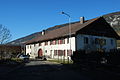
Some typical farmhouses from the 18th century have been preserved in the town center. The characteristic wooden granaries, which were built between the beginning of the 17th and the end of the 18th century, are also worth seeing. The restaurant de la Croix Blanche is located in a building that was constructed in 1810. The village schoolhouse , built in the late classicism style, dates from 1868 . Crémines is part of the Grandval parish. The Catholic chapel was built in 1935.
Others
In the municipality of this rather small village there are no fewer than four train stations on the Solothurn – Moutier route . In addition to the actual Crémines station and the Crémines Zoo stop, the Corcelles stop is located between these two in the municipality. At the southern end of the municipality's territory there is also the Gänsbrunnen station , which opens up the neighboring Solothurn municipality of the same name .
photos
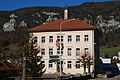
Old village school

Farmhouse
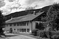
Residential house in Crémines

Renovated house
Typical house in Crémines
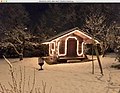
Typical granary from the first half of the 18th century in Christmas lights.


Personalities
- Samuel Gobat (1799–1879), Protestant bishop of Jerusalem
Web links
- Official website of the municipality of Crémines (French)
- François Wisard: Crémines. In: Historical Lexicon of Switzerland .
Individual evidence
- ↑ Permanent resident population from STAT-TAB of the BfS , municipalities see also regional portraits 2020 on bfs.admin.ch, accessed on May 29, 2020
- ^ Results of the municipality of Crémines. State Chancellery of the Canton of Bern, October 18, 2015, accessed on April 19, 2016 .
Belprahon | Champoz | Corcelles | Corgémont | Cormoret | Cortébert | Court | Courtelary | Crémines | Eschert | Grandval | La Ferrière | La Neuveville | Loveresse | Mont-Tramelan | Moutier | Nods | Orvin | Perrefitte | Péry-La Heutte | Petit-Val | Plateau de Diesse | Rebévelier | Reconvilier | Renan | Roches | Romont | Saicourt | Saint-Imier | Suction | Saules | Scolding (La Scheulte) | Seehof (Elay) | Sonceboz-Sombeval | Sonvilier | Sorvilier | Tavannes | Tramelan | Valbirse | Villeret
Former municipalities: Bévilard | Châtelat | This | La Heutte | Lamboing | Malleray | Monible | Péry | Plagne | Pontenet | Prêles | Sornetan | Souboz | Tramelan lingerie | Tramelan Dessus | Vauffelin
Canton of Bern | Administrative districts of the canton of Bern | Municipalities of the Canton of Bern