
Zuzwil BE
| BE is the abbreviation for the canton of Bern in Switzerland and is used to avoid confusion with other entries of the name Zuzwil . |
| Zuzwil | |
|---|---|
 |
|
| State : |
|
| Canton : |
|
| Administrative district : | Bern-Mittelland |
| BFS no. : | 0557 |
| Postal code : | 3303 |
| Coordinates : | 602 573 / 211183 |
| Height : | 565 m above sea level M. |
| Height range : | 538–602 m above sea level M. |
| Area : | 3.47 km² |
| Residents: | 578 (December 31, 2018) |
| Population density : | 148 inhabitants per km² |
| Website: | www.zuzwil-be.ch |
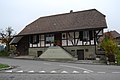
_087.JPG) Main street of Zuzwil |
|
| Location of the municipality | |
  |
|
Zuzwil is a municipality in the Bern-Mittelland administrative district in the canton of Bern in Switzerland .
geography

Zuzwil lies at 565 m above sea level. M. , 12 km north of the canton capital Bern (linear distance). The scattered village extends a scenic location in an opening to the south high dump on the slopes of Lerchenberges, in the eastern part of the Rapperswil plateau in the Swiss Plateau .
The area of the 3.5 km² municipal area covers a section of the gently undulating landscape of the central Bernese plateau. The slope of Zuzwil gently sloping towards the south and south-east with the height of the Lerchenberg ( 598 m above sea level ) and the Rüeggisbüel ( the highest point in Zuzwil at 601 m above sea level ) occupies the main part of the community. To the east, the municipality extends into the Silberenwald ( 565 m above sea level ) and to the edge of the Bollwald ; south into the swamp forest . The western demarcation forms the Woolibach , a source brook of the Urtenen , for long stretches . Only a small part of the municipal ban with the Geizmoos on the slope of the Oberholz lies west of this valley basin . In 1997, 8% of the municipal area was accounted for by settlements, 26% for forests and woodlands and 66% for agriculture.
Several individual farms belong to Zuzwil. Neighboring communities to Zuzwil are Iffwil , Jegenstorf , Deisswil bei Münchenbuchsee , Rapperswil .
history
The first written mention of the place took place in 1261 under the name of Zuzwiler . Later the names Zuzewile (1279), Zutzwilr (1302) and Zutzewile (1315) appeared. The place name could possibly by the agglutination of the preposition to have formed. It is therefore uncertain whether it goes back to the personal name Uzo or Zuzo .
With its first mention, Zuzwil came to the Knights of Schüpfen. Since the 14th century, both the Johanniter Commandery in Münchenbuchsee and the Cistercian convent Fraubrunnen had rich property in the village. In 1406, the sovereignty of the area came to Bern, and Zuzwil was assigned to the Zollikofen district court . After the collapse of the Ancien Régime (1798), the village belonged to the Zollikofen district during the Helvetic Republic and from 1803 to the Fraubrunnen Oberamt, which received the status of an official district with the new cantonal constitution of 1831.
population
With 578 inhabitants (as of December 31, 2018), Zuzwil is one of the small communities in the canton of Bern. 97.1% of the residents speak German, 1.3% speak French and 0.6% speak English (as of 2000). The population of Zuzwil was 282 in 1850 and 294 in 1900. In the course of the 20th century the population always fluctuated between 270 and 290 people. A significant increase in population has been recorded since 1960 (270 inhabitants).
politics
The voting shares of the parties in the 2015 National Council elections were: SVP 35.2%, BDP 23.7%, SP 12.6%, FDP 7.8%, GPS 6.1%, glp 5.3%, EPP 3.6 %, EDU 2.6%, CVP 2.4%.
economy
Up until the second half of the 20th century, Zuzwil was primarily a village characterized by agriculture and peat extraction with a Decauville peat railway . Even today, arable farming , fruit growing , livestock and dairy farming have an important place in the income structure of the population. Further jobs are available in local small businesses and in the service sector. In the last few decades the village has developed into a residential community thanks to its attractive location. Many workers are therefore commuters who mainly work in the Bern agglomeration.
Former peat track
| material | value |
|---|---|
| 3,205 m loose rails with brackets and bracket bolts of 42,050 kg a 0.65 SFR | 27,332.50 SFR |
| 9,000 rail nails of 1,085 kg at 1.50 SFR | 1,552.50 SFR |
| Packaging ( Swiss packaging ), freight, transport and directing hours for track laying etc. | 4,719.05 SFR |
| 638 pieces of wooden sleepers a 120.00 SFR and 670 pieces = 22.19 m³ a 77.00 SFR or 78.00 SFR per m³ including freight and transport | SFR 2,803.90 |
| Subtotal transport tracks | 36,407.95 SFR |
| 1944.4 m Decauville track, 600 mm gauge including brackets and bracket bolts, 33,557 kg a 0.95 SFR or 0.85 SFR per kg | SFR 30,601.15 |
| 503.9 m Decauville track 600 mm track complete a 24.00 SFR per running meter | SFR 12,093.00 |
| Freight & directing hours for transport & relocation | 1,368.90 SFR |
| Subtotal for 2,448.3 m of laying rails | CHF 44,063.05 |
| 8 points 5 m long 600 mm track a 1.60 SFR per kg resp. a 335.00 SFR per piece including freight etc. | SFR 2,458.40 |
| 19 turntables 600 mm track complete a 255.00 SFR or 280.00 SFR per piece including freight etc. | 5,346.15 SFR |
| Subtotal for turnouts and turntables | 7,804.55 SFR |
| 29 multi-storey peat trolleys, 600 mm track, each 247.00 SFR or 280.00 SFR per item including freight | 8,348.30 SFR |
| 15 tilting lorries 600 mm track a 250.00 SFR, 320.00 SFR or 350.00 SFR incl. Changes etc. | CHF 5,050.00 |
| Subtotal for rolling stock | 13,398.30 SFR |
| Total for track and rolling stock | 101,673.85 SFR |

A hand-operated Decauville railway was used in the peat field in Zuzwil . This was very suitable for the removal of the peat, because the peat field had a fairly even gradient of approx. 1% towards the loading ramp, so that the lorries rolled by themselves to the loading platform. The peat business was managed by entrepreneur August Josef, a peat specialist. Entrepreneur Joh. Josef managed the removal of the peat by truck or wagon to the railway and to other delivery points. The 6.5 km long transport route had longer gradients of 4 and 8%. At the Wil train station , the peat was shoveled directly into the wagons from the motor truck or cart. There was no special loading device there. The good monitoring and efficient implementation of the entire peat exploitation, the use of cheap labor and the management of the business by the entrepreneurs themselves are, among other favorable conditions, the main reason that the cost price of the peat on peat field Zuzwil is lower than on the other peat fields of the Swiss The peat cooperative failed.
traffic
The community is located off the major thoroughfares on a connecting road from Münchenbuchsee to Mülchi . The closest connection to the A6 motorway (Bern-Biel) is around 5 km from the town center. Zuzwil is connected to the public transport network through a Postbus course , which covers the route from Jegenstorf to Messen .
Attractions
Various characteristic farmhouses in the Bernese country style from the 17th to 19th centuries have been preserved in the old town center. Zuzwil does not have its own church, it belongs to the Jegenstorf-Urtenen parish.
photos

School building in Zuzwil

Zuzwil cheese dairy
Old cheese factory

Turn off to Jegenstorf
_066.JPG)
_081.JPG)
_080.JPG)
_088.JPG)
Web links
- Official website of the municipality of Zuzwil BE
- Anne-Marie Dubler : Zuzwil (BE). In: Historical Lexicon of Switzerland .
Individual evidence
- ↑ Permanent resident population from STAT-TAB of the BfS , municipalities see also regional portraits 2020 on bfs.admin.ch, accessed on May 29, 2020
- ↑ Elections 2015: Results of the community of Zuzwil. Canton of Bern, accessed on March 21, 2016
Allmendingen | Arni | Bäriswil | Belp | Bern | Biglen | Bolligen | Bowil | Bremgarten near Bern | Brenzikofen | Clavaleyres | Deisswil near Münchenbuchsee | Diemerswil | Ferenbalm | Fraubrunnen | Frauenkappelen | Open-leaved | Gerzensee | Grosshöchstetten | Guggisberg | Gurbrü | Membranous | Herbigen | Iffwil | Ittigen | Jaberg | Jegenstorf | Kaufdorf | Sweep | Gravel | Kirchdorf | Kirchlindach | Köniz | Konolfingen | Kriechenwil | Landiswil | Laupen | Linden | Mattstetten | Meikirch | Mirchel | Moosseedorf | Mühleberg | Münchenbuchsee | Münchenwiler | Münsingen | Muri near Bern | Neuenegg | Niederhünigen | Niedermuhlern | Oberbalm | Oberdiessbach | Oberhünigen | Oberthal | Oppligen | Ostermundigen | Riggisberg | Rubigen | Rüeggisberg | Rümligen | Rüschegg | Schwarzenburg | Stettlen | Thurnen | Toff | Urtenen-Schönbühl | Vechigen | Forest | Walk rings | Wichtrach | Wiggiswil | Wileroltigen | Wohlen near Bern | Worb | Zziwil | Zollikofen | Zuzwil
Former communities: Aeschlen bei Oberdiessbach | Albligen | Ausserbirrmoos | Ball moss | Perch wall | Belpberg | Bleiken near Oberdiessbach | Bremgarten City Court | Bümpliz | Büren to the yard | Englisberg | Etzelkofen | Gelterfingen | Golats | Grafenried | Gysenstein | Hoods | Innerbirrmoos | Church gymnastics | Limpach | Lohnstorf | Mädersforst | Measure barns | Mühledorf | Mill urns | Mülchi | Münchringen | Niederwichtrach | Noflen | Oberscheunen | Oberwichtrach | Otterbach near Oberdiessbach | Rüti near Riggisberg | Shells | Barns | Schlosswil | Schönthal | Stalden in the Emmental | Tägertschi | Trimstone | Electors | Zauggenried | Zimmerwald
Canton of Bern | Administrative districts of the canton of Bern | Municipalities of the Canton of Bern