
Gürbe
| Gürbe | ||
 Gürbe at Toffen |
||
| Data | ||
| Water code | CH : 471 | |
| location |
Mittelland
|
|
| River system | Rhine | |
| Drain over | Aare → Rhine → North Sea | |
| source | on the Nünenenberg on the northern slope of the Gantrisch 46 ° 42 ′ 43 ″ N , 7 ° 27 ′ 16 ″ E |
|
| Source height | approx. 1677 m above sea level M. | |
| muzzle | shortly before Wabern near Bern from the left into the Aare Coordinates: 46 ° 55 '32 " N , 7 ° 28' 13" E ; CH1903: 602 406 / 197 175 46 ° 55 '32 " N , 7 ° 28' 13" O |
|
| Mouth height | 505 m above sea level M. | |
| Height difference | approx. 1172 m | |
| Bottom slope | approx. 41 ‰ | |
| length | 28.7 km | |
| Catchment area | 143 km² | |
| Discharge at the Belp gauge , Mülimatt A Eo : 117 km² Location: 5.9 km above the mouth |
NNQ (1947) MNQ 1923–2013 MQ 1923–2013 Mq 1923–2013 MHQ 1923–2013 HHQ (1938 and 1957) |
100 l / s 1.35 m³ / s 2.61 m³ / s 22.3 l / (s km²) 4.13 m³ / s 59 m³ / s |
| Discharge A Eo : 143.05 km² at the mouth |
MQ Mq |
3.08 m³ / s 21.5 l / (s km²) |
The Gürbe is an approximately 29 km long left tributary of the Aare in the Swiss canton of Bern .
geography
course
The Gürbe rises with several source streams on the Nünenenberg on the northern slope of the Gantrisch . During the first 5 km it flows in an erosion funnel between the Gantrisch range in the south and the Gurnigel in the north to the northeast, overcoming a height difference of around 1000 m. The steep gradient made numerous stream barriers necessary in this section. In addition, the Gantrisch area is considered to be an area that is particularly often Sometimes heavy thunderstorms are afflicted, which can swell the Gürbe into a destructive torrent within a very short time .
The stream then carries its debris from the existing slate of the flysch zone and limestone rubble down to the plain. In the village of Blumenstein at the eastern foot of the Gurnigel, the Gürbe has formed an embankment cone. Here it reaches the lowlands of the wide valley between Thun and Bern , which was once carved out by the Ice Age Aare and Kander glaciers .

North of Blumenstein the Gürbe turns north and flows through the parallel to Aaretal extending Gürbetal that in the west of the heights of the Längenberg and the east by Belpberg flanked. This part of the Gürbe was corrected and straightened in the early 19th century.
At Belp it enters the actual Aare valley and forms, together with the Aare and the Giesse river, the Belpmoos, a level on which the Bern-Belp airport is located. Shortly before Wabern near Bern , it finally flows into the Aare.
Its approximately 28.7 km long run ends about 1172 meters below its source, so it has an average bed gradient of 41 ‰.
Catchment area
The 143.05 km² catchment area of the Gürbe is located in the Swiss Plateau and is drained to the North Sea via the Aare and the Rhine .
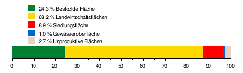
It consists of 24.3% planted area , 63.2% agricultural area , 8.9% settlement area , 1.0% water area and 2.7% unproductive areas.
The mean height of the catchment area is 804 m above sea level. M. , the minimum height is 504 m above sea level. M. and the maximum height at 2169 m above sea level. M.
Tributaries

- Ambachgrabe ( left )
- Marchgrabe ( right )
- Pasture grave ( right )
- Halbschlittegräbli ( right )
- Hindere Bruchgraben ( right )
- Front fracture ditch ( right )
- Schwändlibachgrabe ( left )
- Underwirtneregraben ( right )
- Bruchbach ( left )
- Honegggrabe ( left )
- Meierisligrabe ( left )
- Hasesprunggräbli ( right )
- Old Meierisligrabe ( left )
- Bärelochgrabe ( left )
- Chirschboumholebächli ( left )
- Chirschboumbächli ( left )
- Deep trench ( left )
- Chramloubegräbli ( right )
- Ledibodegrabe ( right )
- Chirschmattgrabe ( left )
- Steiegggrabe ( left )
- Mettlibach ( left )
- Fallbach ( right )
- Hirschbach ( right )
- Riedbächli ( right )
- Spengelibach ( left )
- Chriegsriedbächli ( right )
- Eybach ( left )
- Oligrabe ( left )
- Fellgrabe ( left )
- Oil grave ( left )
- Rotmettlebach ( left )
- Spitalgassekana ( right )
- Churzrütigrabe ( left )
- Hagikanal ( right )
- Mülibach ( left )
- Schlossbach ( left )
- Müsche ( right )
- Choufdorf Canal ( left )
- Ölibach ( right )
- Amselerbach ( right )
- Weierbodebach ( right )
- Toffekanal ( left )
- Hübeligrabe ( left )
- Greulebach ( right )
- Hofmattgrabe ( left )
- Aarbach ( left )
- Eisselgrabe ( right )
- Backrest channel ( left )
- Gurtedorfbach ( left )
Hydrology
Discharge data
At the confluence of the Gürbe in the Aare, the modeled mean flow rate (MQ) is 3.08 m³ / s. The discharge regime type is pluvial supérieur and the discharge variability is 24.

Flood
Gürbe correction and flood protection measures
At the end of the 18th century, after several floods, a water correction of the section in the Gürbetal was discussed more intensely. In 1854, the Grand Council of the Canton of Bern decided to implement the Gürbe correction. A first stage was completed in 1860. In 1911 most of the work was completed. Nevertheless, there have always been floods to this day. Since then, the Gürbe has presented itself in the Gürbetal as a straightened, canalized river with fortified banks. After another flood in 1995, the Gürbe estuary was renovated in 2006 as part of the Aare flood protection and the floodplains were revitalized. Further flood protection measures (barriers) were implemented in the period from 2007 to completion in May 2009.
Gürbe floods of 1990
On the evening of July 29, 1990, around 500 mm of hail and 300 mm of rain discharged in the Gürbe catchment area, which, with a retrospectively calculated 200–250 m 3 / s, led to three times the amount of runoff values of 70 m 3 / s declared as a century event . The resulting floods swept away the old wooden whitewater barriers that came from the beginning of the 20th century. The amount of water also lowered the bottom of the stream bed (in some places by almost 8 meters). Before the curve on the alluvial cone above Wattenwils , the water finally jumped out of the creek bed and poured - together with the debris and the remains of the structures - towards Blumenstein and Wattenwil.
The rubble collectors and alluvial cones above Blumenstein could no longer contain the masses. Driftwood and the remains of the structures were swept away by the floods and caused great damage to the lower Gürbetal. The floods caused damage of an estimated 40 million Swiss francs. The Gürbetalbahn had to cease operations for two weeks because the water washes away from the tracks. The fish population was almost completely destroyed by the flood and had to be replenished.
As a result of the flooding, the Gürbe above Wattenwil was corrected again, the existing bottle necks removed and designed for larger water volumes of 160 - 200 m 3 / s including attachments.
Web links
- Anne-Marie Dubler : Gürbe. In: Historical Lexicon of Switzerland .
- Current discharge values of the Burgistein station (7 days), Office for Water and Waste, Canton of Bern (PDF; 11 kB)
Individual evidence
- ↑ a b c Geoserver of the Swiss Federal Administration ( information )
- ↑ Water network in the WebGis geographic information system of the canton of Bern
- ↑ a b Belp measuring station, Mülimatt 2013 (PDF) Federal Office for the Environment FOEN
- ↑ a b Topographical catchment areas of Swiss waters: Gürbe
- ↑ "Hidden behind the mean values" - the variability of the discharge regime , p. 7
- ↑ The discharge variability describes the extent of the fluctuations in the mean discharge of individual years around the long-term mean discharge value.
- ↑ https://www.derbelper.ch/wp-content/uploads/2017/11/der_belper_10_07.pdf
- ↑ Herbert Rentsch: Why the Gürbe is dead straight. In: bernerzeitung.ch . July 20, 2016, accessed July 27, 2019 .
- ↑ ( page no longer available , search in web archives )