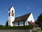
List of cultural assets in Rüti near Büren
The list of cultural assets in Rüti bei Büren contains all objects in the municipality of Rüti bei Büren in the canton of Bern that are subject to the Hague Convention for the Protection of Cultural Property in the Event of Armed Conflict , the Federal Act of June 20, 2014 on the Protection of Cultural Property in the Event of Armed Conflicts and the Ordinance of October 29, 2014 on the Protection of Cultural Property in the Event of Armed Conflict .
Objects of category A are not shown in the municipality, objects of category B are fully included in the list, objects of category C are currently missing (as of January 1, 2018). Among other monuments objects are found, the "worthy of protection" in the canton of Bern Bauinventar than are listed.
Cultural assets
| photo | object | Cat. | Type | Location | description |
|---|---|---|---|---|---|

|
Reformed church with rectory KGS-No .: 1194 |
B. | G |
Herrengasse 2-4 597355 / 222340 |
The core of the church building dates back to the 12th century with a cheese bite tower that was added later . The white plastered building with tuff structure and a slightly drawn-in, rectangular choir under a bent gable roof stands in a walled churchyard. The Romanesque nave has Gothic paintings from the 15th century. Next to it is the rectory , built in 1787 , a very stately plastered building with symmetrical, three-axis facades under a bent full hipped roof .
|

|
Teufelsburg , ramparts KGS no .: 1195 |
B. | G | Rütiwald five hundred and ninety-nine thousand and ninety / 221830 |
From the Mottenburg built in the 10th and 11th centuries , moats and walls up to five meters high have been preserved. The castle hill is 15 meters high and is leveled at the top. The resulting circular area measures 13 meters in diameter. Together with the earthwork , the system measures 150 meters in diameter. |
Other monuments
| ID | photo | object | Type | address | Coordinates |
|---|---|---|---|---|---|
| 63 | Former inn (1868) | G | Steinäcker 4 |
597736 / 222414
|
|
| 74 |

|
Pfrundspeicher (17th century) | G | Herrengasse 4a |
597344 / 222277
|
| 120 | Lower Mill (1868) | G | Mühlegasse 11 |
597560 / 222159
|
|
| 124 | Mühlestöckli (1816) | G | Mühlegasse 2 |
597526 / 222136
|
|
| 137 | Farmhouse (1842) | G | Bahnhofstrasse 19 |
597244 / 222563
|
|
| 170 | Former farmhouse (18th century) | G | Herrengasse 17 |
597393 / 222043
|
|
| 194 | Former farmhouse (1832) | G | Solothurnstrasse 10 |
597546 / 222465
|
|
| 223 | Farmhouse (1840) | G | Wüschbach 1 |
596516 / 221426
|
|
| 227 | Farmhouse (1794) | G | Solothurnstrasse 5 |
597410 / 222454
|
|
| 233 | Former school building (around 1780/90) | G | Herrengasse 3 |
597388 / 222311
|
|
| 342 | Mühlestöckli (2nd half of the 18th century) | G | Mühlegasse 4 |
597560 / 222113
|
|
| 530 | Memory (1699) | G | Solothurnstrasse 7a | 597441 / 222475 |
Web links
- A objects BE 2018 . Swiss inventory of cultural assets of national importance. In: babs.admin.ch / kulturgueterschutz.ch. Federal Office for Civil Protection FOCP - Department of Cultural Property Protection, January 1, 2018, accessed on December 26, 2017 (PDF; 212 kB, 47 pages, updated annually, the changes for 2018 are marked in blue).
- B objects BE 2018 . Canton of Bern KGS inventory, B objects, status: 2009, unadjusted (1.1.2018; municipal mergers for 2018 are marked in blue). In: babs.admin.ch / kulturgueterschutz.ch. Federal Office for Civil Protection FOCP - Department of Cultural Property Protection, January 1, 2018, accessed on December 30, 2017 (PDF; 344 kB, 11 pages, updated annually, the changes for 2018 are marked in blue).
- Bauinventar-Online Monument Preservation of the Canton of Bern
Individual evidence
- ↑ Federal Chancellery : Federal Act on the Protection of Cultural Property in the Event of Armed Conflict, Disaster and Emergencies (KGSG). SR 520.3. In: Systematic Legal Collection SR . Federal Assembly of the Swiss Confederation , June 20, 2014, accessed on August 20, 2017 (as of January 1, 2016).
- ^ Federal Chancellery : Ordinance on the Protection of Cultural Property in the Event of Armed Conflicts, Disasters and Emergencies (KGSV). SR 520.31. In: Systematic Legal Collection SR . Swiss Federal Council , October 29, 2014, accessed on August 20, 2017 (as of January 1, 2016).
- ↑ Herrengasse 2. (PDF) Building inventory of the Canton of Bern, November 22, 2017, accessed on December 15, 2019 .
- ↑ Herrengasse 4. (PDF) Building inventory of the Canton of Bern, November 22, 2017, accessed on December 15, 2019 .
- ^ Thomas Bitterli-Waldvogel: Castle Map of Switzerland - West . Object description and detailed maps. Ed .: Swiss Castle Association. Federal Office for Topography swisstopo, Wabern 2007, ISBN 978-3-302-09801-2 , p. 42 .