
Engelberg
| Engelberg | |
|---|---|
 |
|
| State : |
|
| Canton : |
|
| District : | No district division |
| BFS no. : | 1402 |
| Postal code : | 6388 (Grafenort) 6390 (Engelberg) |
| UN / LOCODE : | CH ENG |
| Coordinates : | 673 573 / 185971 |
| Height : | 1015 m above sea level M. |
| Height range : | 556–3238 m above sea level M. |
| Area : | 74.87 km² |
| Residents: | 4181 (December 31, 2018) |
| Population density : | 56 inhabitants per km² |
|
Proportion of foreigners : (residents without citizenship ) |
28.3% (December 31, 2,015) |
| Website: | www.gde-engelberg.ch |
 Monastery and part of the old town center of Engelberg |
|
| Location of the municipality | |
  |
|
Engelberg is a municipality in the canton of Obwalden in central Switzerland .
The place goes back to the Benedictine Abbey of Engelberg Monastery, founded in 1120 , and is an exclave of the canton of Obwalden, surrounded by the cantons of Bern , Nidwalden and Uri . Engelberg is a place of summer and winter tourism.
geography

Engelberg is located 25 km south of Lake Lucerne and 20 km south of the village of Stans , in a flat, wide high valley at an altitude of around 1000 m. The place is enclosed between the massif of the 3238 m high Titlis in the south and a mountain range in the north, the high of the up to 2,800 m mountains Engelberger Rostock , Ruchstock , Rigidalstock and Walenstoecken is formed. In the east, the Hahnen, enthroned directly above the town, dominates the townscape with a height of 2600 m.
The flat valley floor of Engelberg was created at the end of the last Ice Age , when a huge rock fall from the Titlis blocked the valley exit to the northwest. The resulting natural reservoir was filled within a few thousand years with rubble and sand, which was brought in from the Engelberger Aa and its tributaries from the neighboring mountains. Today only the small Lake Eugenisee , which is artificially regulated for electricity generation, reminds of the former mountain lake . Below it, the stream plunges into the Aa Tobel , where the steep terrain is subject to severe erosion and isolated landslides to this day.

The municipality of Engelberg also includes Grafenort (570 m above sea level) , located below the Aaschlucht gorge in the lower Engelberg valley near Wolfenschiessen .
The Horbistal, which branches off north of the main valley with the Bärenbach, ends abruptly below a steep rock face. This place bears the pictorial name End der Welt .
Upstream, the Engelberger Aa valley continues to the east and later to the northeast for around 15 km to the 2291 m high Surenen Pass .
Only 3.1% of the entire municipal area is settlement area. Large parts of the community area are covered with wood and forest (24.5%) or are used for agriculture - often as Alps (28.5%). Far more are unproductive areas, mostly mountains (43.9%).
Climate table
| Engelberg, 1981-2010 | ||||||||||||||||||||||||||||||||||||||||||||||||
|---|---|---|---|---|---|---|---|---|---|---|---|---|---|---|---|---|---|---|---|---|---|---|---|---|---|---|---|---|---|---|---|---|---|---|---|---|---|---|---|---|---|---|---|---|---|---|---|---|
| Climate diagram | ||||||||||||||||||||||||||||||||||||||||||||||||
| ||||||||||||||||||||||||||||||||||||||||||||||||
|
Average monthly temperatures and precipitation for Engelberg, 1981–2010
Source:
|
||||||||||||||||||||||||||||||||||||||||||||||||||||||||||||||||||||||||||||||||||||||||||||||||||||||||||||||||||||||||||||||||||||||||||||||||||||||||||||||||||||||||||||||||||||
history


Economically, the basis of the valley was agriculture, with Engelberg belonging to what is known as the shepherd's country of Central Switzerland, where arable farming was abandoned early on and all agriculture was based on cattle farming and the export of hard cheese, mainly to northern Italy. Therefore, the agricultural activity was strongly influenced by the seasons, with alpine upheaval and downheaval and additional mowing to obtain hay for the winter. The Engelbergers took in large numbers of guest cattle in the summer, which were herded from Nidwalden and, in some cases, beyond into the valley for the summer in the Alps. In the seasons of the year with less work, many people in the valley acted as mules and transported the cheese and other goods they produced themselves as far as Italy and at the same time traded in Italian goods in central Switzerland.
Engelberg was when facing site of the Old Confederacy part of the Holy Roman Empire. Political rule was exercised by the Benedictine Abbey of Engelberg Monastery , founded around 1120 by Baron Konrad von Sellenbüren , due to a royal award. This is how all legal historical works on the history of Central Switzerland describe it. The residents viewed their situation significantly differently, as evidenced by an evaluation of the valley logs. After the valley inhabitants fought against Zwingli in the Battle of Kappel with the Waldstätten in 1531 , they saw themselves as having equal rights with the Confederates . Even if the Landsgemeinde constitution was only valid in the Waldstätten (except Lucerne), the residents of the Engelberg Valley claimed the rights from it for themselves.
In practice, the citizens exercised political rule themselves in the form of various municipal assemblies. The abbots of the monastery were clever enough never to insist on their royal rights; simply through the predominance of landed property in all congregations on subjects that directly affected land, they had such a strong position that an appeal to formal rule was not possible was required.
The highest assembly was the valley church . It was only convened when needed, in some years several times a year, at other times there were more than ten years between two valley communities. The nine court lords of the valley were determined in the valley parish, and their term of office was valid until the next parish. In difficult cases, the valley community was also able to appoint a district administrator , who, in addition to the court lords, included 18 other valley citizens. The district administrator was in office or with the next municipality until his task was completed. In addition, the valley community appointed the sack master who supervised the Talkästli . In this all the documents of the valley were recorded, so that this was an extraordinary position of trust but without actual political power.
There were valley community assemblies for various tasks, to which only those affected were called. This includes the trading community of all those involved in the trade and the night watchman communities of the individual settlement centers. Every year on St. Thomas's Day , December 21st, a call was made to the comrades congregation . After the end of the alpine season, all the owners and users of the four alpine communities in the valley took part, settled the accounts for the past year and laid down the principles for the management of the next year.
The medieval monastery was destroyed by fires several times, most recently on August 29, 1729 by fireworks by students, but has continued to this day without interruption. In addition, the plague - most recently in 1628/29 - and political disputes in the High and Late Middle Ages struck the valley several times. When the plague broke out in 1628/29, the Mühlematt farm changed hands three times within a year, after the owners Hans and Balz Häcki each died of the plague. Bernardin Häcki, a wealthy free valley farmer, had acquired the farm from the monastery in 1585 for 930 Lucerne guilders and for 2 plappert annual land rent.
The name Engelberg goes back to a legend according to which angel voices from the height of the Hahnen mountain initiated the foundation of the abbey. The angel appears in the town's coat of arms. The monastery community ( comprising monks and nuns as a double monastery until 1615 ) became the nucleus of a spiritual miniature state, which was established in the 13th and 14th centuries. Century placed under the auspices of the Confederates. She founded a monastery, scribe and painting school, from which today's Engelberg Abbey School developed and made the valley famous beyond the borders of Switzerland. With increasing worldly desire for freedom, the monastery gradually began to cede certain privileges from the 15th century.
In 1797–1798, as a result of an invasion by French troops, the Old Confederation collapsed . On March 1, 1798, the monastery renounced its rulership rights over the Engelberg Valley: like Obwalden, it adopted the new Helvetian constitution , which provided for legal equality and the separation of powers. Nidwalden, on the other hand, resisted the new form of government. A summer full of tension and threats from the canton of Nidwalden followed. The canton asked the Engelberg community in vain to join the resistance. This was bloodily suppressed by French troops in September 1798. After Napoleon's defeat in the Battle of Leipzig in 1813, the new constitution created by France was repealed. Some cantons, including Nidwalden, called for a return to a constitution based on estates. In 1815, however, a new federal treaty was passed, which all cantons signed up to - with the exception of Nidwalden, which became increasingly radicalized, probably under the influence of the trauma of 1798. The valley community Engelberg then decided to separate from Nidwalden and joined the canton of Obwalden in a preliminary agreement in July 1815. In August 1815, the invasion of federal troops put the Nidwalden resistance to a bloodless end. In November 1815, with the binding incorporation contract, Engelberg finally became an Obwalden exclave.
Tourism began in the middle of the 19th century and became the determining economic factor in the 20th century. Several hotel complexes were built, as well as a spa hall and a spa park . In 1898 Engelberg was developed from Stansstad with the Stansstad – Engelberg Railway , the first electric rack railway . This opening to the outside world also pushed back the social influence of the monastery.
In the 1920s, an agricultural crisis led some families to emigrate to Upper Austria . In 1938 the Alpine World Ski Championships took place in Engelberg .
population
Population development
The number of inhabitants in the municipality grew strongly between 1709 and 1850 (1709-1850: + 156.2%). The reason for this was a large excess of births. The first wave of emigration occurred between 1850 and 1860 (1850-1860: −4.1%). In 1870 the population was back at the level of 1850. The emerging tourism caused a population increase in the 1870s. This was followed by two decades of stagnation. Before the First World War, there was a large increase in the population (1900–1910: + 22.6%). The construction of the Stansstad – Engelberg Railway (line opened in 1898) and the onset of winter tourism (from 1903) led to this. The tourism crisis then led to a second population decline (1910–1920: −4.5%). After the end of the Second World War until 1980, there was a strong growth phase (1941–1980: +23.0%). After a phase of stagnation in the 1980s, the population rose sharply (1990–2010: +31.9%).
The reasons for the increase were the improvement in the public transport service (direct train connection from Lucerne to Engelberg from 1964) and the construction of the A2 .

Population development of Engleberg since 1709. Source: local and cantonal censuses, federal censuses (1850–2000), Federal Statistical Office (2010)
languages
The population speaks a highly Alemannic dialect. The regional dialect (own character due to the location) is still spoken frequently. In the last census in 2000, 88.2% said German, 2.48% Serbo-Croatian and 2.17% English as their main language.
Religions - denominations

Until a few decades ago, almost the entire population was Catholic. The secession of the church and the heavy immigration from other parishes and abroad has led to a rapid increase in other denomination groups in Engelberg. The denominational relationships in 2000 still show the original structure despite the mixture. 2,533 people were Catholic (71.47%). There were also 12.25% Protestant and 4.03% Orthodox Christians, 1.61% Muslims and 3.70% non-denominational. 222 people (6.26%) did not provide any information about their creed.
Origin - nationality

Of the 4,181 residents at the end of 2018, 3,096 (74.05%) were Swiss citizens. The majority of the immigrants come from Central Europe (Germany 273, United Kingdom 42, Netherlands 35 and Austria 28 people), Southern Europe (Portugal 206, Italy 42 and Spain 34 people), the former Yugoslavia (Bosnia-Herzegovina 56, Kosova 16 and Croatia 14 people ), Sweden (64 people), Africa (Eritrea 15 people) and Asia (Sri Lanka 14, China 13 and India 12 people). At the 2000 census, 2,886 people (81.4%) were Swiss citizens; 138 of them had dual citizenship.
age structure
The church had a high proportion of middle-aged people in 2000. While the proportion of people under the age of twenty made up 26.24% of the local population, 20.60% were senior citizens (60 years and older). The largest age group is made up of people between 30 and 44 years of age.
The age structure of the 2000 census was as follows:
| Age | 0–6 years | 7-15 years | 16-19 years | 20-29 years | 30–44 years | 45–59 years | 60–79 years | 80 years and more |
| number | 273 | 414 | 243 | 455 | 833 | 596 | 584 | 146 |
| proportion of | 7.70% | 11.68% | 6.86% | 12.84% | 23.50% | 16.82% | 16.48% | 4.12% |
The community now has a high proportion of middle-aged residents. While the proportion of people under the age of twenty makes up 16.55% of the local population, 29.37% are senior citizens (60 years and older). The largest age group are people between 45 and 59 years. For every 100 people of working age (20–64 years; 2550 people) there are 27 young people (692 people) and 37 people (939 people) of retirement age.
The following age structure emerged at the end of 2018:
| Age | 0–6 years | 7-15 years | 16-19 years | 20-29 years | 30–44 years | 45–59 years | 60–79 years | 80 years and more | |||
| number | 213 | 323 | 156 | 481 | 775 | 1005 | 979 | 249 | |||
| proportion of | 5.09% | 7.73% | 3.73% | 11.50% | 18.54% | 24.04% | 23.42% | 5.96% | |||
| Source: Federal Statistical Office, population by age at the end of 2018 | |||||||||||
politics
Engelberger Talammann has been Alex Höchli ( CVP ) since 2016 .
economy
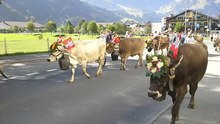

Large valley and alpine pastures are available in the valley floor itself and on the surrounding heights . Alpine dairy farming, which has been the determining economic factor for centuries, is still practiced today, partly with the help of state subsidies. In summer, the ringing of the cowbells always determines the background noise in the mountains, and both in the local dairies and in the dairies in the Alps you can try the local cheese, for example Sbrinz or goat cheese, and buy it directly from the producer.
With 854,502 overnight stays in 2018, tourism is the determining economic factor in the valley. Engelberg ranks 6th among the destinations in the Alpine region in the BAK TOPindex 2009 of BAKBASEL .
In Engelberg there were (2008) 1,990 employees in 326 companies. 8.5% of the employees in Engelberg worked in agriculture / forestry / fishing (sector 1), 11.8% in industry and trade (sector 2) and 79.7% in service companies (sector 3). The unemployment rate in 2011 was 1.09%.
In 2000 there were 1,914 people in employment in Engelberg. Of these, 1,561 (81.56%) were locals and 353 were commuters. Most of the commuters came from the region; namely from Wolfenschiessen (22.7%), Dallenwil, Oberdorf and Stans (8.5% each), the city of Lucerne (6.5%) and Buochs (5.7%). In the same year, 1,864 people from Engelberg were gainfully employed. Thus 302 people worked in other communities. 70 people (= 23.2% of all commuters) commuted to the main town of Nidwalden, Stans, 48 people (15.9%) to the city of Lucerne, 15 people (5.0%) to Stansstad, 14 people (4.6%) to Sarnen %), to Emmen, Hergiswil and Wolfenschiessen, 12 people each (4.0% each).
In 2017, 1314 of the 2567 employees were male and 1253 female. The numbers for the 3 sectors are as follows:
| Companies 1st sector |
Employees 1st sector |
Full-time positions 1st sector |
Companies 2nd sector |
Employees 2nd sector |
Full-time positions 2nd sector |
Companies 3rd sector |
Employees 3rd sector |
Full-time positions 3rd sector |
Operations total |
employees Total |
Total full-time positions |
|
| number | 55 | 166 | 104 | 53 | 265 | 215 | 389 | 2136 | 1567 | 497 | 2567 | 1887 |
| proportion of | 11.07% | 6.47% | 5.51% | 10.66% | 10.32% | 11.39% | 78.27% | 83.21% | 83.04% | 100% | 100% | 100% |
| Source: Federal Statistical Office; Statistics of the company structure STATENT, workplaces and employees by municipality and economic sector | ||||||||||||
traffic


The only natural access leads from the north, from the lower Engelberg valley, over 5 km of path length and 500 meters of altitude through the steep, wild, narrow Aaschlucht gorge. The natural high-altitude trails over the Jochpass towards Engstlensee and the Bernese Oberland , over the Storeggpass towards Melchtal and Sarnen and over the Surenenpass towards Uri and Reuss are much longer, also steep and arduous and only passable in high and late summer.
Since 1898 the place has been connected to the railway network via the cogwheel route of the Stansstad – Engelberg Railway, from 1964 to 2004 the Lucerne – Stans – Engelberg Railway (LSE) and from 2005 the Zentralbahn (zb). It was not until 1931 that the road was expanded from the north so that Engelberg can also be reached in winter by car, bus or truck. Nowadays the drive from the Gotthard motorway N2 and the Stans-Süd exit to Engelberg only takes half an hour. With the opening of the new rail tunnel to Engelberg (December 12, 2010), the travel time by public transport will also be reduced to 47 minutes from Lucerne.
The routes of road and railway line are always threatened by mudslides and floods from the Engelberger Aa. During the flood of August 22, 2005, both routes were interrupted for about two weeks and Engelberg was cut off from the outside world. During this time, private helicopter companies and the Swiss army ensured the transport of people and supplies via an airlift. It was only 17 weeks after the flood that Engelberg could be reached again via the temporarily repaired traffic routes. In the meantime, traffic was routed via an emergency road.
Tourism and sport
Cableways
Titlis region

As early as 1913, the Titlis region began to be opened up with cable cars and ski lifts. In that year the Engelberg-Gerschnialp funicular opened. In 1927 the first cable car opened from Gerschnialp to Trübsee; In 1938 it was expanded. The region around the Trüebsee was further developed in 1943 and 1958 with the Trübsee-Jochpass and Trübsee-Bitzistock ski lifts . More ski lifts were gradually added. The Gerschnialp-Trübsee aerial cableway, which is small by today's standards, was no longer able to cope with the increasing number of skiers. At the same time, another, larger aerial tramway was built in 1959 , which crosses the Gerschnialp at a great height. In 1965 the large cable car from Trübsee to the Stand station was opened, and in 1967 the Stand-Titlis glacier cable car was opened as the top section.
Around 1980 this offer no longer met the rush either. In the high season and on sunny winter weekends, large clusters of people were waiting, especially at the valley station of the old funicular. In 1984, a gondola lift was opened in parallel to the previous facilities . It leads from the Engelberg valley station to Trübsee; Passengers can get on and off at the intermediate station Gerschnialp. The old cable car from 1938 was dismantled. The old funicular railway and the aerial cableway from 1959 rarely run, especially in the event of technical faults or overloading of the gondola lift. However, the cable car from 1959 was equipped with modern, fully glazed panoramic gondolas. In summer, bungee jumping is offered from these gondolas over the Gerschnialp, 140 m deep.
A new gondola lift was built between 2014 and 2016. This transports the guests in eight cabins in 18 minutes from Engelberg to the Stand station ( 2400 m above sea level ), which corresponds to halving the previous travel time.

Rotair glacier cable car on the Titlis, 2008

Construction lane in the Gerschniwald for the new gondola lift, 2015


Brunni

On the opposite side of the valley, Brunni-Bahnen Engelberg AG operates a modern cable car with a capacity of 65 people per gondola, which was built in 2009. The former valley station of the aerial cableway to Ristis, which was first operated in 1951, was moved from the village center to Ochsenmatte by the new construction. The cable car leads to the Ristis station at 1601 m above sea level. M. and to the Ristis mountain restaurant . From Ristis there is a 3- seater chairlift to Brunni or to Härzlisee 1860 m above sea level. M. These two cable cars are operated all year round. In winter, the Schonegg tow lift and two tow lifts at the valley station of the cable car on the Klostermatte are in operation.
Fürenalp
In the upper valley area, the small Fürenalpbahn with several hundred meters of free height in front of a vertical rock face offers a high altitude experience and a trip to a high terrace. There you have a view of the trough valley below and the mountain backdrop opposite with the three-thousand-meter peaks Titlis , Gross Spannort , Chli Spannort and Schlossberg . Base jumpers are rarely found on the 600 meter high rock face .
Small cable cars
A few small cable cars around Engelberg offer the opportunity for more unusual cable car experiences:
- A cable car for four people leads from Grafenort up to the Brunnis forest .
- A little above, on the other side of the valley, a Buirebähnli leads to the Rugisbalm and on to Alp Eggen .
- Above Unter Trüebsee, a cable car leads steeply over the edge of the rock into the Trüebsee region. It is popular with skiing who want to enjoy the cannon barrel, which is still little traveled, several times in the morning hours .
- A little to the east of the Klostermatte, the Bord farmer's cable car offers the opportunity to get to the Brunni region more individually and at a lower price than the large Brunnibahn. However, it does not overcome as much difference in altitude as the Brunnibahn, so that a certain increase has to be accepted.
Winter sports
Engelberg is one of the centers of ski tourism and is particularly popular on weekends and public holidays in winter. The area with the varied high region is also interesting for deep snow and touring riders . However, almost every year skiers or snowboarders die because weather conditions or avalanche warnings are ignored or their own abilities are overestimated.
For cross-country skiers, there are between 5 and 15 km of tracks prepared on the valley floor as far as the Herrenrütialp, on the Geschnialp and around the Trüebsee , for both classic and skating styles .
Ski jumping World Cup competitions take place annually on the Gross-Titlis-Schanze .
Paragliding center
Engelberg has become a paragliding area because of its steep slopes and the traffic connections. It has had its own flight school for years. The most popular are flights from the Brunniseite and Fürenalp. Take-off and landing sites are marked and equipped with windsocks. Landing is mainly at the new Brunnital station and on the Herrenrütialp.
In good weather and wind conditions, several hours of high altitude and thermal flights are possible. It is flown in summer and winter, often on skis.
Hiking and climbing

Engelberg and the surrounding mountains offer plenty of walking, hiking and climbing opportunities.
Walks (examples):
- Professors' path through the shady valley floor from the village to the Eienwäldli alluvial forest .
- Circular route on the Gerschnialp (accessible by cable car)
- Höhenwege on the Brunni (accessible by cable car)
The following hikes are just a small selection from dozens of possibilities. They all require sturdy shoes (mountain boots):
- Through the Aaschlucht down to Grafenort. Back either with the Luzern-Stans-Engelberg-Bahn or with the tiny, adventurous cable car up to the Brunniswald and on over the high path to the Brunni.
- Over the Herrenrüti-Alp and the upper Engelberg valley to the Stäuber waterfall and Fürenalp. Back with the cable car (3.5 hours, 900 m altitude gain).

Tension points

Unnamed summit (2952 m) in front of the Hinter Schloss (3133 m, not visible, highest peak of the Schlossberg)
Surenenpass and Blackenstock (2930 m) on the left

Taps

Hiking sign at the train station


- From Brunni over the high terraces below the Walenstocks to Oberrickenbach (3.5 hours if you use the cable car to Brunni). Back by post bus and train.
- Day hike over the Surenen Pass to Attinghausen , back by bus and train (9 hours, almost 20 km, more than 1200 m ascent, physical condition required, only possible in high and late summer). Fantastic view from the Surenen Pass over the Reuss Valley and Lake Uri .
- Four-lake hike via Trüebsee, Jochpass , Engstlensee , Tannensee , Melchsee to Stöckalp in the upper Melchtal (nine hours, physical condition required, but several possibilities to shorten the walk with cable cars or chairlifts). Back by post bus and train.
- Hike to the Rugghubel .
In the years before 2004, via ferratas of various degrees of difficulty were set up on the Fürenalp wall, the Brunnistock , the Graustock and the Rigidalstock. The via ferrata on the Brunnistock can also be climbed in winter.
Pulling the rope
The Lucerne hotelier Fugi Fuchs, President of the International Tug of War Federation since 1967 , tried to establish rope pulling in Switzerland since 1965. In 1970, the Engelberg Rope Pulling Club was founded as the first rope pulling club in Switzerland. In 1974 they hosted the European championship in the village and finished fifth behind England. The first notable success followed in 1975: behind England, a mixed team of Engelberg and Wolfenschiessen became vice world champions in the class up to 720 kg.
The Engelberger Club thus established itself in the national and international top class. By 2010, 33 Swiss championship titles, 9 Open World Championship titles and 10 Open European Championship titles had been won.
Personalities
The ski racer and six-time world champion Erika Hess (* 1962) was born in Engelberg and grew up on the Aeschi farm in Altzellen (Nidwalden) near the Grafenort district. Part of the ski run from the stand to Rindestitlis is named after her: the Erika slope .
The ski racer siblings Dominique (* 1985), Marc (* 1988) and Michelle Gisin (* 1993) come from Engelberg .
The football coach Ottmar Hitzfeld (* 1949) (Swiss national football team, FC Bayern Munich, Borussia Dortmund) has a domicile on the Brunnihang.
Fritz Feierabend (1908–1978) from Engelberg is one of the most successful Swiss bobsleigh pilots.
The Engelberg photographer and graphic designer Herbert Matter (1907–1984) is considered to be the founder of modern photo posters in Switzerland.
The writer and mountaineer Felicitas von Reznicek (1904–1997) lived in Engelberg for many years and died there too.
Attractions

In the village of Engelberg, the Engelberg monastery with the monastery church and the show dairy is the most important sight. The Engelberg Valley Museum shows a historical collection from the region relating to the rule of Engelberg Abbey.
In the village of Grafenort there is a baroque group of buildings consisting of the manor house (1690), the chapel of the Holy Cross (1689) and the inn (1778). The St. Joder chapel from 1482, which was enlarged in 1601 and renovated in 1789, is located in the hamlet of Altzellen . The Bettelrüti chapel on the slope of the Wellenberg was built in 1689. The baroque high altar originally comes from the Beromünster collegiate church .
literature
- Rolf De Kegel, Eduard Müller, Daniel Schneller: The Grafenort manor . Bern 1996. ISBN 3-85782-601-0 (= Swiss Art Guide GSK, Volume 601-603).
- Albert Fleiner: Engelberg. Forays through mountains and valleys. With the participation of X. Imfeld, Dr. Christ, Dr. Cattani, Dir. Billwiller with many illustrations, maps and plans. Hofer & Burger, Zurich undated (1889).
- Fritz Hess: Old Engelberg. After old engravings, drawings, documents and photographs. Verlag Josef von Matt, Stans, undated (1971).
- Obwalden Heimatbuch. Edited on behalf of the Cantonal Council by the education rate of the state Obwalden. Hess, Basel / Engelberg 1953.
- Felicitas von Reznicek: The book of Engelberg. Haupt, Bern 1964. 147 pp. (= Swiss homeland books no. 118/119).
- Nicolas Disch: Hausen im wild valley - Alpine living environment using the example of the Engelberg rule (1600-1800). Norm and Structure - Studies on Social Change in the Middle Ages and Early Modern Times, Volume 41. Böhlau, Vienna / Cologne / Weimar 2012, ISBN 978-3-412-20979-7 .
- Ignaz Hess: Legal history from Engelberg . In: Archives of the Historical Association of the Canton of Bern , magazine, volume 31, 1932, issue 1: Festgabe for Heinrich Türler. doi: 10.5169 / seals-370938
Web links
- Website of the Engelberg community
- Rolf De Kegel, Urban Hodel: Engelberg (municipality). In: Historical Lexicon of Switzerland .
Individual evidence
- ↑ Permanent and non-permanent resident population by year, canton, district, municipality, population type and gender (permanent resident population). In: bfs. admin.ch . Federal Statistical Office (FSO), August 31, 2019, accessed on December 22, 2019 .
- ↑ http://www.statistik-obwalden.ch/index.cfm?navid=83&docid=83
- ↑ Climate table. In: meteoschweiz.admin.ch. meteoschweiz, accessed on April 8, 2018 .
- ↑ The presentation of the political situation is based on Disch 2012, p. 320ff.
- ↑ Disch 2012, p. 322 f.
- ↑ Disch 2012, 323-325
- ↑ Hess 1932, p. 162
- ↑ Katharina Odermatt: Revolution and Reality Sense , Engelberg Magazine, Summer 2012, p. 29
- ^ Katharina Odermatt: (In) voluntary change of cantons , Engelberg-Magazin, autumn 2012, p. 29
- ↑ a b 2016 population statistics (PDF) Engelberg community, 2017, accessed on January 27, 2017 .
- ↑ Annual report 2018/2019 from Engelberg-Titlis Tourismus (PDF), accessed on February 27, 2020
- ↑ Zermatt, Lucerne and Engelberg among the top 10 in the Alpine region . In: State Secretariat for Economic Affairs . Retrieved January 21, 2010.
- ^ Engelberg Online: Publications. Retrieved May 10, 2017 .
- ↑ a b History of the TITLIS mountain railways . Website of the Titlis mountain railways, accessed on April 26, 2015
- ↑ http://www.news.at/a/gondeln-extrem-bergbahn-innovationen/2424211 Bergbahn innovativ, Extreme-Gondeln, News.at, November 15, 2012 (picture)
- ↑ Mike Bächer: Milestone in mountain railway development. Engelberg magazine, winter 2014/2015, p. 8
- ^ Official website of the Brunni-Bahnen Engelberg AG
- ↑ Engelberg - Variant skier fatally accident on the Titlis Report on polizei-schweiz.ch from February 19, 2007
- ↑ Miriam Infanger-Christians: Engelberger World Champion . Engelberg magazine, summer 2012, page 13.
- ↑ Seilziehclub Engelberg: Successes ( Memento of the original from July 23, 2013 in the Internet Archive ) Info: The archive link was automatically inserted and not yet checked. Please check the original and archive link according to the instructions and then remove this notice. , accessed on August 27, 2012